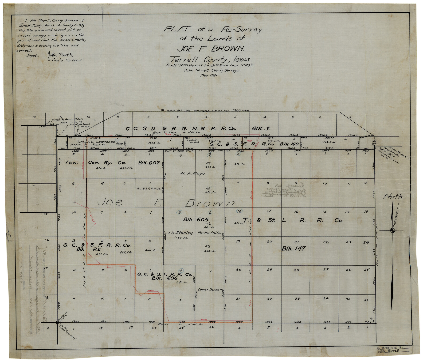
Terrell County Rolled Sketch 31
Plat of a re-survey of the lands of Joe F. Brown, Terrell County, Texas
-
Map/Doc
7937
-
Collection
General Map Collection
-
Object Dates
5/1931 (Creation Date)
-
People and Organizations
John Stovell (Surveyor/Engineer)
-
Counties
Terrell
-
Subjects
Surveying Rolled Sketch
-
Height x Width
24.4 x 28.4 inches
62.0 x 72.1 cm
-
Medium
linen, manuscript
-
Scale
1" = 1000 varas
Part of: General Map Collection
Palo Pinto County Sketch File 8

Print $40.00
- Digital $50.00
Palo Pinto County Sketch File 8
Size 15.3 x 15.6 inches
Map/Doc 33400
Cass County Working Sketch 21

Print $20.00
- Digital $50.00
Cass County Working Sketch 21
1961
Size 24.3 x 37.4 inches
Map/Doc 67924
Colorado County Sketch File 32

Print $4.00
- Digital $50.00
Colorado County Sketch File 32
1847
Size 13.0 x 8.4 inches
Map/Doc 18986
Harris County Rolled Sketch 88

Print $20.00
- Digital $50.00
Harris County Rolled Sketch 88
1935
Size 34.4 x 23.0 inches
Map/Doc 6121
Flight Mission No. BQR-9K, Frame 43, Brazoria County

Print $20.00
- Digital $50.00
Flight Mission No. BQR-9K, Frame 43, Brazoria County
1952
Size 18.6 x 22.3 inches
Map/Doc 84047
Roberts County Working Sketch 27

Print $20.00
- Digital $50.00
Roberts County Working Sketch 27
1982
Size 26.6 x 29.4 inches
Map/Doc 63553
Hardin County Sketch File 16a

Print $3.00
- Digital $50.00
Hardin County Sketch File 16a
1837
Size 10.4 x 16.0 inches
Map/Doc 25129
Hardeman County Working Sketch 16

Print $20.00
- Digital $50.00
Hardeman County Working Sketch 16
1982
Size 35.7 x 45.1 inches
Map/Doc 63397
Matagorda County Sketch File 39

Print $20.00
- Digital $50.00
Matagorda County Sketch File 39
Size 31.1 x 24.3 inches
Map/Doc 12047
Robertson County Sketch File 5

Print $6.00
Robertson County Sketch File 5
1863
Size 12.0 x 9.0 inches
Map/Doc 35358
Stonewall County Sketch File 26

Print $20.00
- Digital $50.00
Stonewall County Sketch File 26
1953
Size 35.7 x 36.8 inches
Map/Doc 10376
Uvalde County Working Sketch 50

Print $40.00
- Digital $50.00
Uvalde County Working Sketch 50
1980
Size 55.7 x 36.6 inches
Map/Doc 72120
You may also like
Red River County Working Sketch 25

Print $20.00
- Digital $50.00
Red River County Working Sketch 25
1959
Size 23.0 x 22.2 inches
Map/Doc 72008
Williamson County Rolled Sketch 5

Print $20.00
- Digital $50.00
Williamson County Rolled Sketch 5
1940
Size 23.7 x 34.5 inches
Map/Doc 8263
Karnes County Sketch File 12

Print $14.00
- Digital $50.00
Karnes County Sketch File 12
1889
Size 12.7 x 8.0 inches
Map/Doc 28604
Guadalupe County Sketch File 26

Print $4.00
- Digital $50.00
Guadalupe County Sketch File 26
1873
Size 10.2 x 8.2 inches
Map/Doc 24719
Map of Kimble County, Texas

Print $20.00
- Digital $50.00
Map of Kimble County, Texas
1879
Size 18.1 x 28.3 inches
Map/Doc 527
Borden County Sketch File 3a

Print $4.00
- Digital $50.00
Borden County Sketch File 3a
1902
Size 12.5 x 8.6 inches
Map/Doc 14705
Shelby County Working Sketch 15

Print $20.00
- Digital $50.00
Shelby County Working Sketch 15
1952
Size 24.5 x 19.2 inches
Map/Doc 63868
[T. & P. Surveys in Crane, Upton, Coke Counties]
![90464, [T. & P. Surveys in Crane, Upton, Coke Counties], Twichell Survey Records](https://historictexasmaps.com/wmedia_w700/maps/90464-1.tif.jpg)
Print $20.00
- Digital $50.00
[T. & P. Surveys in Crane, Upton, Coke Counties]
Size 19.2 x 21.2 inches
Map/Doc 90464
Flight Mission No. DQN-6K, Frame 13, Calhoun County

Print $20.00
- Digital $50.00
Flight Mission No. DQN-6K, Frame 13, Calhoun County
1953
Size 18.5 x 22.2 inches
Map/Doc 84435
Railroad Track Map, T&PRRCo., Culberson County, Texas

Print $4.00
- Digital $50.00
Railroad Track Map, T&PRRCo., Culberson County, Texas
1910
Size 11.7 x 18.6 inches
Map/Doc 62830
Hardin County Rolled Sketch 12

Print $20.00
- Digital $50.00
Hardin County Rolled Sketch 12
1949
Size 36.3 x 47.3 inches
Map/Doc 10200
Reeves County Working Sketch 9

Print $20.00
- Digital $50.00
Reeves County Working Sketch 9
1948
Size 19.0 x 24.0 inches
Map/Doc 63452