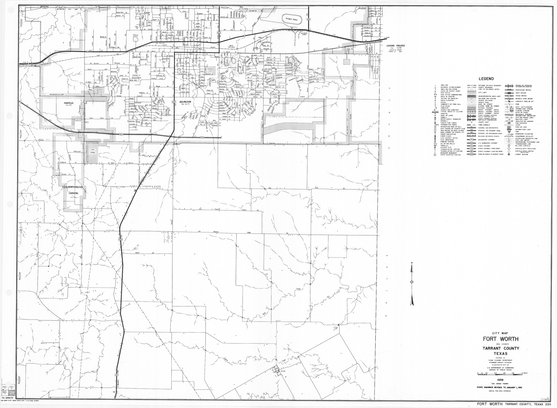
General Highway Map. Detail of Cities and Towns in Tarrant County, Texas. City Map, Fort Worth and vicinity, Tarrant County, Texas
-
Map/Doc
79671
-
Collection
Texas State Library and Archives
-
Object Dates
1961 (Creation Date)
-
People and Organizations
Texas State Highway Department (Publisher)
-
Counties
Tarrant
-
Subjects
City County
-
Height x Width
18.2 x 24.9 inches
46.2 x 63.3 cm
-
Comments
Prints available courtesy of the Texas State Library and Archives.
More info can be found here: TSLAC Map 05301
Part of: Texas State Library and Archives
General Highway Map, Galveston County, Texas

Print $20.00
General Highway Map, Galveston County, Texas
1961
Size 18.2 x 24.6 inches
Map/Doc 79476
General Highway Map, Leon County, Texas

Print $20.00
General Highway Map, Leon County, Texas
1940
Size 18.3 x 24.9 inches
Map/Doc 79172
General Highway Map, Calhoun County, Texas

Print $20.00
General Highway Map, Calhoun County, Texas
1961
Size 18.3 x 24.4 inches
Map/Doc 79395
General Highway Map, Glasscock County, Texas

Print $20.00
General Highway Map, Glasscock County, Texas
1961
Size 18.2 x 24.8 inches
Map/Doc 79480
General Highway Map, Kaufman County, Texas

Print $20.00
General Highway Map, Kaufman County, Texas
1939
Size 24.8 x 18.3 inches
Map/Doc 79152
General Highway Map, Crockett County, Texas

Print $20.00
General Highway Map, Crockett County, Texas
1940
Size 18.3 x 25.1 inches
Map/Doc 79062
Map of the United States to accompany Granger's Southern and Western Texas Guide

Print $20.00
Map of the United States to accompany Granger's Southern and Western Texas Guide
1878
Size 26.4 x 20.4 inches
Map/Doc 76236
General Highway Map. Detail of Cities and Towns in McLennan County, Texas

Print $20.00
General Highway Map. Detail of Cities and Towns in McLennan County, Texas
1961
Size 18.2 x 24.6 inches
Map/Doc 79591
General Highway Map, Stonewall County, Texas

Print $20.00
General Highway Map, Stonewall County, Texas
1961
Size 18.3 x 25.1 inches
Map/Doc 79662
General Highway Map, El Paso County, Texas

Print $20.00
General Highway Map, El Paso County, Texas
1940
Size 18.4 x 24.7 inches
Map/Doc 79084
General Highway Map, Live Oak County, Texas

Print $20.00
General Highway Map, Live Oak County, Texas
1940
Size 18.4 x 24.8 inches
Map/Doc 79177
General Highway Map, Motley County, Texas

Print $20.00
General Highway Map, Motley County, Texas
1940
Size 24.5 x 18.2 inches
Map/Doc 79204
You may also like
Stonewall County Sketch File 28

Print $14.00
- Digital $50.00
Stonewall County Sketch File 28
1970
Size 14.3 x 8.9 inches
Map/Doc 37300
Young County Working Sketch 15

Print $20.00
- Digital $50.00
Young County Working Sketch 15
1952
Size 13.7 x 18.0 inches
Map/Doc 62038
Middle Sulphur and South Sulphur Rivers, Horton Sheet

Print $20.00
- Digital $50.00
Middle Sulphur and South Sulphur Rivers, Horton Sheet
1925
Size 25.6 x 22.0 inches
Map/Doc 78330
Flight Mission No. BQR-7K, Frame 28, Brazoria County

Print $20.00
- Digital $50.00
Flight Mission No. BQR-7K, Frame 28, Brazoria County
1952
Size 18.5 x 22.2 inches
Map/Doc 84026
Upton County Rolled Sketch 19

Print $40.00
- Digital $50.00
Upton County Rolled Sketch 19
1933
Size 55.2 x 40.0 inches
Map/Doc 10040
Castro County Sketch File 9

Print $4.00
- Digital $50.00
Castro County Sketch File 9
1908
Size 11.2 x 8.6 inches
Map/Doc 17499
Runnels County Working Sketch 17

Print $20.00
- Digital $50.00
Runnels County Working Sketch 17
1950
Size 27.1 x 21.5 inches
Map/Doc 63613
San Saba County Sketch File 12

Print $6.00
- Digital $50.00
San Saba County Sketch File 12
Size 11.8 x 9.3 inches
Map/Doc 36439
Map of Young County

Print $20.00
- Digital $50.00
Map of Young County
Size 25.1 x 29.3 inches
Map/Doc 92803
Kaufman County, 1887

Print $20.00
- Digital $50.00
Kaufman County, 1887
1887
Size 42.6 x 46.1 inches
Map/Doc 89701
Falls County Boundary File 1

Print $64.00
- Digital $50.00
Falls County Boundary File 1
Size 9.2 x 4.4 inches
Map/Doc 53241
Current Miscellaneous File 34

Print $10.00
- Digital $50.00
Current Miscellaneous File 34
1953
Size 14.1 x 8.7 inches
Map/Doc 73942