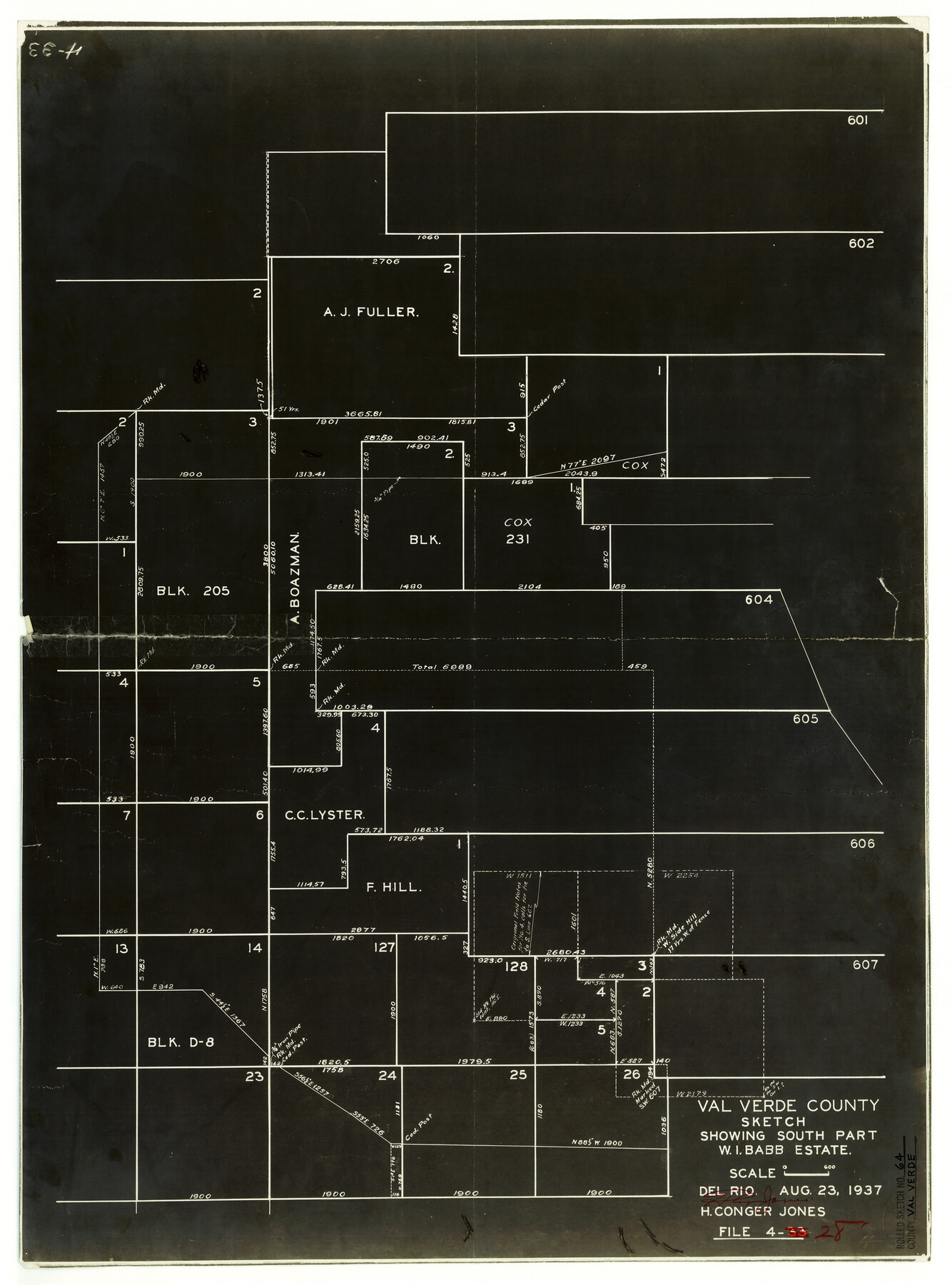
Val Verde County Rolled Sketch 64
Val Verde County sketch showing south part W.I. Babb estate
-
Map/Doc
8129
-
Collection
General Map Collection
-
Object Dates
1937/8/23 (Creation Date)
1956/12/7 (File Date)
-
People and Organizations
H. Conger Jones (Surveyor/Engineer)
-
Counties
Val Verde
-
Subjects
Surveying Rolled Sketch
-
Height x Width
24.6 x 18.2 inches
62.5 x 46.2 cm
-
Medium
photostat
Part of: General Map Collection
Flight Mission No. DIX-8P, Frame 61, Aransas County

Print $20.00
- Digital $50.00
Flight Mission No. DIX-8P, Frame 61, Aransas County
1956
Size 18.8 x 22.6 inches
Map/Doc 83892
Presidio County Rolled Sketch 96

Print $20.00
- Digital $50.00
Presidio County Rolled Sketch 96
Size 12.3 x 45.9 inches
Map/Doc 9782
Concho County Sketch File 47

Print $20.00
- Digital $50.00
Concho County Sketch File 47
1950
Size 16.8 x 21.0 inches
Map/Doc 11165
Flight Mission No. CRC-3R, Frame 20, Chambers County

Print $20.00
- Digital $50.00
Flight Mission No. CRC-3R, Frame 20, Chambers County
1956
Size 18.6 x 22.2 inches
Map/Doc 84794
Denton County Working Sketch 1

Print $20.00
- Digital $50.00
Denton County Working Sketch 1
1920
Size 16.1 x 12.9 inches
Map/Doc 68606
Flight Mission No. DQN-2K, Frame 164, Calhoun County

Print $20.00
- Digital $50.00
Flight Mission No. DQN-2K, Frame 164, Calhoun County
1953
Size 18.7 x 22.5 inches
Map/Doc 84326
[Location, Chicago & Rock Island Railroad Through Tarrant County]
![64343, [Location, Chicago & Rock Island Railroad Through Tarrant County], General Map Collection](https://historictexasmaps.com/wmedia_w700/maps/64343.tif.jpg)
Print $40.00
- Digital $50.00
[Location, Chicago & Rock Island Railroad Through Tarrant County]
Size 25.9 x 115.5 inches
Map/Doc 64343
Presidio County Rolled Sketch 39

Print $20.00
- Digital $50.00
Presidio County Rolled Sketch 39
Size 16.0 x 22.0 inches
Map/Doc 7336
Cass County Sketch File 18

Print $4.00
- Digital $50.00
Cass County Sketch File 18
Size 7.4 x 10.3 inches
Map/Doc 17420
Nueces County Rolled Sketch 6

Print $20.00
- Digital $50.00
Nueces County Rolled Sketch 6
Size 37.8 x 22.2 inches
Map/Doc 6867
Gray County Working Sketch Graphic Index

Print $20.00
- Digital $50.00
Gray County Working Sketch Graphic Index
1900
Size 43.3 x 39.4 inches
Map/Doc 76557
Duval County Working Sketch 47

Print $20.00
- Digital $50.00
Duval County Working Sketch 47
1981
Size 20.8 x 30.9 inches
Map/Doc 68771
You may also like
Cameron County Rolled Sketch 24

Print $40.00
- Digital $50.00
Cameron County Rolled Sketch 24
1968
Size 30.4 x 66.7 inches
Map/Doc 8574
United States, 1956 Revised Edition

Print $20.00
- Digital $50.00
United States, 1956 Revised Edition
1946
Size 47.9 x 35.9 inches
Map/Doc 78630
Map showing conflict of Rusk Transportation Co. with Lazarus and I. R.R. Co. Surveys

Print $20.00
- Digital $50.00
Map showing conflict of Rusk Transportation Co. with Lazarus and I. R.R. Co. Surveys
1914
Size 28.9 x 16.6 inches
Map/Doc 75825
Hays County Sketch File 35

Print $4.00
- Digital $50.00
Hays County Sketch File 35
1873
Size 12.8 x 8.2 inches
Map/Doc 26277
Bosque County Sketch File 6

Print $4.00
- Digital $50.00
Bosque County Sketch File 6
1851
Size 12.1 x 7.6 inches
Map/Doc 14748
Crane County Sketch File 28

Print $6.00
- Digital $50.00
Crane County Sketch File 28
1953
Size 11.5 x 9.1 inches
Map/Doc 19605
Bowie County Sketch File 10

Print $8.00
- Digital $50.00
Bowie County Sketch File 10
1992
Size 11.1 x 8.8 inches
Map/Doc 14912
Ward County Rolled Sketch 12

Print $20.00
- Digital $50.00
Ward County Rolled Sketch 12
Size 38.2 x 47.8 inches
Map/Doc 10107
Rio Grande Rectification Project, El Paso and Juarez Valley

Print $20.00
- Digital $50.00
Rio Grande Rectification Project, El Paso and Juarez Valley
1935
Size 10.7 x 29.5 inches
Map/Doc 60869
Gaines County Rolled Sketch G3

Print $20.00
- Digital $50.00
Gaines County Rolled Sketch G3
1902
Size 22.7 x 31.4 inches
Map/Doc 5946
Map of subdivision of submerged land in the Gulf of Mexico fronting on Matagorda Island and Peninsula

Print $40.00
- Digital $50.00
Map of subdivision of submerged land in the Gulf of Mexico fronting on Matagorda Island and Peninsula
1940
Size 22.8 x 76.5 inches
Map/Doc 2932
