Travis County State Real Property Sketch 11
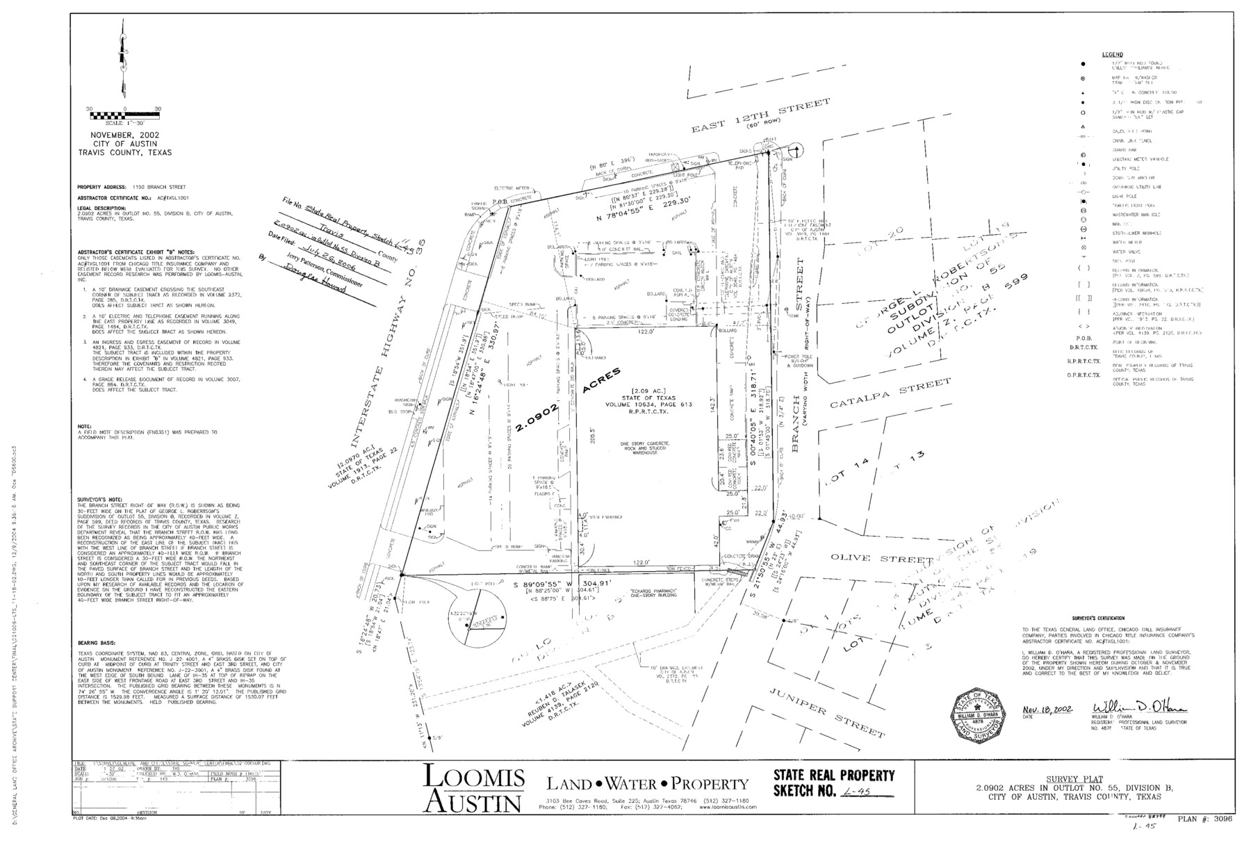
A Survey Plat of 2.0902 Acres in Outlot No. 55, Division B, City of Austin
State Real Property Sketch L-45
-
Map/Doc
85799
-
Collection
General Map Collection
-
Object Dates
11/7/2002 (Creation Date)
7/26/2006 (File Date)
-
People and Organizations
Bill O'Hara (Surveyor/Engineer)
-
Counties
Travis
-
Subjects
State Real Property
-
Height x Width
24.3 x 36.0 inches
61.7 x 91.4 cm
-
Scale
1" = 30 feet
-
Comments
Surveys located about one mile South 80 degrees East of Austin, Texas.
Part of: General Map Collection
Flight Mission No. CRK-3P, Frame 66, Refugio County

Print $20.00
- Digital $50.00
Flight Mission No. CRK-3P, Frame 66, Refugio County
1956
Size 18.6 x 22.4 inches
Map/Doc 86908
Montague County Rolled Sketch 4

Print $20.00
- Digital $50.00
Montague County Rolled Sketch 4
1940
Size 37.8 x 20.5 inches
Map/Doc 6788
Pecos County Rolled Sketch 136

Print $20.00
- Digital $50.00
Pecos County Rolled Sketch 136
1952
Size 24.7 x 17.6 inches
Map/Doc 7272
Nueces County Rolled Sketch 44

Print $40.00
- Digital $50.00
Nueces County Rolled Sketch 44
1948
Size 40.0 x 60.8 inches
Map/Doc 9602
Van Zandt County Sketch File 29c

Print $4.00
- Digital $50.00
Van Zandt County Sketch File 29c
1861
Size 8.2 x 8.3 inches
Map/Doc 39459
Upshur County Sketch File 9

Print $4.00
- Digital $50.00
Upshur County Sketch File 9
1847
Size 8.4 x 10.3 inches
Map/Doc 38748
Uvalde County Working Sketch 58

Print $20.00
- Digital $50.00
Uvalde County Working Sketch 58
1968
Size 29.3 x 23.3 inches
Map/Doc 72128
Dimmit County Working Sketch 16

Print $20.00
- Digital $50.00
Dimmit County Working Sketch 16
1943
Size 25.6 x 24.8 inches
Map/Doc 68677
Jones County Sketch File 15

Print $40.00
- Digital $50.00
Jones County Sketch File 15
1892
Size 13.7 x 16.3 inches
Map/Doc 28503
Freestone County Working Sketch 11

Print $40.00
- Digital $50.00
Freestone County Working Sketch 11
1978
Size 31.4 x 51.4 inches
Map/Doc 69253
Duval County Sketch File 27

Print $6.00
- Digital $50.00
Duval County Sketch File 27
1919
Size 11.0 x 11.8 inches
Map/Doc 21334
Bell County Sketch File 21

Print $4.00
- Digital $50.00
Bell County Sketch File 21
1871
Size 8.0 x 9.7 inches
Map/Doc 14410
You may also like
Leon County Rolled Sketch 30

Print $20.00
- Digital $50.00
Leon County Rolled Sketch 30
Size 30.9 x 25.7 inches
Map/Doc 6613
Culberson County Working Sketch 58

Print $20.00
- Digital $50.00
Culberson County Working Sketch 58
1974
Size 45.2 x 35.1 inches
Map/Doc 68512
Foard County Sketch File 26

Print $40.00
- Digital $50.00
Foard County Sketch File 26
Size 13.5 x 17.7 inches
Map/Doc 22856

Schönberg's map of Texas.

Print $20.00
Schönberg's map of Texas.
1866
Size 11.0 x 13.0 inches
Map/Doc 93575
Culberson County Working Sketch 67

Print $40.00
- Digital $50.00
Culberson County Working Sketch 67
1975
Size 48.9 x 33.2 inches
Map/Doc 68521
Jim Hogg County

Print $20.00
- Digital $50.00
Jim Hogg County
1962
Size 41.3 x 30.0 inches
Map/Doc 73197

Mapa topográfico de la provincia de Texas

Print $20.00
Mapa topográfico de la provincia de Texas
1822
Size 10.2 x 13.9 inches
Map/Doc 89228
Seminole Cemetery, Gaines County, Texas

Print $20.00
- Digital $50.00
Seminole Cemetery, Gaines County, Texas
Size 29.2 x 31.7 inches
Map/Doc 92690
The Republic County of Austin. January 29, 1842

Print $20.00
The Republic County of Austin. January 29, 1842
2020
Size 14.7 x 21.7 inches
Map/Doc 96086
Flight Mission No. BRA-3M, Frame 199, Jefferson County

Print $20.00
- Digital $50.00
Flight Mission No. BRA-3M, Frame 199, Jefferson County
1953
Size 18.6 x 22.3 inches
Map/Doc 85414