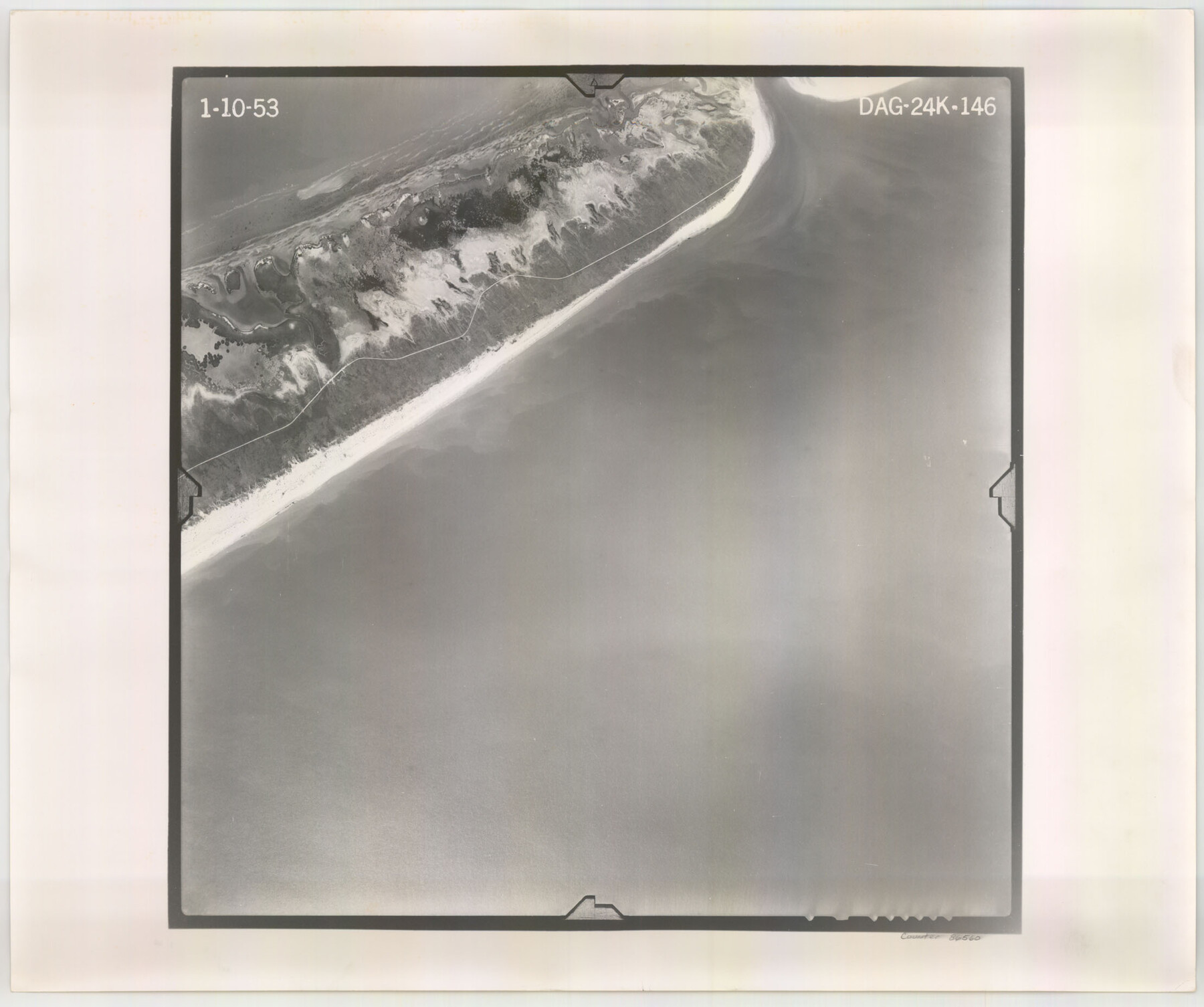
Flight Mission No. DAG-24K, Frame 146, Matagorda County
DAG-24K-146
-
Map/Doc
86560
-
Collection
General Map Collection
-
Object Dates
1953/1/10 (Creation Date)
-
People and Organizations
U. S. Department of Agriculture (Publisher)
-
Counties
Matagorda
-
Subjects
Aerial Photograph
-
Height x Width
18.6 x 22.2 inches
47.2 x 56.4 cm
-
Comments
Flown by Aero Exploration Company of Tulsa, Oklahoma.
Part of: General Map Collection
Harris County Sketch File 56

Print $4.00
- Digital $50.00
Harris County Sketch File 56
1918
Size 8.2 x 12.8 inches
Map/Doc 25454
Galveston County Rolled Sketch V

Print $20.00
- Digital $50.00
Galveston County Rolled Sketch V
1934
Size 38.7 x 30.3 inches
Map/Doc 5992
Bastrop County Working Sketch 16

Print $20.00
- Digital $50.00
Bastrop County Working Sketch 16
1998
Size 39.2 x 34.1 inches
Map/Doc 67316
Cameron County Rolled Sketch 8

Print $40.00
- Digital $50.00
Cameron County Rolled Sketch 8
1937
Size 42.5 x 54.1 inches
Map/Doc 8565
Harrison County Sketch File 15

Print $20.00
- Digital $50.00
Harrison County Sketch File 15
Size 23.2 x 23.0 inches
Map/Doc 11690
[Location Survey of the Southern Kansas Railway, Kiowa Extension from a point in Drake's Location, in Indian Territory 100 miles from south line of Kansas, continuing up Wolf Creek and South Canadian River to Cottonwood Creek in Hutchinson County]
![88844, [Location Survey of the Southern Kansas Railway, Kiowa Extension from a point in Drake's Location, in Indian Territory 100 miles from south line of Kansas, continuing up Wolf Creek and South Canadian River to Cottonwood Creek in Hutchinson County], General Map Collection](https://historictexasmaps.com/wmedia_w700/maps/88844.tif.jpg)
Print $20.00
- Digital $50.00
[Location Survey of the Southern Kansas Railway, Kiowa Extension from a point in Drake's Location, in Indian Territory 100 miles from south line of Kansas, continuing up Wolf Creek and South Canadian River to Cottonwood Creek in Hutchinson County]
1886
Size 39.0 x 40.0 inches
Map/Doc 88844
Trinity River, Reagor Springs Sheet/Waxahachie Creek

Print $4.00
- Digital $50.00
Trinity River, Reagor Springs Sheet/Waxahachie Creek
1931
Size 29.9 x 25.6 inches
Map/Doc 65236
Rusk County Working Sketch 37b

Print $40.00
- Digital $50.00
Rusk County Working Sketch 37b
2007
Size 50.0 x 31.0 inches
Map/Doc 87497
Acreage in Texas by Counties

Acreage in Texas by Counties
1983
Size 10.3 x 11.8 inches
Map/Doc 97033
Hidalgo County Rolled Sketch 9

Print $20.00
- Digital $50.00
Hidalgo County Rolled Sketch 9
1906
Size 18.9 x 24.8 inches
Map/Doc 6210
[Map of the Fort Worth & Denver City Railway, Hartley County, Texas]
![64389, [Map of the Fort Worth & Denver City Railway, Hartley County, Texas], General Map Collection](https://historictexasmaps.com/wmedia_w700/maps/64389.tif.jpg)
Print $40.00
- Digital $50.00
[Map of the Fort Worth & Denver City Railway, Hartley County, Texas]
1887
Size 22.0 x 120.7 inches
Map/Doc 64389
Flight Mission No. BRE-2P, Frame 102, Nueces County

Print $20.00
- Digital $50.00
Flight Mission No. BRE-2P, Frame 102, Nueces County
1956
Size 18.4 x 22.2 inches
Map/Doc 86787
You may also like
Martin County Working Sketch 12

Print $40.00
- Digital $50.00
Martin County Working Sketch 12
1971
Size 48.2 x 35.6 inches
Map/Doc 70830
General Highway Map. Detail of Cities and Towns in Galveston County, Texas. City Map of Galveston and vicinity, Galveston County, Texas

Print $20.00
General Highway Map. Detail of Cities and Towns in Galveston County, Texas. City Map of Galveston and vicinity, Galveston County, Texas
1961
Size 18.1 x 24.6 inches
Map/Doc 79477
Culberson County Rolled Sketch 10

Print $20.00
- Digital $50.00
Culberson County Rolled Sketch 10
1893
Size 16.4 x 25.9 inches
Map/Doc 5647
C.C. Slaughter's Running Water Ranch situated in Hale and Lamb Counties

Print $40.00
- Digital $50.00
C.C. Slaughter's Running Water Ranch situated in Hale and Lamb Counties
Size 38.1 x 55.5 inches
Map/Doc 89924
Dallam County Working Sketch 5

Print $20.00
- Digital $50.00
Dallam County Working Sketch 5
1990
Size 39.0 x 33.1 inches
Map/Doc 68590
Pecos County Rolled Sketch 69A

Print $20.00
- Digital $50.00
Pecos County Rolled Sketch 69A
1928
Size 44.3 x 35.9 inches
Map/Doc 9702
Hudspeth County Working Sketch 1

Print $40.00
- Digital $50.00
Hudspeth County Working Sketch 1
1911
Size 26.5 x 53.3 inches
Map/Doc 69023
Sutton County Boundary File 5

Print $28.00
- Digital $50.00
Sutton County Boundary File 5
Size 14.2 x 8.7 inches
Map/Doc 59046
Foard County Sketch File 19

Print $20.00
- Digital $50.00
Foard County Sketch File 19
1899
Size 17.7 x 16.5 inches
Map/Doc 11493
Jeff Davis County Sketch File 3

Print $22.00
- Digital $50.00
Jeff Davis County Sketch File 3
Size 12.3 x 8.6 inches
Map/Doc 27892
Sabine County Working Sketch 13

Print $20.00
- Digital $50.00
Sabine County Working Sketch 13
1935
Size 35.3 x 44.2 inches
Map/Doc 63684
[H. & T. C. 46, Sections 79- 84]
![91262, [H. & T. C. 46, Sections 79- 84], Twichell Survey Records](https://historictexasmaps.com/wmedia_w700/maps/91262-1.tif.jpg)
Print $20.00
- Digital $50.00
[H. & T. C. 46, Sections 79- 84]
Size 27.3 x 32.6 inches
Map/Doc 91262