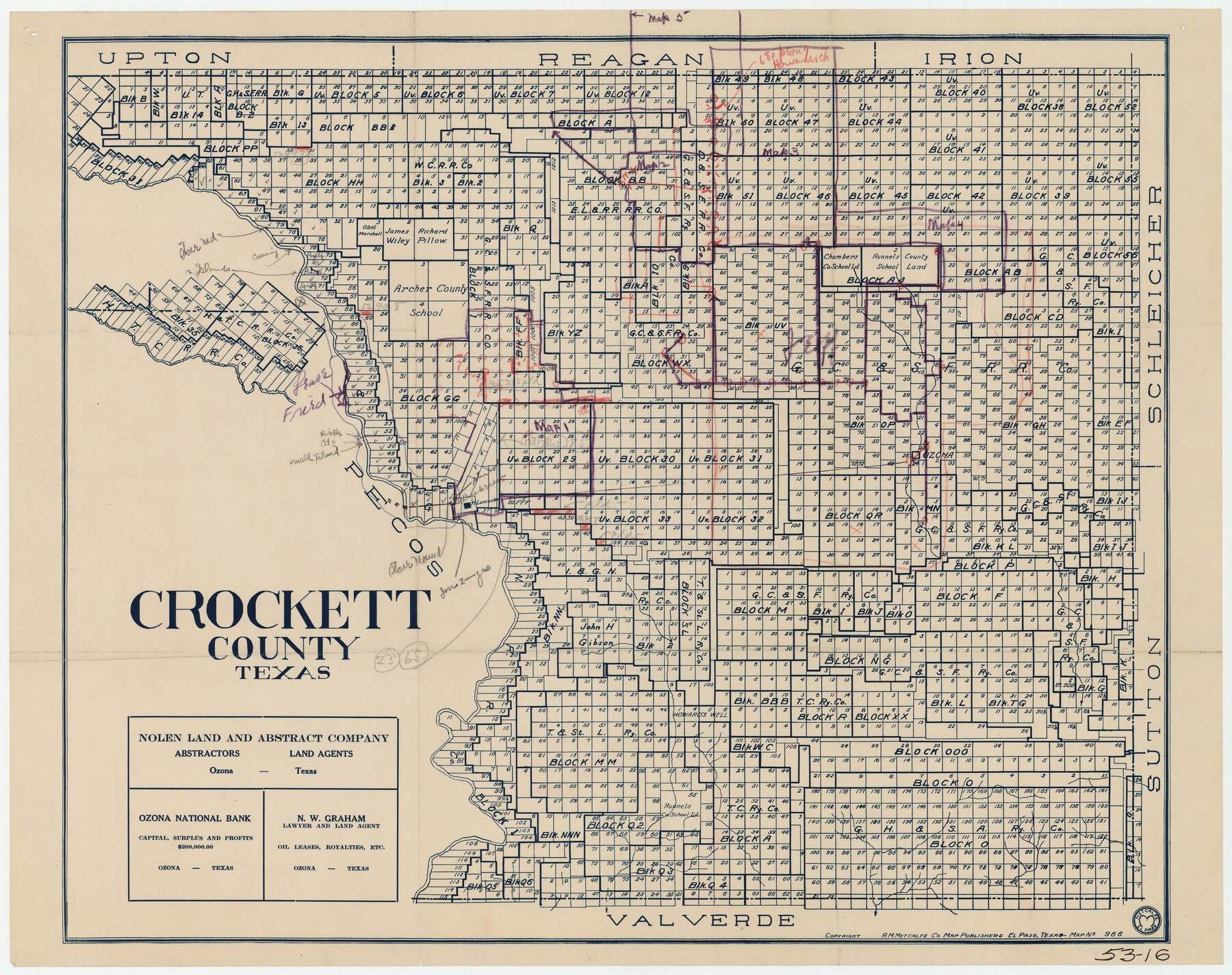
Crockett County, Texas
53-16
-
Map/Doc
90316
-
Collection
Twichell Survey Records
-
People and Organizations
R. M. Metcalfe Co. Map Publishers (Publisher)
-
Counties
Crockett
-
Subjects
County
-
Height x Width
24.7 x 19.5 inches
62.7 x 49.5 cm
Part of: Twichell Survey Records
Map Showing Eastern Portion of Pecos County, Texas

Print $40.00
- Digital $50.00
Map Showing Eastern Portion of Pecos County, Texas
Size 62.2 x 43.5 inches
Map/Doc 89835
Udell -V- Hughes Sketch

Print $20.00
- Digital $50.00
Udell -V- Hughes Sketch
Size 28.8 x 19.4 inches
Map/Doc 90481
[Sketch highlighting Bob Reid and Fred Turner surveys]
![91694, [Sketch highlighting Bob Reid and Fred Turner surveys], Twichell Survey Records](https://historictexasmaps.com/wmedia_w700/maps/91694-1.tif.jpg)
Print $20.00
- Digital $50.00
[Sketch highlighting Bob Reid and Fred Turner surveys]
Size 12.5 x 17.6 inches
Map/Doc 91694
Bravo Deed, Instrument 24, Tract A and Tract B

Print $3.00
- Digital $50.00
Bravo Deed, Instrument 24, Tract A and Tract B
Size 11.4 x 14.2 inches
Map/Doc 91479
John B. Slaughter Ranch Situated in Garza County, Texas

Print $20.00
- Digital $50.00
John B. Slaughter Ranch Situated in Garza County, Texas
Size 32.5 x 44.7 inches
Map/Doc 92657
James Subdivision, NE/4 Section 1, Block E, G. C. & S. F. R.R. Co. Cert 3/360, Abstract 46

Print $3.00
- Digital $50.00
James Subdivision, NE/4 Section 1, Block E, G. C. & S. F. R.R. Co. Cert 3/360, Abstract 46
Size 11.0 x 12.2 inches
Map/Doc 92705
Plat showing proposed Water Permit on Cow Bayou in Orange County, Texas

Print $20.00
- Digital $50.00
Plat showing proposed Water Permit on Cow Bayou in Orange County, Texas
1922
Size 24.3 x 16.4 inches
Map/Doc 93017
[Littlefield Subdivision Blocks 657-687]
![91008, [Littlefield Subdivision Blocks 657-687], Twichell Survey Records](https://historictexasmaps.com/wmedia_w700/maps/91008-1.tif.jpg)
Print $20.00
- Digital $50.00
[Littlefield Subdivision Blocks 657-687]
Size 15.7 x 12.1 inches
Map/Doc 91008
General Highway Map, Hale County, Texas

Print $20.00
- Digital $50.00
General Highway Map, Hale County, Texas
1949
Size 18.8 x 25.9 inches
Map/Doc 92661
Dawson County Sketch showing survey made in accordance with an order of the Hon. District Court of Garza County July Term A.D. 1917 in the case of F. M. Weaver vs. A. W. Higginbotham #41

Print $20.00
- Digital $50.00
Dawson County Sketch showing survey made in accordance with an order of the Hon. District Court of Garza County July Term A.D. 1917 in the case of F. M. Weaver vs. A. W. Higginbotham #41
1917
Size 23.1 x 18.1 inches
Map/Doc 90637
Borden County

Print $20.00
- Digital $50.00
Borden County
1922
Size 36.8 x 41.7 inches
Map/Doc 92457
Sketch showing recent surveys of State School Land adjoining Capitol Leagues No. 357 1/2, 367, 373 and 374 corrected out of conflict

Print $2.00
- Digital $50.00
Sketch showing recent surveys of State School Land adjoining Capitol Leagues No. 357 1/2, 367, 373 and 374 corrected out of conflict
1905
Size 7.4 x 10.5 inches
Map/Doc 90533
You may also like
Crosby County Sketch File 20

Print $20.00
- Digital $50.00
Crosby County Sketch File 20
Size 25.9 x 18.3 inches
Map/Doc 11252
[Gulf, Colorado & Santa Fe Railway Company]
![64411, [Gulf, Colorado & Santa Fe Railway Company], General Map Collection](https://historictexasmaps.com/wmedia_w700/maps/64411.tif.jpg)
Print $20.00
- Digital $50.00
[Gulf, Colorado & Santa Fe Railway Company]
1893
Size 20.1 x 41.5 inches
Map/Doc 64411
Ward County Working Sketch Graphic Index - sheet A

Print $40.00
- Digital $50.00
Ward County Working Sketch Graphic Index - sheet A
1932
Size 30.8 x 52.8 inches
Map/Doc 76731
Map of Nacogdoches County

Print $20.00
- Digital $50.00
Map of Nacogdoches County
1857
Size 22.9 x 24.3 inches
Map/Doc 3907
Flight Mission No. BRA-8M, Frame 142, Jefferson County

Print $20.00
- Digital $50.00
Flight Mission No. BRA-8M, Frame 142, Jefferson County
1953
Size 18.5 x 22.1 inches
Map/Doc 85634
Denton County Boundary File 4 and 4a and 4b and 4c

Print $14.00
- Digital $50.00
Denton County Boundary File 4 and 4a and 4b and 4c
Size 11.2 x 8.5 inches
Map/Doc 52441
[Randall County map]
![91752, [Randall County map], Twichell Survey Records](https://historictexasmaps.com/wmedia_w700/maps/91752-1.tif.jpg)
Print $20.00
- Digital $50.00
[Randall County map]
Size 21.3 x 17.0 inches
Map/Doc 91752
Maps of Gulf Intracoastal Waterway, Texas - Sabine River to the Rio Grande and connecting waterways including ship channels

Print $20.00
- Digital $50.00
Maps of Gulf Intracoastal Waterway, Texas - Sabine River to the Rio Grande and connecting waterways including ship channels
1966
Size 14.5 x 22.2 inches
Map/Doc 61941
Milam County Working Sketch 16

Print $20.00
- Digital $50.00
Milam County Working Sketch 16
Size 30.4 x 36.2 inches
Map/Doc 71028
Flight Mission No. CRE-1R, Frame 193, Jackson County

Print $20.00
- Digital $50.00
Flight Mission No. CRE-1R, Frame 193, Jackson County
1956
Size 18.5 x 22.2 inches
Map/Doc 85347
Reeves County Sketch File 4

Print $20.00
- Digital $50.00
Reeves County Sketch File 4
Size 32.8 x 12.2 inches
Map/Doc 12240
General Highway Map, Borden County, Texas

Print $20.00
General Highway Map, Borden County, Texas
1940
Size 18.5 x 25.0 inches
Map/Doc 79021