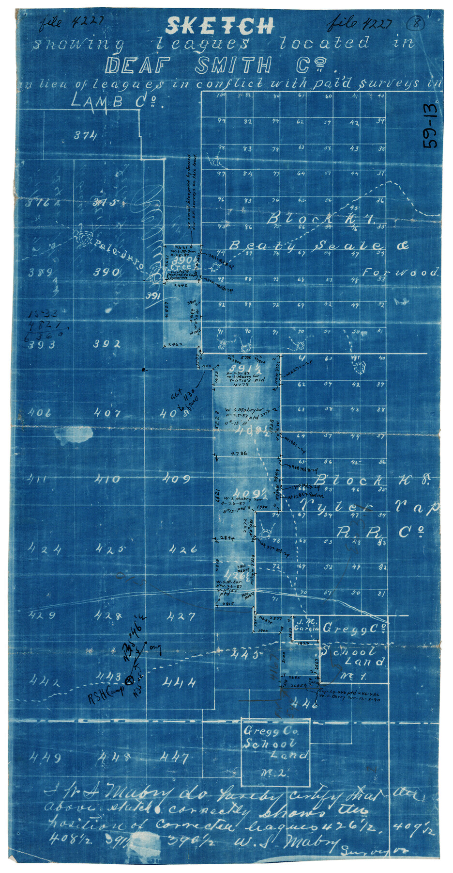
Sketch Showing Leagues Located in Deaf Smith Co. in lieu of Leagues in conflict with paid surveys
59-13
-
Map/Doc
90529
-
Collection
Twichell Survey Records
-
Counties
Deaf Smith
-
Height x Width
8.2 x 15.7 inches
20.8 x 39.9 cm
Part of: Twichell Survey Records
[H. & T. C. Block 47 and vicinity]
![91171, [H. & T. C. Block 47 and vicinity], Twichell Survey Records](https://historictexasmaps.com/wmedia_w700/maps/91171-1.tif.jpg)
Print $20.00
- Digital $50.00
[H. & T. C. Block 47 and vicinity]
1891
Size 19.4 x 15.3 inches
Map/Doc 91171
[H. & T. C. RR. Company Block 47, Sections 47, 48, 49, 50, 51, and 52]
![91221, [H. & T. C. RR. Company Block 47, Sections 47, 48, 49, 50, 51, and 52], Twichell Survey Records](https://historictexasmaps.com/wmedia_w700/maps/91221-1.tif.jpg)
Print $2.00
- Digital $50.00
[H. & T. C. RR. Company Block 47, Sections 47, 48, 49, 50, 51, and 52]
Size 8.5 x 11.2 inches
Map/Doc 91221
Map of Rotan Fisher County, Texas

Print $20.00
- Digital $50.00
Map of Rotan Fisher County, Texas
1926
Size 32.2 x 36.5 inches
Map/Doc 93231
[Northeast 1/4 of County]
![91629, [Northeast 1/4 of County], Twichell Survey Records](https://historictexasmaps.com/wmedia_w700/maps/91629-1.tif.jpg)
Print $2.00
- Digital $50.00
[Northeast 1/4 of County]
Size 12.3 x 9.0 inches
Map/Doc 91629
[Sketch of Surveys south of League 153]
![90437, [Sketch of Surveys south of League 153], Twichell Survey Records](https://historictexasmaps.com/wmedia_w700/maps/90437-1.tif.jpg)
Print $2.00
- Digital $50.00
[Sketch of Surveys south of League 153]
Size 9.5 x 5.9 inches
Map/Doc 90437
Cliffside Situated on Section 21, Block 9, Potter County, Texas

Print $2.00
- Digital $50.00
Cliffside Situated on Section 21, Block 9, Potter County, Texas
Size 6.1 x 11.5 inches
Map/Doc 92100
[Blocks C4, SI, and JK]
![90774, [Blocks C4, SI, and JK], Twichell Survey Records](https://historictexasmaps.com/wmedia_w700/maps/90774-1.tif.jpg)
Print $20.00
- Digital $50.00
[Blocks C4, SI, and JK]
Size 16.1 x 16.3 inches
Map/Doc 90774
Culberson County

Print $40.00
- Digital $50.00
Culberson County
1924
Size 32.4 x 48.5 inches
Map/Doc 92559
Cienega Ranch

Print $20.00
- Digital $50.00
Cienega Ranch
1947
Size 27.6 x 28.3 inches
Map/Doc 92323
Sketch of Resurvey, Township 5 North. Block 36. Texas and Pacific Railroad Company, Dawson County

Print $20.00
- Digital $50.00
Sketch of Resurvey, Township 5 North. Block 36. Texas and Pacific Railroad Company, Dawson County
1926
Size 24.6 x 25.0 inches
Map/Doc 92572
East Half Section 3, Block 2, D. & S. E. RR. Company; West Half Section 3, E. L. & R. R. RR. Company

Print $20.00
- Digital $50.00
East Half Section 3, Block 2, D. & S. E. RR. Company; West Half Section 3, E. L. & R. R. RR. Company
Size 22.0 x 22.7 inches
Map/Doc 92595
[Blocks D3 and GP]
![91506, [Blocks D3 and GP], Twichell Survey Records](https://historictexasmaps.com/wmedia_w700/maps/91506-1.tif.jpg)
Print $20.00
- Digital $50.00
[Blocks D3 and GP]
Size 18.2 x 19.3 inches
Map/Doc 91506
You may also like
Real County Working Sketch 27

Print $20.00
- Digital $50.00
Real County Working Sketch 27
1947
Size 29.8 x 29.2 inches
Map/Doc 71919
Shackelford County

Print $20.00
- Digital $50.00
Shackelford County
1920
Size 39.2 x 46.1 inches
Map/Doc 93031
[Sketch showing surveys located in Block 6]
![91751, [Sketch showing surveys located in Block 6], Twichell Survey Records](https://historictexasmaps.com/wmedia_w700/maps/91751-1.tif.jpg)
Print $20.00
- Digital $50.00
[Sketch showing surveys located in Block 6]
Size 19.7 x 15.8 inches
Map/Doc 91751
Part of Garza, Crosby, Lynn, and Lubbock Counties

Print $20.00
- Digital $50.00
Part of Garza, Crosby, Lynn, and Lubbock Counties
1912
Size 25.4 x 20.4 inches
Map/Doc 91328
Copy of Surveyor's Field Book, Morris Browning - In Blocks 7, 5 & 4, I&GNRRCo., Hutchinson and Carson Counties, Texas

Print $2.00
- Digital $50.00
Copy of Surveyor's Field Book, Morris Browning - In Blocks 7, 5 & 4, I&GNRRCo., Hutchinson and Carson Counties, Texas
1888
Size 6.9 x 8.8 inches
Map/Doc 62260
Chambers County Rolled Sketch 21

Print $20.00
- Digital $50.00
Chambers County Rolled Sketch 21
1940
Size 42.2 x 44.9 inches
Map/Doc 8590
Matagorda County Rolled Sketch 18A

Print $20.00
- Digital $50.00
Matagorda County Rolled Sketch 18A
1838
Size 35.4 x 30.1 inches
Map/Doc 6686
Crosby County Sketch File 30

Print $4.00
- Digital $50.00
Crosby County Sketch File 30
1935
Size 11.4 x 7.4 inches
Map/Doc 20102
Zavala County Working Sketch 29

Print $20.00
- Digital $50.00
Zavala County Working Sketch 29
1994
Size 33.1 x 42.9 inches
Map/Doc 62104
Reeves County Working Sketch 54

Print $20.00
- Digital $50.00
Reeves County Working Sketch 54
1978
Size 36.9 x 35.6 inches
Map/Doc 63497
[Leagues in Northwest Lamb County]
![91073, [Leagues in Northwest Lamb County], Twichell Survey Records](https://historictexasmaps.com/wmedia_w700/maps/91073-1.tif.jpg)
Print $20.00
- Digital $50.00
[Leagues in Northwest Lamb County]
Size 19.5 x 23.2 inches
Map/Doc 91073
Jack County Working Sketch 7

Print $20.00
- Digital $50.00
Jack County Working Sketch 7
1953
Size 37.2 x 31.9 inches
Map/Doc 66433