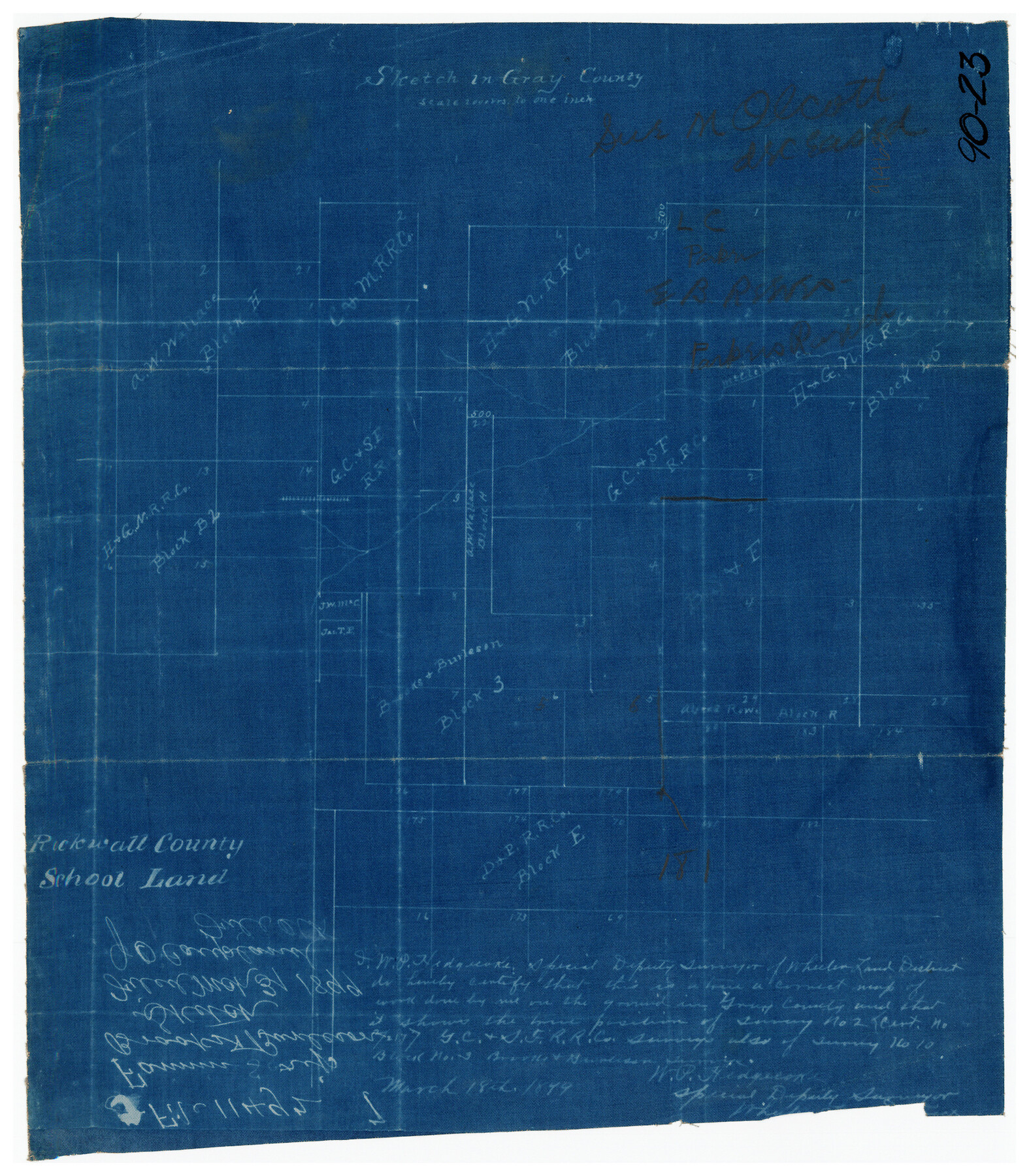
Sketch in Gray County
90-23
-
Map/Doc
90659
-
Collection
Twichell Survey Records
-
Object Dates
1899/18/3 (Creation Date)
-
People and Organizations
W.P. Hedgecoke (Surveyor/Engineer)
-
Counties
Gray
-
Height x Width
10.2 x 11.6 inches
25.9 x 29.5 cm
Part of: Twichell Survey Records
Sketch of Part of Crockett County, Texas

Print $20.00
- Digital $50.00
Sketch of Part of Crockett County, Texas
1925
Size 20.0 x 18.0 inches
Map/Doc 92545
Gulf Coast Oil Fields

Print $2.00
- Digital $50.00
Gulf Coast Oil Fields
Size 12.6 x 8.1 inches
Map/Doc 90135
[E. L. & R. R. Block 10]
![91353, [E. L. & R. R. Block 10], Twichell Survey Records](https://historictexasmaps.com/wmedia_w700/maps/91353-1.tif.jpg)
Print $20.00
- Digital $50.00
[E. L. & R. R. Block 10]
Size 25.3 x 16.5 inches
Map/Doc 91353
[Sketch showing details along East line of Lipscomb County]
![89968, [Sketch showing details along East line of Lipscomb County], Twichell Survey Records](https://historictexasmaps.com/wmedia_w700/maps/89968-1.tif.jpg)
Print $40.00
- Digital $50.00
[Sketch showing details along East line of Lipscomb County]
Size 9.9 x 66.3 inches
Map/Doc 89968
[Blocks C-3, A-2, 29, GG and I]
![91612, [Blocks C-3, A-2, 29, GG and I], Twichell Survey Records](https://historictexasmaps.com/wmedia_w700/maps/91612-1.tif.jpg)
Print $20.00
- Digital $50.00
[Blocks C-3, A-2, 29, GG and I]
Size 26.0 x 18.8 inches
Map/Doc 91612
[Brooks & Burleson Blocks 2 and 4, Capitol Leagues and other surveys and Blocks in vicinity]
![90645, [Brooks & Burleson Blocks 2 and 4, Capitol Leagues and other surveys and Blocks in vicinity], Twichell Survey Records](https://historictexasmaps.com/wmedia_w700/maps/90645-1.tif.jpg)
Print $20.00
- Digital $50.00
[Brooks & Burleson Blocks 2 and 4, Capitol Leagues and other surveys and Blocks in vicinity]
1903
Size 22.6 x 35.6 inches
Map/Doc 90645
D. B. Gardner vs. Mrs. Clara C. Starr

Print $20.00
- Digital $50.00
D. B. Gardner vs. Mrs. Clara C. Starr
Size 16.3 x 28.5 inches
Map/Doc 91044
[North line of Sherman, Hansford, Ochiltree and Lipscomb Counties]
![93189, [North line of Sherman, Hansford, Ochiltree and Lipscomb Counties], Twichell Survey Records](https://historictexasmaps.com/wmedia_w700/maps/93189-1.tif.jpg)
Print $40.00
- Digital $50.00
[North line of Sherman, Hansford, Ochiltree and Lipscomb Counties]
Size 127.0 x 14.3 inches
Map/Doc 93189
[East half of Crockett County]
![92997, [East half of Crockett County], Twichell Survey Records](https://historictexasmaps.com/wmedia_w700/maps/92997-1.tif.jpg)
Print $20.00
- Digital $50.00
[East half of Crockett County]
Size 15.2 x 21.9 inches
Map/Doc 92997
[Map showing J. H. Gibson Blocks D and DD]
![92006, [Map showing J. H. Gibson Blocks D and DD], Twichell Survey Records](https://historictexasmaps.com/wmedia_w700/maps/92006-1.tif.jpg)
Print $20.00
- Digital $50.00
[Map showing J. H. Gibson Blocks D and DD]
Size 31.5 x 22.0 inches
Map/Doc 92006
[Texas & Pacific Block 32, T-4-N showing ties to triangulation stations]
![90142, [Texas & Pacific Block 32, T-4-N showing ties to triangulation stations], Twichell Survey Records](https://historictexasmaps.com/wmedia_w700/maps/90142-1.tif.jpg)
Print $20.00
- Digital $50.00
[Texas & Pacific Block 32, T-4-N showing ties to triangulation stations]
Size 20.4 x 11.6 inches
Map/Doc 90142
![93119, [Capitol Lands], Twichell Survey Records](https://historictexasmaps.com/wmedia_w700/maps/93119-1.tif.jpg)
You may also like
Shelby County Sketch File 23

Print $5.00
- Digital $50.00
Shelby County Sketch File 23
Size 16.2 x 7.3 inches
Map/Doc 36645
Coke County Boundary File 6

Print $62.00
- Digital $50.00
Coke County Boundary File 6
Size 7.2 x 37.9 inches
Map/Doc 51615
City and Harbor of Port Arthur Texas, Bird's Eye View Looking South to the Gulf of Mexico

Print $20.00
City and Harbor of Port Arthur Texas, Bird's Eye View Looking South to the Gulf of Mexico
1912
Size 17.4 x 39.9 inches
Map/Doc 93483
Hutchinson County Working Sketch 47

Print $20.00
- Digital $50.00
Hutchinson County Working Sketch 47
1980
Size 35.2 x 19.9 inches
Map/Doc 66407
Copy of a portion of Arista's map

Print $20.00
- Digital $50.00
Copy of a portion of Arista's map
1847
Size 27.5 x 18.3 inches
Map/Doc 73057
Flight Mission No. CGI-3N, Frame 47, Cameron County

Print $20.00
- Digital $50.00
Flight Mission No. CGI-3N, Frame 47, Cameron County
1954
Size 18.7 x 22.3 inches
Map/Doc 84553
Flight Mission No. DCL-7C, Frame 20, Kenedy County

Print $20.00
- Digital $50.00
Flight Mission No. DCL-7C, Frame 20, Kenedy County
1943
Size 15.5 x 15.1 inches
Map/Doc 86012
Midland County Working Sketch 19a

Print $20.00
- Digital $50.00
Midland County Working Sketch 19a
Size 20.2 x 23.4 inches
Map/Doc 71000

San Luis Pass to East Matagorda Bay

Print $20.00
- Digital $50.00
San Luis Pass to East Matagorda Bay
1957
Size 34.9 x 46.9 inches
Map/Doc 69962
Crockett County Sketch File 9

Print $12.00
- Digital $50.00
Crockett County Sketch File 9
1881
Size 9.0 x 10.0 inches
Map/Doc 19655
Hidalgo County Working Sketch 6

Print $20.00
- Digital $50.00
Hidalgo County Working Sketch 6
1960
Size 21.4 x 20.4 inches
Map/Doc 66183