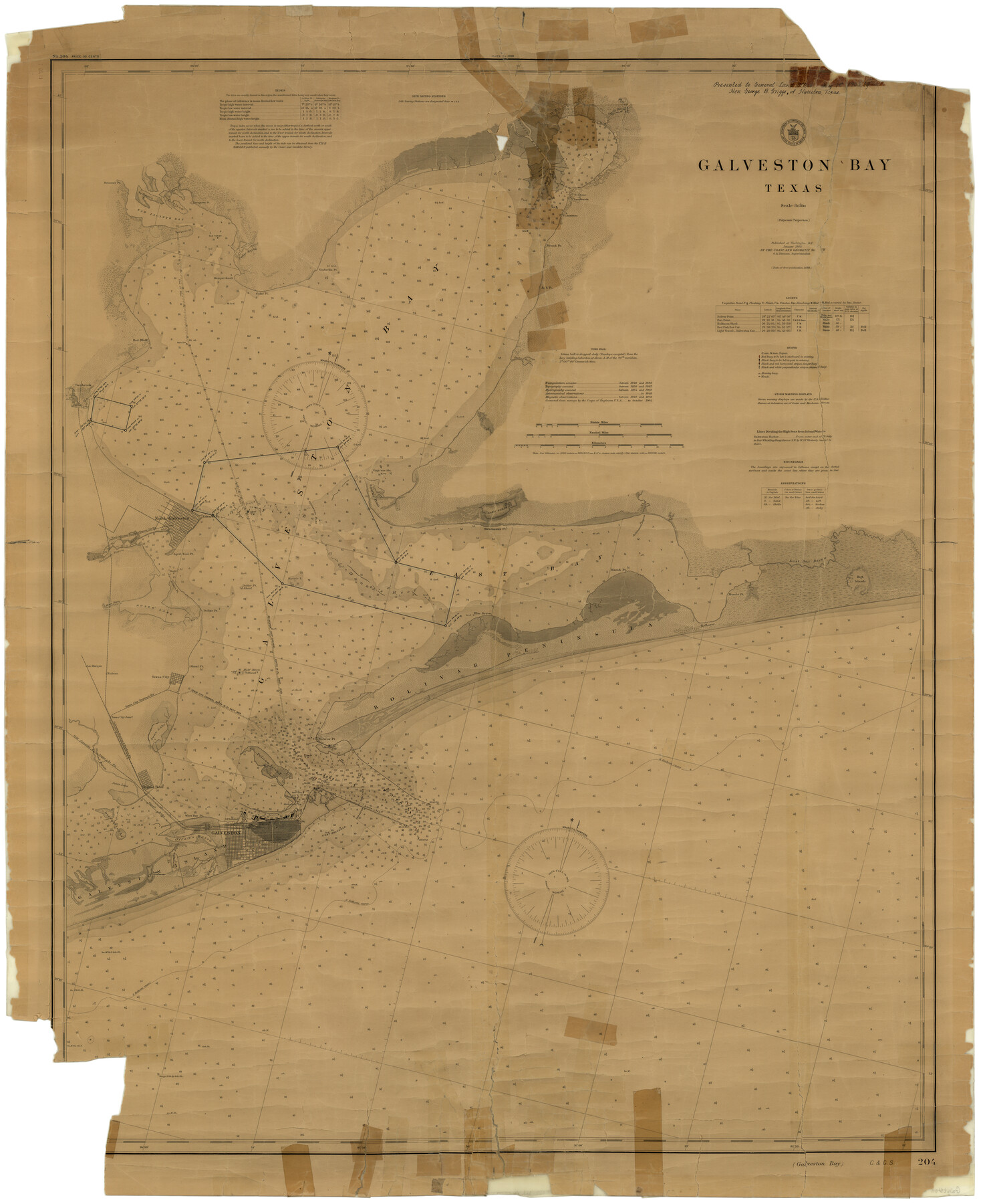
Galveston County Rolled Sketch 9
Galveston Bay, Texas
N-1-45
-
Map/Doc
9090
-
Collection
General Map Collection
-
Object Dates
1/1905 (Creation Date)
5/1/1905 (File Date)
-
People and Organizations
Coast and Geodetic Survey (Publisher)
George B. Griggs (Donor)
-
Counties
Galveston
-
Subjects
Surveying Rolled Sketch
-
Height x Width
45.2 x 37.2 inches
114.8 x 94.5 cm
-
Medium
paper, etching/engraving/lithograph
-
Comments
"Presented to General Land Office, May 1, 1905 by Hon. George B. Griggs of Houston, Texas". Partially adopted by Crew Land Research and Friends of the Texas General Land Office. Conservation funded in 2005.
Part of: General Map Collection

Cameron County Rolled Sketch 7A

Print $20.00
- Digital $50.00
Cameron County Rolled Sketch 7A
1926
Size 30.2 x 34.0 inches
Map/Doc 5384
[Sketch for Mineral Application 26501 - Sabine River, T. A. Oldhausen]
![2843, [Sketch for Mineral Application 26501 - Sabine River, T. A. Oldhausen], General Map Collection](https://historictexasmaps.com/wmedia_w700/maps/2843.tif.jpg)
Print $20.00
- Digital $50.00
[Sketch for Mineral Application 26501 - Sabine River, T. A. Oldhausen]
1931
Size 23.8 x 36.2 inches
Map/Doc 2843
Jasper County Sketch File 16

Print $20.00
- Digital $50.00
Jasper County Sketch File 16
Size 16.8 x 16.2 inches
Map/Doc 11849
Sabine County Boundary File 1

Print $96.00
- Digital $50.00
Sabine County Boundary File 1
Size 14.4 x 8.8 inches
Map/Doc 58530
Nueces County Sketch File 27

Print $56.00
- Digital $50.00
Nueces County Sketch File 27
1907
Size 11.1 x 8.7 inches
Map/Doc 32588
Map of Cherokee Co.

Print $40.00
- Digital $50.00
Map of Cherokee Co.
1902
Size 49.6 x 39.7 inches
Map/Doc 4908
Colorado River, Twin Basin Sheet

Print $6.00
- Digital $50.00
Colorado River, Twin Basin Sheet
1941
Size 27.2 x 35.1 inches
Map/Doc 65317
Webb County Rolled Sketch 13

Print $20.00
- Digital $50.00
Webb County Rolled Sketch 13
Size 17.6 x 33.8 inches
Map/Doc 8177
Flight Mission No. DAH-9M, Frame 86, Orange County

Print $20.00
- Digital $50.00
Flight Mission No. DAH-9M, Frame 86, Orange County
1953
Size 18.4 x 22.2 inches
Map/Doc 86850
Flight Mission No. CRE-2R, Frame 164, Jackson County

Print $20.00
- Digital $50.00
Flight Mission No. CRE-2R, Frame 164, Jackson County
1956
Size 18.5 x 22.2 inches
Map/Doc 85374
Live Oak County Working Sketch 31

Print $20.00
- Digital $50.00
Live Oak County Working Sketch 31
1991
Size 22.8 x 25.4 inches
Map/Doc 70616
You may also like
Texas Intracoastal Waterway, Aransas Bay to Aransas Pass

Print $20.00
- Digital $50.00
Texas Intracoastal Waterway, Aransas Bay to Aransas Pass
1962
Size 26.8 x 38.7 inches
Map/Doc 73438
Throckmorton County, Texas

Print $20.00
- Digital $50.00
Throckmorton County, Texas
1880
Size 28.8 x 22.5 inches
Map/Doc 627
Flight Mission No. CLL-1N, Frame 18, Willacy County

Print $20.00
- Digital $50.00
Flight Mission No. CLL-1N, Frame 18, Willacy County
1954
Size 18.3 x 22.1 inches
Map/Doc 87005
Marion County Working Sketch 12

Print $20.00
- Digital $50.00
Marion County Working Sketch 12
1952
Size 24.5 x 34.2 inches
Map/Doc 70787
Dickens County Working Sketch 12
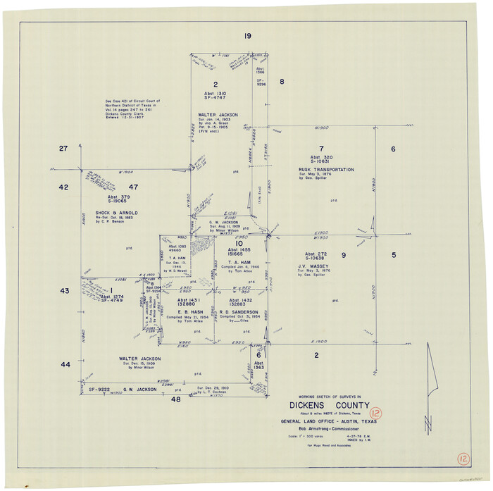
Print $20.00
- Digital $50.00
Dickens County Working Sketch 12
1978
Size 28.3 x 28.9 inches
Map/Doc 68660

Galveston County NRC Article 33.136 Sketch 69

Print $76.00
- Digital $50.00
Galveston County NRC Article 33.136 Sketch 69
2012
Size 24.0 x 36.0 inches
Map/Doc 94669
Aransas County NRC Article 33.136 Sketch 19

Print $66.00
- Digital $50.00
Aransas County NRC Article 33.136 Sketch 19
2022
Map/Doc 96898

Sketch showing position of Asylum Lands Blk. 4, H. & T. C. R.R. Co. & river surveys on north side of Middle Concho, Tom Green Co.

Print $20.00
- Digital $50.00
Sketch showing position of Asylum Lands Blk. 4, H. & T. C. R.R. Co. & river surveys on north side of Middle Concho, Tom Green Co.
Size 14.4 x 20.6 inches
Map/Doc 388
Gonzales County Working Sketch 4a

Print $20.00
- Digital $50.00
Gonzales County Working Sketch 4a
1979
Size 30.9 x 32.2 inches
Map/Doc 63219
Franklin County Boundary File 1

Print $8.00
- Digital $50.00
Franklin County Boundary File 1
Size 12.9 x 8.1 inches
Map/Doc 53569