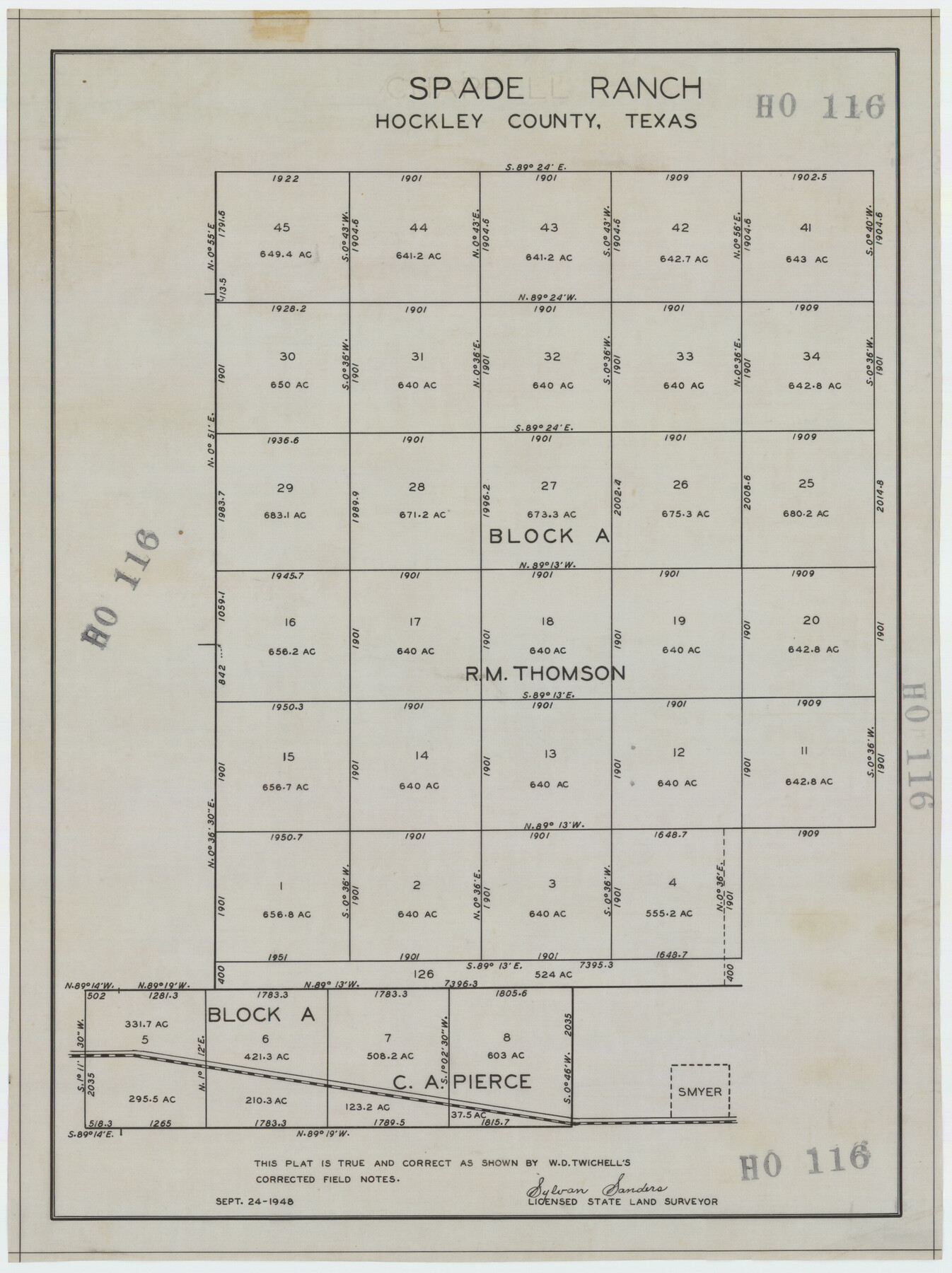
Spade Ranch Hockley County, Texas
HO116
-
Map/Doc
92225
-
Collection
Twichell Survey Records
-
Object Dates
9/24/1948 (Creation Date)
-
People and Organizations
Sylvan Sanders (Surveyor/Engineer)
-
Counties
Hockley
-
Height x Width
14.2 x 19.0 inches
36.1 x 48.3 cm
Part of: Twichell Survey Records
S. F. Singleton's Lands Sold to H. B. Herd, Located in Southwest Part of Lynn County

Print $20.00
- Digital $50.00
S. F. Singleton's Lands Sold to H. B. Herd, Located in Southwest Part of Lynn County
1908
Size 12.1 x 23.1 inches
Map/Doc 91339

Ed. F. Mann's Subdivision of Stephens County School Land, Crosby County, Texas

Print $20.00
- Digital $50.00
Ed. F. Mann's Subdivision of Stephens County School Land, Crosby County, Texas
Size 19.2 x 22.3 inches
Map/Doc 90356
[Surveys around the Martha Barker survey]
![90235, [Surveys around the Martha Barker survey], Twichell Survey Records](https://historictexasmaps.com/wmedia_w700/maps/90235-1.tif.jpg)
Print $20.00
- Digital $50.00
[Surveys around the Martha Barker survey]
Size 26.8 x 20.2 inches
Map/Doc 90235
[Blocks T1, T2, and T3]
![90995, [Blocks T1, T2, and T3], Twichell Survey Records](https://historictexasmaps.com/wmedia_w700/maps/90995-1.tif.jpg)
Print $20.00
- Digital $50.00
[Blocks T1, T2, and T3]
1888
Size 16.0 x 25.9 inches
Map/Doc 90995
[John W. Carpenter and Surrounding Surveys]
![91085, [John W. Carpenter and Surrounding Surveys], Twichell Survey Records](https://historictexasmaps.com/wmedia_w700/maps/91085-1.tif.jpg)
Print $20.00
- Digital $50.00
[John W. Carpenter and Surrounding Surveys]
1922
Size 17.7 x 29.6 inches
Map/Doc 91085
Sketch of Surveys in Crosby and Garza Cos.

Print $20.00
- Digital $50.00
Sketch of Surveys in Crosby and Garza Cos.
Size 19.7 x 25.3 inches
Map/Doc 90338
[Blk. Y2, B. & B. Blk. 5, T. T. Blk. T, North line of H. & G. N. Blk. 4]
![90140, [Blk. Y2, B. & B. Blk. 5, T. T. Blk. T, North line of H. & G. N. Blk. 4], Twichell Survey Records](https://historictexasmaps.com/wmedia_w700/maps/90140-1.tif.jpg)
Print $20.00
- Digital $50.00
[Blk. Y2, B. & B. Blk. 5, T. T. Blk. T, North line of H. & G. N. Blk. 4]
Size 18.8 x 23.7 inches
Map/Doc 90140
Deaf Smith County, Texas

Print $20.00
- Digital $50.00
Deaf Smith County, Texas
Size 24.7 x 18.8 inches
Map/Doc 90596
[Texas and Pacific Railway Company, Block 44, Township One South]
![89846, [Texas and Pacific Railway Company, Block 44, Township One South], Twichell Survey Records](https://historictexasmaps.com/wmedia_w700/maps/89846-1.tif.jpg)
Print $40.00
- Digital $50.00
[Texas and Pacific Railway Company, Block 44, Township One South]
1912
Size 41.1 x 56.4 inches
Map/Doc 89846
J. W. Kendrick Land, Crosby County, Texas

Print $20.00
- Digital $50.00
J. W. Kendrick Land, Crosby County, Texas
Size 42.8 x 33.7 inches
Map/Doc 92603
Map of Pecos County, Texas

Print $20.00
- Digital $50.00
Map of Pecos County, Texas
Size 18.9 x 22.8 inches
Map/Doc 91573
You may also like
Harris County Sketch File 30

Print $21.00
- Digital $50.00
Harris County Sketch File 30
Size 11.3 x 8.5 inches
Map/Doc 25416
Navarro County Sketch File 20

Print $14.00
- Digital $50.00
Navarro County Sketch File 20
1967
Size 14.3 x 8.8 inches
Map/Doc 32343
Flight Mission No. DAG-14K, Frame 132, Matagorda County

Print $20.00
- Digital $50.00
Flight Mission No. DAG-14K, Frame 132, Matagorda County
1952
Size 17.6 x 17.5 inches
Map/Doc 86303
Leon County Sketch File 30

Print $6.00
- Digital $50.00
Leon County Sketch File 30
1951
Size 11.2 x 8.7 inches
Map/Doc 29829
Harris County Historic Topographic 24

Print $20.00
- Digital $50.00
Harris County Historic Topographic 24
1916
Size 29.2 x 22.9 inches
Map/Doc 65835
Archer County

Print $20.00
- Digital $50.00
Archer County
1898
Size 36.0 x 39.4 inches
Map/Doc 93033
Upton County Rolled Sketch 36

Print $40.00
- Digital $50.00
Upton County Rolled Sketch 36
1952
Size 42.9 x 64.2 inches
Map/Doc 10051
Delta County Sketch File 5

Print $2.00
- Digital $50.00
Delta County Sketch File 5
1886
Size 14.6 x 8.6 inches
Map/Doc 20676
Glasscock County Rolled Sketch 10

Print $20.00
- Digital $50.00
Glasscock County Rolled Sketch 10
Size 47.6 x 45.9 inches
Map/Doc 9058
Jefferson County Rolled Sketch 38

Print $20.00
- Digital $50.00
Jefferson County Rolled Sketch 38
1957
Size 33.8 x 31.5 inches
Map/Doc 6397
Sketch K Showing the Progress of the Survey of the Columbia River, Oregon

Print $20.00
- Digital $50.00
Sketch K Showing the Progress of the Survey of the Columbia River, Oregon
1852
Size 9.8 x 12.7 inches
Map/Doc 97237
The Republic County of Shelby. December 29, 1845

Print $20.00
The Republic County of Shelby. December 29, 1845
2020
Size 20.0 x 21.7 inches
Map/Doc 96288