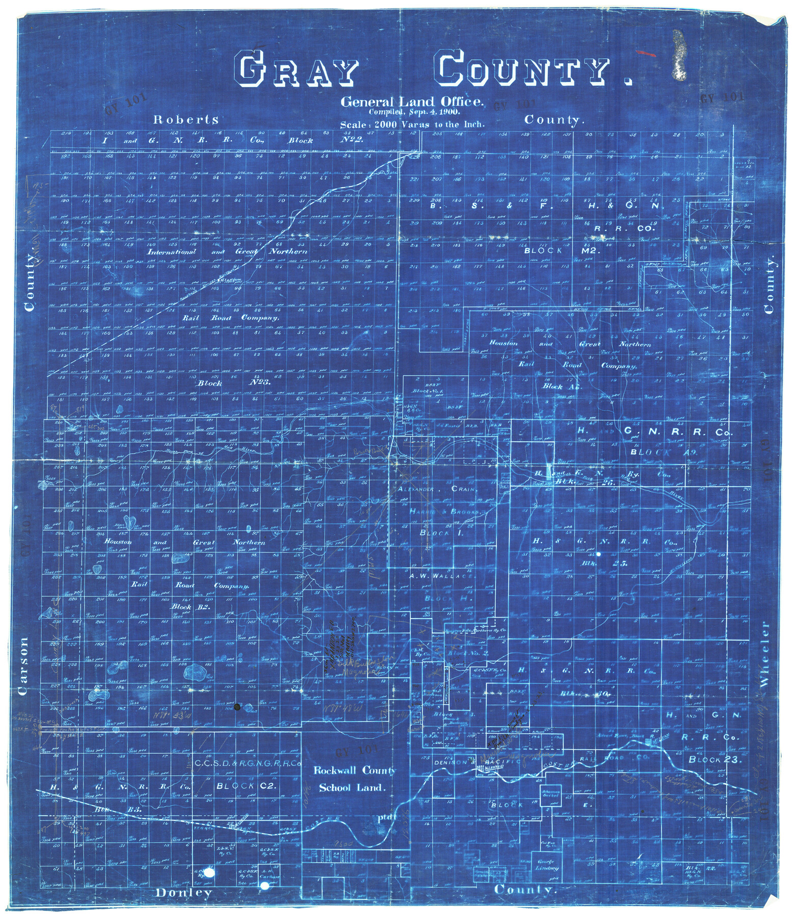
Gray County
-
Map/Doc
92897
-
Collection
Twichell Survey Records
-
Object Dates
9/4/1900 (Creation Date)
-
Counties
Gray
-
Subjects
County
-
Height x Width
23.0 x 26.5 inches
58.4 x 67.3 cm
Part of: Twichell Survey Records
[Corner of Crosby, Lubbock, Lynn and Garza Counties]
![90905, [Corner of Crosby, Lubbock, Lynn and Garza Counties], Twichell Survey Records](https://historictexasmaps.com/wmedia_w700/maps/90905-1.tif.jpg)
Print $20.00
- Digital $50.00
[Corner of Crosby, Lubbock, Lynn and Garza Counties]
Size 36.0 x 22.8 inches
Map/Doc 90905
[Blocks 24, B9, 3KA]
![90326, [Blocks 24, B9, 3KA], Twichell Survey Records](https://historictexasmaps.com/wmedia_w700/maps/90326-1.tif.jpg)
Print $20.00
- Digital $50.00
[Blocks 24, B9, 3KA]
Size 18.2 x 14.0 inches
Map/Doc 90326
D. B. Gardner vs. Mrs. Clara C. Starr

Print $20.00
- Digital $50.00
D. B. Gardner vs. Mrs. Clara C. Starr
Size 16.6 x 30.1 inches
Map/Doc 92148

[E. L. & R. R. Blocks 8, 9, and 10, T. T. R. R. Block 32, J. Poitevent Block 1]
![91351, [E. L. & R. R. Blocks 8, 9, and 10, T. T. R. R. Block 32, J. Poitevent Block 1], Twichell Survey Records](https://historictexasmaps.com/wmedia_w700/maps/91351-1.tif.jpg)
Print $20.00
- Digital $50.00
[E. L. & R. R. Blocks 8, 9, and 10, T. T. R. R. Block 32, J. Poitevent Block 1]
1900
Size 13.8 x 16.8 inches
Map/Doc 91351
Leveland and Adjacent Subdivisions of League 28, Hood County School Land Hockley County, Texas

Print $40.00
- Digital $50.00
Leveland and Adjacent Subdivisions of League 28, Hood County School Land Hockley County, Texas
Size 42.4 x 50.4 inches
Map/Doc 89848
[Leagues 27, 28, 69, 70, 71, 72, and 73]
![91096, [Leagues 27, 28, 69, 70, 71, 72, and 73], Twichell Survey Records](https://historictexasmaps.com/wmedia_w700/maps/91096-1.tif.jpg)
Print $20.00
- Digital $50.00
[Leagues 27, 28, 69, 70, 71, 72, and 73]
Size 24.0 x 15.7 inches
Map/Doc 91096
[Blocks 1 and 2 along River in Motley County]
![91507, [Blocks 1 and 2 along River in Motley County], Twichell Survey Records](https://historictexasmaps.com/wmedia_w700/maps/91507-1.tif.jpg)
Print $20.00
- Digital $50.00
[Blocks 1 and 2 along River in Motley County]
1876
Size 21.3 x 16.6 inches
Map/Doc 91507
[State Line - 103rd Meridian - in relation to Leagues]
![91551, [State Line - 103rd Meridian - in relation to Leagues], Twichell Survey Records](https://historictexasmaps.com/wmedia_w700/maps/91551-2.tif.jpg)
Print $20.00
- Digital $50.00
[State Line - 103rd Meridian - in relation to Leagues]
Size 19.9 x 8.3 inches
Map/Doc 91551
[Subdivision plat of Crockett County School Land Leagues 214-217 and adjacent leagues]
![90253, [Subdivision plat of Crockett County School Land Leagues 214-217 and adjacent leagues], Twichell Survey Records](https://historictexasmaps.com/wmedia_w700/maps/90253-1.tif.jpg)
Print $20.00
- Digital $50.00
[Subdivision plat of Crockett County School Land Leagues 214-217 and adjacent leagues]
Size 26.9 x 19.0 inches
Map/Doc 90253
Tahoka Consolidated Independent School District

Print $20.00
- Digital $50.00
Tahoka Consolidated Independent School District
Size 34.1 x 22.1 inches
Map/Doc 92943
[Nathaniel H. Cochran Survey and Vicinity]
![91498, [Nathaniel H. Cochran Survey and Vicinity], Twichell Survey Records](https://historictexasmaps.com/wmedia_w700/maps/91498-1.tif.jpg)
Print $20.00
- Digital $50.00
[Nathaniel H. Cochran Survey and Vicinity]
Size 25.4 x 18.7 inches
Map/Doc 91498
You may also like
Flight Mission No. CGI-3N, Frame 98, Cameron County

Print $20.00
- Digital $50.00
Flight Mission No. CGI-3N, Frame 98, Cameron County
1954
Size 18.5 x 22.1 inches
Map/Doc 84578
Burnet County Working Sketch 27

Print $20.00
- Digital $50.00
Burnet County Working Sketch 27
2025
Size 24.5 x 36.0 inches
Map/Doc 97419
Leon County Rolled Sketch 36

Print $20.00
- Digital $50.00
Leon County Rolled Sketch 36
Size 18.1 x 24.0 inches
Map/Doc 95352
General Highway Map. Detail of Cities and Towns in Bee County, Texas. City Map of Beeville, Bee County, Texas

Print $20.00
General Highway Map. Detail of Cities and Towns in Bee County, Texas. City Map of Beeville, Bee County, Texas
1961
Size 25.0 x 18.2 inches
Map/Doc 79365
Harris County Working Sketch 67

Print $20.00
- Digital $50.00
Harris County Working Sketch 67
1955
Size 23.3 x 27.5 inches
Map/Doc 65959
Flight Mission No. DQN-3K, Frame 35, Calhoun County

Print $20.00
- Digital $50.00
Flight Mission No. DQN-3K, Frame 35, Calhoun County
1953
Size 16.4 x 16.2 inches
Map/Doc 84348
Red River County Working Sketch 60

Print $20.00
- Digital $50.00
Red River County Working Sketch 60
1973
Size 27.1 x 40.0 inches
Map/Doc 72043
Gillespie County Sketch File 10

Print $4.00
- Digital $50.00
Gillespie County Sketch File 10
1877
Size 8.3 x 12.9 inches
Map/Doc 24147
McMullen County Sketch File 35

Print $10.00
- Digital $50.00
McMullen County Sketch File 35
Size 9.7 x 8.5 inches
Map/Doc 31402
Bandera County Rolled Sketch 6

Print $40.00
- Digital $50.00
Bandera County Rolled Sketch 6
Size 55.8 x 41.1 inches
Map/Doc 8439
San Jacinto County Sketch File 22

Print $136.00
San Jacinto County Sketch File 22
1935
Size 11.3 x 8.7 inches
Map/Doc 35734
[Map of Tom Green County]
![4085, [Map of Tom Green County], General Map Collection](https://historictexasmaps.com/wmedia_w700/maps/4085-2.tif.jpg)
Print $20.00
- Digital $50.00
[Map of Tom Green County]
Size 23.9 x 36.5 inches
Map/Doc 4085