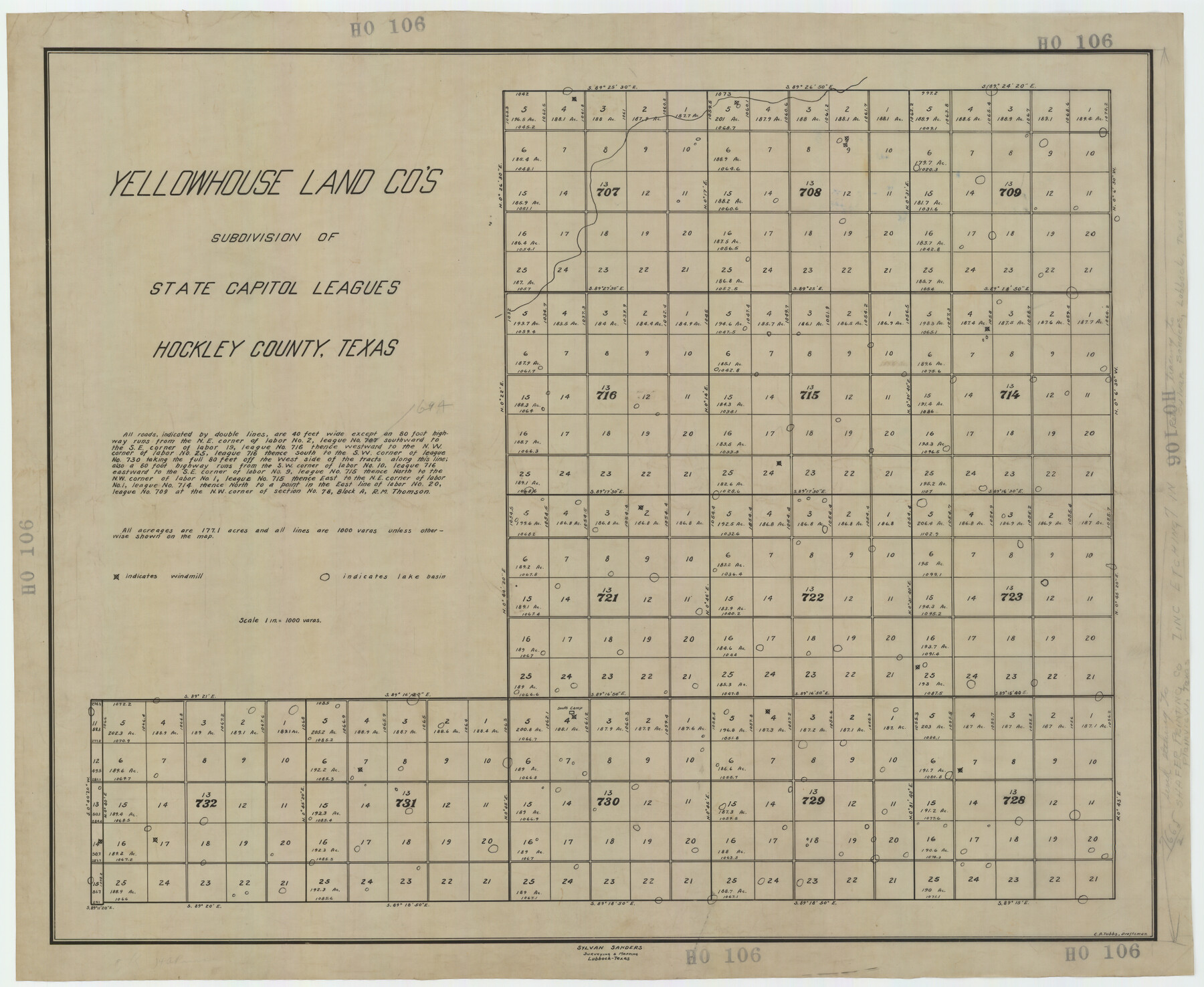
Yellowhouse Land Company's Subdivision of State Capitol Leagues Hockley County, Texas
HO106
-
Map/Doc
92260
-
Collection
Twichell Survey Records
-
People and Organizations
Sylvan Sanders (Surveyor/Engineer)
C.A. Tubbs (Draftsman)
-
Counties
Hockley
-
Height x Width
30.7 x 24.9 inches
78.0 x 63.3 cm
Part of: Twichell Survey Records
[T. T. RR. Co. Block 8 and vicinity]
![90875, [T. T. RR. Co. Block 8 and vicinity], Twichell Survey Records](https://historictexasmaps.com/wmedia_w700/maps/90875-2.tif.jpg)
Print $20.00
- Digital $50.00
[T. T. RR. Co. Block 8 and vicinity]
Size 25.3 x 39.0 inches
Map/Doc 90875
Ater Heights Section 44, Block AK

Print $20.00
- Digital $50.00
Ater Heights Section 44, Block AK
1952
Size 11.9 x 18.9 inches
Map/Doc 92347
![90594, [Block K7], Twichell Survey Records](https://historictexasmaps.com/wmedia_w700/maps/90594-1.tif.jpg)
[Area in the vicinity of the Mary Fury survey south of H. T. & B. RR. Co. surveys 125 and 126]
![90933, [Area in the vicinity of the Mary Fury survey south of H. T. & B. RR. Co. surveys 125 and 126], Twichell Survey Records](https://historictexasmaps.com/wmedia_w700/maps/90933-1.tif.jpg)
Print $20.00
- Digital $50.00
[Area in the vicinity of the Mary Fury survey south of H. T. & B. RR. Co. surveys 125 and 126]
Size 13.5 x 21.7 inches
Map/Doc 90933
Crockett County, Texas

Print $20.00
- Digital $50.00
Crockett County, Texas
Size 24.7 x 19.5 inches
Map/Doc 90316
James Subdivision, NE/4 Section 1, Block E, G. C. & S. F. R.R. Co. Cert 3/360, Abstract 46

Print $20.00
- Digital $50.00
James Subdivision, NE/4 Section 1, Block E, G. C. & S. F. R.R. Co. Cert 3/360, Abstract 46
Size 17.8 x 19.4 inches
Map/Doc 92734
[H. & T. C. RR. Company Block 47, Sections 46, 47, 48, and 49]
![91220, [H. & T. C. RR. Company Block 47, Sections 46, 47, 48, and 49], Twichell Survey Records](https://historictexasmaps.com/wmedia_w700/maps/91220-1.tif.jpg)
Print $3.00
- Digital $50.00
[H. & T. C. RR. Company Block 47, Sections 46, 47, 48, and 49]
Size 9.4 x 11.4 inches
Map/Doc 91220
[Sketch showing B. S. & F. Block 9 and vicinity]
![89786, [Sketch showing B. S. & F. Block 9 and vicinity], Twichell Survey Records](https://historictexasmaps.com/wmedia_w700/maps/89786-1.tif.jpg)
Print $20.00
- Digital $50.00
[Sketch showing B. S. & F. Block 9 and vicinity]
Size 39.0 x 47.6 inches
Map/Doc 89786
Gray County, Texas

Print $20.00
- Digital $50.00
Gray County, Texas
Size 13.4 x 14.9 inches
Map/Doc 90722
Map of Texas-Mexican Railway Lands in El Paso County, Texas

Print $3.00
- Digital $50.00
Map of Texas-Mexican Railway Lands in El Paso County, Texas
1907
Size 13.7 x 10.8 inches
Map/Doc 91134
[Map of Texas Panhandle Counties and Adjacent New Mexico Counties]
![89906, [Map of Texas Panhandle Counties and Adjacent New Mexico Counties], Twichell Survey Records](https://historictexasmaps.com/wmedia_w700/maps/89906-2.tif.jpg)
Print $40.00
- Digital $50.00
[Map of Texas Panhandle Counties and Adjacent New Mexico Counties]
Size 44.5 x 63.8 inches
Map/Doc 89906
[Blocks M27 and 1T along border with Oklahoma (North line of County)]
![93144, [Blocks M27 and 1T along border with Oklahoma (North line of County)], Twichell Survey Records](https://historictexasmaps.com/wmedia_w700/maps/93144-1.tif.jpg)
Print $40.00
- Digital $50.00
[Blocks M27 and 1T along border with Oklahoma (North line of County)]
Size 107.3 x 8.6 inches
Map/Doc 93144
You may also like

Map of Scurry County

Print $20.00
- Digital $50.00
Map of Scurry County
1899
Size 39.8 x 34.7 inches
Map/Doc 63029
Fisher County Boundary File 1

Print $16.00
- Digital $50.00
Fisher County Boundary File 1
Size 12.8 x 8.4 inches
Map/Doc 53411
Stephens County Sketch File 13

Print $4.00
- Digital $50.00
Stephens County Sketch File 13
Size 11.2 x 8.8 inches
Map/Doc 37063
Flight Mission No. CRC-2R, Frame 185, Chambers County

Print $20.00
- Digital $50.00
Flight Mission No. CRC-2R, Frame 185, Chambers County
1956
Size 18.8 x 22.4 inches
Map/Doc 84763
Flight Mission No. DQN-3K, Frame 37, Calhoun County

Print $20.00
- Digital $50.00
Flight Mission No. DQN-3K, Frame 37, Calhoun County
1953
Size 16.4 x 16.1 inches
Map/Doc 84350
Flight Mission No. DQO-8K, Frame 47, Galveston County

Print $20.00
- Digital $50.00
Flight Mission No. DQO-8K, Frame 47, Galveston County
1952
Size 18.7 x 22.2 inches
Map/Doc 85154
Lamar County State Real Property Sketch 1

Print $20.00
- Digital $50.00
Lamar County State Real Property Sketch 1
2013
Size 24.0 x 36.0 inches
Map/Doc 93656
San Jacinto River, Buff Lake Sheet 1/Caney Creek

Print $20.00
- Digital $50.00
San Jacinto River, Buff Lake Sheet 1/Caney Creek
1937
Size 18.7 x 37.6 inches
Map/Doc 65147
Uvalde County Working Sketch 38

Print $20.00
- Digital $50.00
Uvalde County Working Sketch 38
1970
Size 33.3 x 30.8 inches
Map/Doc 72108
[Sketch showing Block 47, sections 77-108]
![91732, [Sketch showing Block 47, sections 77-108], Twichell Survey Records](https://historictexasmaps.com/wmedia_w700/maps/91732-1.tif.jpg)
Print $20.00
- Digital $50.00
[Sketch showing Block 47, sections 77-108]
1919
Size 20.5 x 34.1 inches
Map/Doc 91732
General Highway Map, Winkler County, Texas

Print $20.00
General Highway Map, Winkler County, Texas
1961
Size 18.2 x 24.8 inches
Map/Doc 79716