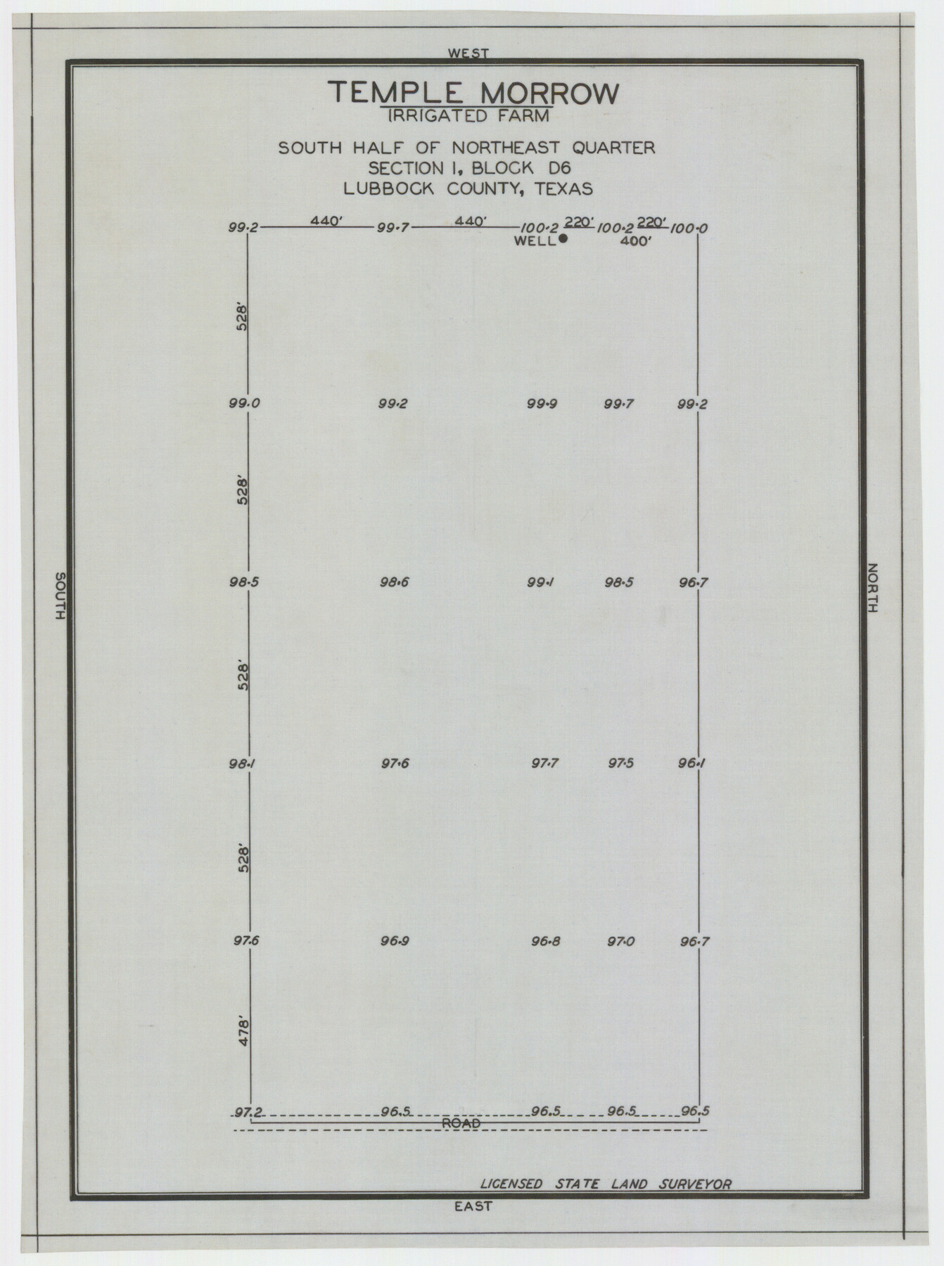
Temple Morrow Irrigated Farm South Half of Section 1, Block D6
-
Map/Doc
92311
-
Collection
Twichell Survey Records
-
Counties
Lubbock
-
Height x Width
9.5 x 12.8 inches
24.1 x 32.5 cm
Part of: Twichell Survey Records
[Sketch showing Blocks M-20 and M-22]
![91722, [Sketch showing Blocks M-20 and M-22], Twichell Survey Records](https://historictexasmaps.com/wmedia_w700/maps/91722-1.tif.jpg)
Print $20.00
- Digital $50.00
[Sketch showing Blocks M-20 and M-22]
Size 15.0 x 19.5 inches
Map/Doc 91722
Sketch Showing Original Corners and Connections affecting Blocks T1, T2, and T3 in Lamb and Castro Counties, Texas

Print $20.00
- Digital $50.00
Sketch Showing Original Corners and Connections affecting Blocks T1, T2, and T3 in Lamb and Castro Counties, Texas
Size 17.3 x 29.1 inches
Map/Doc 92982
College Park Addition to the City of Lubbock Located on Section 9, Block B

Print $20.00
- Digital $50.00
College Park Addition to the City of Lubbock Located on Section 9, Block B
Size 12.9 x 15.9 inches
Map/Doc 92277
Andrews County Block A-46

Print $20.00
- Digital $50.00
Andrews County Block A-46
Size 23.4 x 15.3 inches
Map/Doc 92638
[H. & G. N. RR. Co. Block 1]
![90888, [H. & G. N. RR. Co. Block 1], Twichell Survey Records](https://historictexasmaps.com/wmedia_w700/maps/90888-1.tif.jpg)
Print $20.00
- Digital $50.00
[H. & G. N. RR. Co. Block 1]
Size 37.1 x 43.6 inches
Map/Doc 90888
Wilda Stewart Farm, Crosby County, Texas

Print $20.00
- Digital $50.00
Wilda Stewart Farm, Crosby County, Texas
1949
Size 20.5 x 20.4 inches
Map/Doc 92599
[H. & G. N. Block 1]
![90939, [H. & G. N. Block 1], Twichell Survey Records](https://historictexasmaps.com/wmedia_w700/maps/90939-1.tif.jpg)
Print $20.00
- Digital $50.00
[H. & G. N. Block 1]
1902
Size 13.5 x 16.4 inches
Map/Doc 90939
J. N. Watson Subdivision of Blocks 1, 6, 7, and 43, Lamesa, Texas

Print $20.00
- Digital $50.00
J. N. Watson Subdivision of Blocks 1, 6, 7, and 43, Lamesa, Texas
Size 11.6 x 24.8 inches
Map/Doc 92574
[West half of county, south of John H. Stephens Block S2]
![90976, [West half of county, south of John H. Stephens Block S2], Twichell Survey Records](https://historictexasmaps.com/wmedia_w700/maps/90976-1.tif.jpg)
Print $2.00
- Digital $50.00
[West half of county, south of John H. Stephens Block S2]
Size 11.8 x 8.7 inches
Map/Doc 90976
[West Central Portion of County]
![91257, [West Central Portion of County], Twichell Survey Records](https://historictexasmaps.com/wmedia_w700/maps/91257-1.tif.jpg)
Print $20.00
- Digital $50.00
[West Central Portion of County]
Size 19.5 x 9.8 inches
Map/Doc 91257
[Madison County School Land, W. Perry and other surveys to the East]
![90429, [Madison County School Land, W. Perry and other surveys to the East], Twichell Survey Records](https://historictexasmaps.com/wmedia_w700/maps/90429-1.tif.jpg)
Print $20.00
- Digital $50.00
[Madison County School Land, W. Perry and other surveys to the East]
Size 13.8 x 16.3 inches
Map/Doc 90429
[Sketch Showing Wm. T. Brewer, John R. Taylor, Wm. F. Butler, Timothy DeVore, L. M. Thorn and adjoining surveys]
![90231, [Sketch Showing Wm. T. Brewer, John R. Taylor, Wm. F. Butler, Timothy DeVore, L. M. Thorn and adjoining surveys], Twichell Survey Records](https://historictexasmaps.com/wmedia_w700/maps/90231-1.tif.jpg)
Print $20.00
- Digital $50.00
[Sketch Showing Wm. T. Brewer, John R. Taylor, Wm. F. Butler, Timothy DeVore, L. M. Thorn and adjoining surveys]
Size 27.2 x 19.4 inches
Map/Doc 90231
You may also like
Mexican Boundary B. - Extract from the Treaty Map of Disturnell of 1847 referred to in Col. Graham's report to the Hon. The Secretary of the Interior of Aug. 16th, 1851

Print $20.00
- Digital $50.00
Mexican Boundary B. - Extract from the Treaty Map of Disturnell of 1847 referred to in Col. Graham's report to the Hon. The Secretary of the Interior of Aug. 16th, 1851
1851
Size 10.1 x 16.5 inches
Map/Doc 96525
[Part of Map Showing Terry & Lynn County Line Highlighting Parts of Blocks D8, E, 9]
![92264, [Part of Map Showing Terry & Lynn County Line Highlighting Parts of Blocks D8, E, 9], Twichell Survey Records](https://historictexasmaps.com/wmedia_w700/maps/92264-1.tif.jpg)
Print $20.00
- Digital $50.00
[Part of Map Showing Terry & Lynn County Line Highlighting Parts of Blocks D8, E, 9]
Size 18.2 x 10.9 inches
Map/Doc 92264
Block 32, Township 4 North

Print $20.00
- Digital $50.00
Block 32, Township 4 North
Size 17.5 x 25.3 inches
Map/Doc 92507
Descripción y Mapa de la Nueva Provincia, poblada de Bárbaros, situada en la Costa del Seno Mexicano, desde el puerto de Tampico hasta la Provincia de Texas

Descripción y Mapa de la Nueva Provincia, poblada de Bárbaros, situada en la Costa del Seno Mexicano, desde el puerto de Tampico hasta la Provincia de Texas
1744
Size 32.0 x 29.1 inches
Map/Doc 94558
Bosque County Sketch File 2

Print $4.00
- Digital $50.00
Bosque County Sketch File 2
1847
Size 7.8 x 12.4 inches
Map/Doc 14740
Flight Mission No. CGI-4N, Frame 161, Cameron County

Print $20.00
- Digital $50.00
Flight Mission No. CGI-4N, Frame 161, Cameron County
1955
Size 18.7 x 22.4 inches
Map/Doc 84669
Flight Mission No. BRE-3P, Frame 78, Nueces County

Print $20.00
- Digital $50.00
Flight Mission No. BRE-3P, Frame 78, Nueces County
1956
Size 18.5 x 22.2 inches
Map/Doc 86819
Map of Hardin County

Print $20.00
- Digital $50.00
Map of Hardin County
1902
Size 43.8 x 42.3 inches
Map/Doc 4699
Millennium in Maps - Exploration

Millennium in Maps - Exploration
Size 20.6 x 31.5 inches
Map/Doc 95931
[Block 1, Section 31]
![92171, [Block 1, Section 31], Twichell Survey Records](https://historictexasmaps.com/wmedia_w700/maps/92171-1.tif.jpg)
Print $20.00
- Digital $50.00
[Block 1, Section 31]
1946
Size 24.3 x 19.7 inches
Map/Doc 92171
Harris County Sketch File 77

Print $26.00
- Digital $50.00
Harris County Sketch File 77
1953
Size 11.3 x 8.8 inches
Map/Doc 25546
Brewster County Sketch File N-28

Print $40.00
- Digital $50.00
Brewster County Sketch File N-28
Size 23.4 x 24.3 inches
Map/Doc 10973