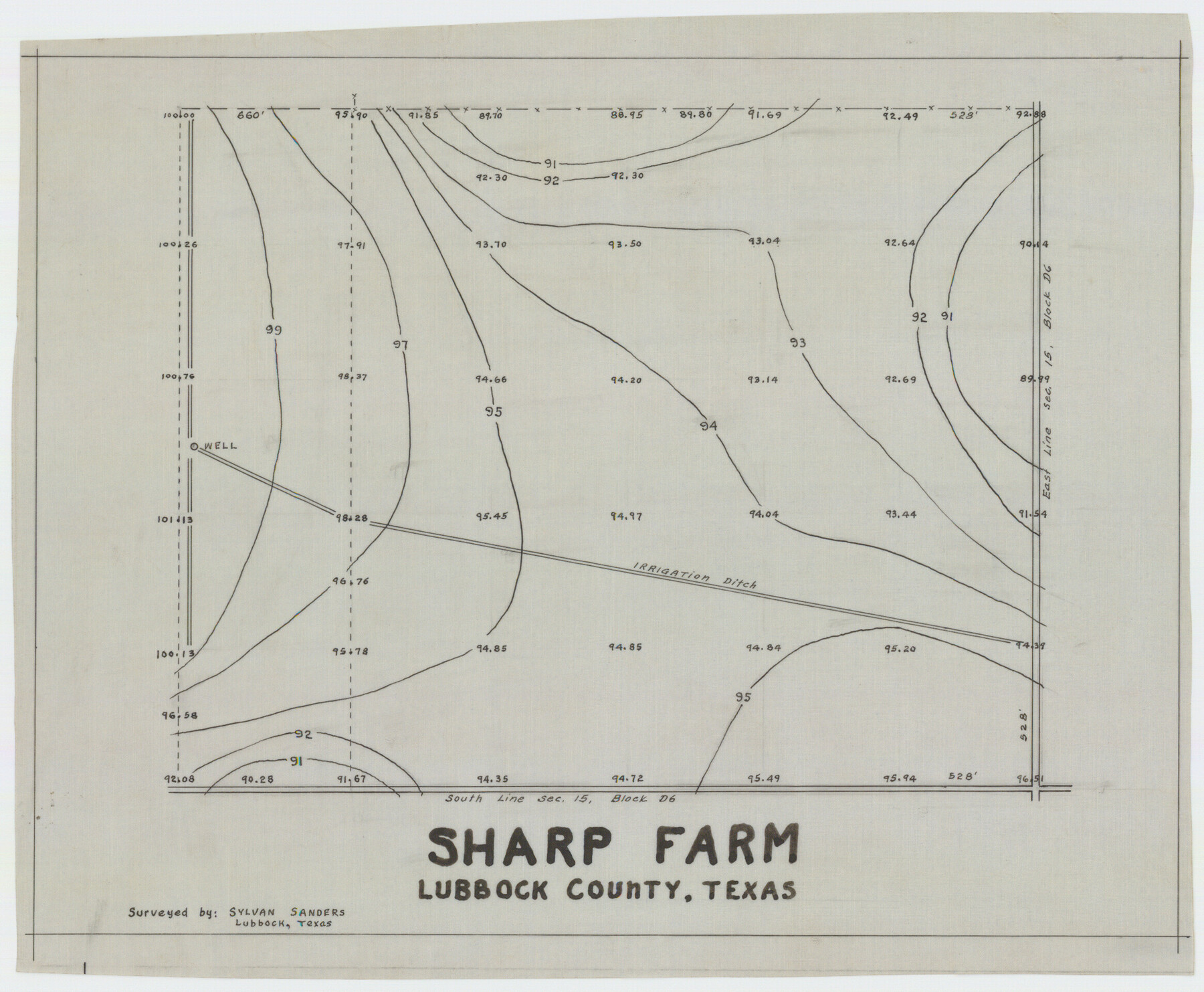
Sharp Farm
-
Map/Doc
92333
-
Collection
Twichell Survey Records
-
People and Organizations
Sylvan Sanders (Surveyor/Engineer)
-
Counties
Lubbock
-
Height x Width
11.9 x 9.8 inches
30.2 x 24.9 cm
Part of: Twichell Survey Records
League 206 Ochiltree County School Land

Print $20.00
- Digital $50.00
League 206 Ochiltree County School Land
Size 24.0 x 19.5 inches
Map/Doc 92481
[Jones County School Land, Blocks P, D, D6, and CB]
![91091, [Jones County School Land, Blocks P, D, D6, and CB], Twichell Survey Records](https://historictexasmaps.com/wmedia_w700/maps/91091-1.tif.jpg)
Print $2.00
- Digital $50.00
[Jones County School Land, Blocks P, D, D6, and CB]
1907
Size 8.0 x 14.5 inches
Map/Doc 91091
[Blocks 34 and 35, Township 4N]
![92030, [Blocks 34 and 35, Township 4N], Twichell Survey Records](https://historictexasmaps.com/wmedia_w700/maps/92030-1.tif.jpg)
Print $20.00
- Digital $50.00
[Blocks 34 and 35, Township 4N]
Size 24.6 x 23.6 inches
Map/Doc 92030
[University Lands Block 16 and Blocks 194, Z and part of 12]
![91618, [University Lands Block 16 and Blocks 194, Z and part of 12], Twichell Survey Records](https://historictexasmaps.com/wmedia_w700/maps/91618-1.tif.jpg)
Print $20.00
- Digital $50.00
[University Lands Block 16 and Blocks 194, Z and part of 12]
1911
Size 32.2 x 23.3 inches
Map/Doc 91618
Part of P. S. L. Blks. B-15 & B-16 - W. D. Twichell Corners

Print $20.00
- Digital $50.00
Part of P. S. L. Blks. B-15 & B-16 - W. D. Twichell Corners
1938
Size 36.7 x 24.8 inches
Map/Doc 90844
Sketch Showing all that Portion of Block 24 North of Santa Fe R. R. Right-of-Way in Original Town of Lubbock

Print $20.00
- Digital $50.00
Sketch Showing all that Portion of Block 24 North of Santa Fe R. R. Right-of-Way in Original Town of Lubbock
1925
Size 26.9 x 34.4 inches
Map/Doc 92809

[Leagues 464-467 and vicinity]
![91559, [Leagues 464-467 and vicinity], Twichell Survey Records](https://historictexasmaps.com/wmedia_w700/maps/91559-1.tif.jpg)
Print $20.00
- Digital $50.00
[Leagues 464-467 and vicinity]
Size 18.4 x 12.1 inches
Map/Doc 91559
[Eastern part of Culberson County]
![90505, [Eastern part of Culberson County], Twichell Survey Records](https://historictexasmaps.com/wmedia_w700/maps/90505-1.tif.jpg)
Print $20.00
- Digital $50.00
[Eastern part of Culberson County]
Size 29.0 x 40.5 inches
Map/Doc 90505
[Northwest part of County]
![90865, [Northwest part of County], Twichell Survey Records](https://historictexasmaps.com/wmedia_w700/maps/90865-2.tif.jpg)
Print $20.00
- Digital $50.00
[Northwest part of County]
Size 32.3 x 22.3 inches
Map/Doc 90865
Leila Y. Post Montgomery & Marjorie Post Hutton's Subdivision of Hall County School Land Leagues 158-159-N 1/2 157, Cochran County, Texas

Print $20.00
- Digital $50.00
Leila Y. Post Montgomery & Marjorie Post Hutton's Subdivision of Hall County School Land Leagues 158-159-N 1/2 157, Cochran County, Texas
Size 8.4 x 18.4 inches
Map/Doc 90456
[Yates, just south of Runnels County School Land]
![91653, [Yates, just south of Runnels County School Land], Twichell Survey Records](https://historictexasmaps.com/wmedia_w700/maps/91653-1.tif.jpg)
Print $20.00
- Digital $50.00
[Yates, just south of Runnels County School Land]
1928
Size 17.7 x 22.7 inches
Map/Doc 91653
You may also like
Liberty County Working Sketch 55

Print $20.00
- Digital $50.00
Liberty County Working Sketch 55
1962
Size 30.4 x 31.4 inches
Map/Doc 70515
Cooke County Working Sketch 29

Print $20.00
- Digital $50.00
Cooke County Working Sketch 29
1977
Size 28.7 x 35.0 inches
Map/Doc 68266
Johnson County Working Sketch 14

Print $20.00
- Digital $50.00
Johnson County Working Sketch 14
1974
Size 37.3 x 31.7 inches
Map/Doc 66627
Plat of surveys in El Paso Co. made for Maddox Bro's & Anderson and Gunter & Munson

Print $20.00
- Digital $50.00
Plat of surveys in El Paso Co. made for Maddox Bro's & Anderson and Gunter & Munson
Size 22.2 x 23.4 inches
Map/Doc 713
Right of Way & Track Map San Antonio & Aransas Pass Railway Co.

Print $40.00
- Digital $50.00
Right of Way & Track Map San Antonio & Aransas Pass Railway Co.
1919
Size 25.3 x 56.5 inches
Map/Doc 64024
[Yates survey 34 1/2 and vicinity]
![91690, [Yates survey 34 1/2 and vicinity], Twichell Survey Records](https://historictexasmaps.com/wmedia_w700/maps/91690-1.tif.jpg)
Print $20.00
- Digital $50.00
[Yates survey 34 1/2 and vicinity]
Size 12.6 x 17.7 inches
Map/Doc 91690
Township No. 5 South Range No. 9 West of the Indian Meridian

Print $20.00
- Digital $50.00
Township No. 5 South Range No. 9 West of the Indian Meridian
1874
Size 19.2 x 24.4 inches
Map/Doc 75167
Duval County Rolled Sketch 16

Print $20.00
- Digital $50.00
Duval County Rolled Sketch 16
1940
Size 45.3 x 34.8 inches
Map/Doc 8810
Panola County Working Sketch 7

Print $20.00
- Digital $50.00
Panola County Working Sketch 7
1942
Map/Doc 71416
Witt Addition, Subdivision out of Section 6, Block E, City of Lubbock

Print $20.00
- Digital $50.00
Witt Addition, Subdivision out of Section 6, Block E, City of Lubbock
1950
Size 9.1 x 30.9 inches
Map/Doc 92739
Mapa de los Estados Unidos de Méjico, Segun lo organizado y definido por las varias actas del Congreso de dicha Republica: y construido por las mejores autoridades

Print $20.00
Mapa de los Estados Unidos de Méjico, Segun lo organizado y definido por las varias actas del Congreso de dicha Republica: y construido por las mejores autoridades
1846
Size 30.8 x 42.4 inches
Map/Doc 79727
Map of Portion of the Gulf of Mexico Adjoining Jefferson County Showing Subdivision Thereof for Mineral Development

Print $20.00
- Digital $50.00
Map of Portion of the Gulf of Mexico Adjoining Jefferson County Showing Subdivision Thereof for Mineral Development
1940
Size 17.7 x 20.2 inches
Map/Doc 3018