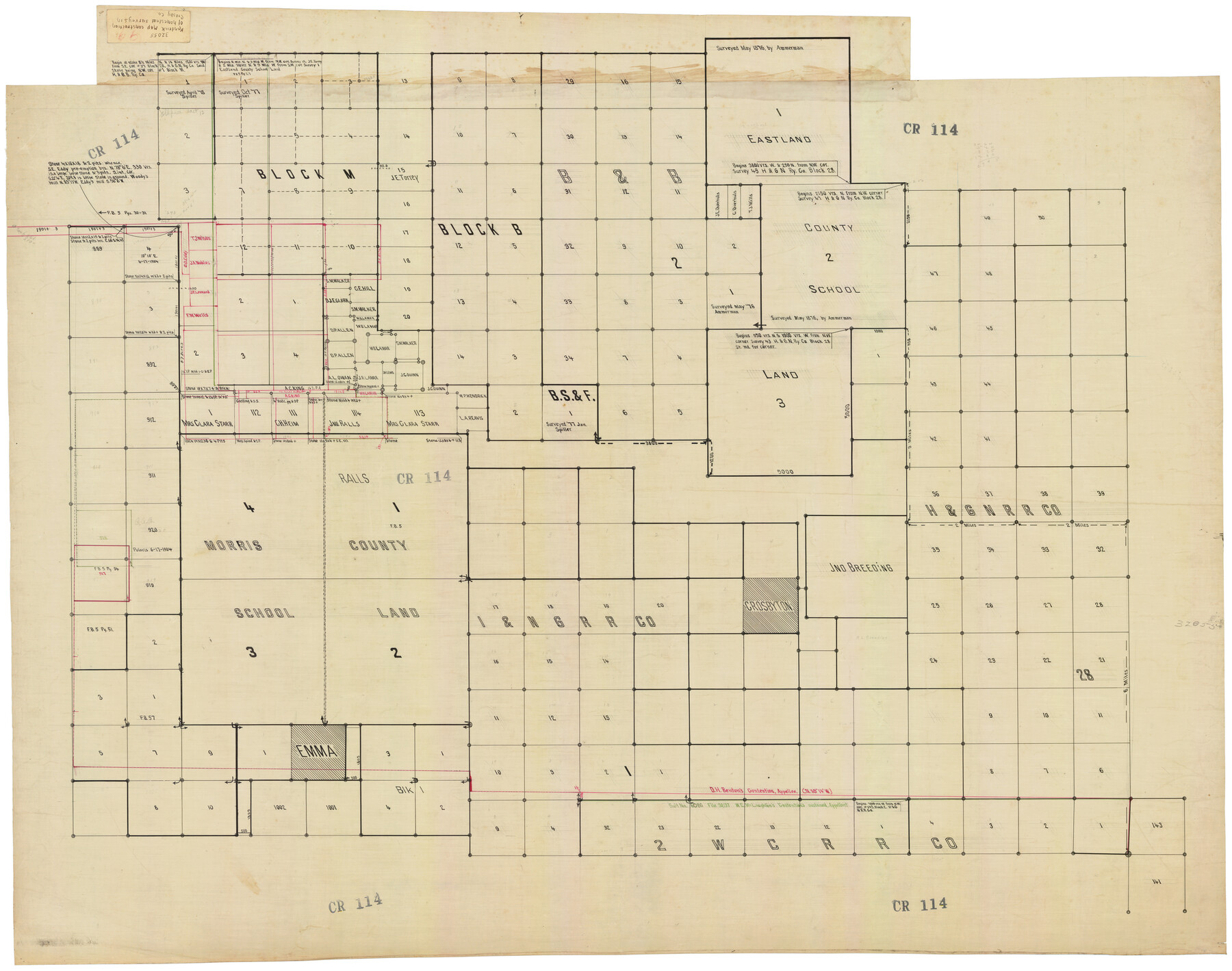
J. W. Kendrick Land, Crosby County, Texas
CR114
-
Map/Doc
92604
-
Collection
Twichell Survey Records
-
Counties
Crosby
-
Height x Width
43.1 x 33.8 inches
109.5 x 85.9 cm
Part of: Twichell Survey Records
[Sketch of part of G. & M. Block 5]
![93077, [Sketch of part of G. & M. Block 5], Twichell Survey Records](https://historictexasmaps.com/wmedia_w700/maps/93077-1.tif.jpg)
Print $3.00
- Digital $50.00
[Sketch of part of G. & M. Block 5]
Size 17.7 x 9.4 inches
Map/Doc 93077
John Slaughter Ranch

Print $40.00
- Digital $50.00
John Slaughter Ranch
Size 38.0 x 52.7 inches
Map/Doc 89952
Lamb County, Texas Compiled by Sylvan Sanders Lubbock, Texas

Print $20.00
- Digital $50.00
Lamb County, Texas Compiled by Sylvan Sanders Lubbock, Texas
Size 24.0 x 27.2 inches
Map/Doc 92200
[Jose Ostane survey]
![89983, [Jose Ostane survey], Twichell Survey Records](https://historictexasmaps.com/wmedia_w700/maps/89983-1.tif.jpg)
Print $3.00
- Digital $50.00
[Jose Ostane survey]
Size 14.6 x 9.3 inches
Map/Doc 89983
[Map showing J. H. Gibson Blocks D and DD and Double Lake Corner]
![91996, [Map showing J. H. Gibson Blocks D and DD and Double Lake Corner], Twichell Survey Records](https://historictexasmaps.com/wmedia_w700/maps/91996-1.tif.jpg)
Print $20.00
- Digital $50.00
[Map showing J. H. Gibson Blocks D and DD and Double Lake Corner]
Size 31.3 x 15.9 inches
Map/Doc 91996
Thomas Kelly Subdivision in Parmer and Castro Counties, Texas

Print $20.00
- Digital $50.00
Thomas Kelly Subdivision in Parmer and Castro Counties, Texas
1906
Size 20.4 x 16.6 inches
Map/Doc 92549

[Portion of sketch showing alleged vacancy]
![91953, [Portion of sketch showing alleged vacancy], Twichell Survey Records](https://historictexasmaps.com/wmedia_w700/maps/91953-1.tif.jpg)
Print $20.00
- Digital $50.00
[Portion of sketch showing alleged vacancy]
Size 18.9 x 24.4 inches
Map/Doc 91953
[Pencil sketch and calculations regarding section 34, Block 194]
![91663, [Pencil sketch and calculations regarding section 34, Block 194], Twichell Survey Records](https://historictexasmaps.com/wmedia_w700/maps/91663-1.tif.jpg)
Print $20.00
- Digital $50.00
[Pencil sketch and calculations regarding section 34, Block 194]
Size 23.0 x 12.1 inches
Map/Doc 91663
Working Sketch Bastrop County

Print $20.00
- Digital $50.00
Working Sketch Bastrop County
1923
Size 17.0 x 13.1 inches
Map/Doc 90145
Holmes' Addition Located on North Part of SW Quarter Section 10, Block A

Print $20.00
- Digital $50.00
Holmes' Addition Located on North Part of SW Quarter Section 10, Block A
Size 20.7 x 8.5 inches
Map/Doc 92714
[H. & T. C. Blocks 1 and 2]
![91049, [H. & T. C. Blocks 1 and 2], Twichell Survey Records](https://historictexasmaps.com/wmedia_w700/maps/91049-1.tif.jpg)
Print $3.00
- Digital $50.00
[H. & T. C. Blocks 1 and 2]
Size 13.3 x 11.7 inches
Map/Doc 91049
You may also like
[Sketch of Surveys in Cottle, Dickens, King & Motley Counties, Texas]
![75830, [Sketch of Surveys in Cottle, Dickens, King & Motley Counties, Texas], Maddox Collection](https://historictexasmaps.com/wmedia_w700/maps/75830.tif.jpg)
Print $20.00
- Digital $50.00
[Sketch of Surveys in Cottle, Dickens, King & Motley Counties, Texas]
1913
Size 29.6 x 23.2 inches
Map/Doc 75830
Atascosa County Sketch File 9

Print $4.00
- Digital $50.00
Atascosa County Sketch File 9
1858
Size 8.1 x 12.6 inches
Map/Doc 13763
Atascosa County Boundary File 4

Print $80.00
- Digital $50.00
Atascosa County Boundary File 4
Size 30.6 x 59.2 inches
Map/Doc 50177
Hale County Working Sketch 2

Print $20.00
- Digital $50.00
Hale County Working Sketch 2
1916
Size 13.5 x 13.1 inches
Map/Doc 63322
Williamson County Sketch File 18

Print $6.00
- Digital $50.00
Williamson County Sketch File 18
1871
Size 12.8 x 8.1 inches
Map/Doc 40342
Webb County Sketch File LM3

Print $20.00
- Digital $50.00
Webb County Sketch File LM3
1924
Size 24.7 x 31.9 inches
Map/Doc 12658
Bell County Sketch File 16

Print $4.00
- Digital $50.00
Bell County Sketch File 16
1862
Size 12.0 x 8.3 inches
Map/Doc 14396
Flight Mission No. DQO-2K, Frame 146, Galveston County

Print $20.00
- Digital $50.00
Flight Mission No. DQO-2K, Frame 146, Galveston County
1952
Size 18.7 x 22.4 inches
Map/Doc 85043
Current Miscellaneous File 117

Print $8.00
- Digital $50.00
Current Miscellaneous File 117
2001
Size 11.2 x 8.8 inches
Map/Doc 74823
Gregg County Boundary File 4

Print $14.00
- Digital $50.00
Gregg County Boundary File 4
Size 14.1 x 8.6 inches
Map/Doc 53992
Foard County Working Sketch 10

Print $20.00
- Digital $50.00
Foard County Working Sketch 10
1977
Size 32.0 x 43.7 inches
Map/Doc 69201
Trinity County Sketch File 36

Print $20.00
- Digital $50.00
Trinity County Sketch File 36
Size 43.4 x 18.1 inches
Map/Doc 10408