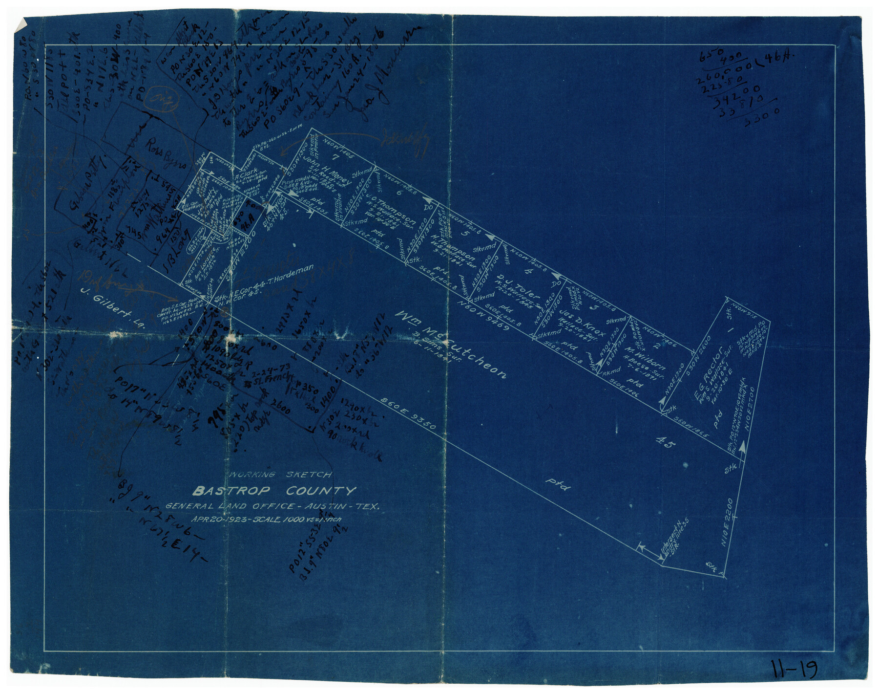
Working Sketch Bastrop County
11-19
-
Map/Doc
90145
-
Collection
Twichell Survey Records
-
Object Dates
4/20/1923 (Creation Date)
-
People and Organizations
General Land Office (Publisher)
-
Counties
Bastrop
-
Height x Width
17.0 x 13.1 inches
43.2 x 33.3 cm
Part of: Twichell Survey Records
[Sketch in Hartley County]
![90770, [Sketch in Hartley County], Twichell Survey Records](https://historictexasmaps.com/wmedia_w700/maps/90770-1.tif.jpg)
Print $20.00
- Digital $50.00
[Sketch in Hartley County]
Size 29.1 x 21.7 inches
Map/Doc 90770
SW/4 of County, B.S.& F. Bk. M-10, J.W.Woodburn Bk.B-1 & G.C.&S.F. Bk.BIGN

Print $20.00
- Digital $50.00
SW/4 of County, B.S.& F. Bk. M-10, J.W.Woodburn Bk.B-1 & G.C.&S.F. Bk.BIGN
Size 34.6 x 27.0 inches
Map/Doc 90266
[City of Lamesa and vicinity]
![92593, [City of Lamesa and vicinity], Twichell Survey Records](https://historictexasmaps.com/wmedia_w700/maps/92593-1.tif.jpg)
Print $20.00
- Digital $50.00
[City of Lamesa and vicinity]
1946
Size 33.9 x 10.5 inches
Map/Doc 92593
S. F. Singleton's Lands Sold to H. B. Herd, Located in Southwest Part of Lynn County

Print $20.00
- Digital $50.00
S. F. Singleton's Lands Sold to H. B. Herd, Located in Southwest Part of Lynn County
1908
Size 12.1 x 23.1 inches
Map/Doc 91339
[Guadalupe College]
![91907, [Guadalupe College], Twichell Survey Records](https://historictexasmaps.com/wmedia_w700/maps/91907-1.tif.jpg)
Print $3.00
- Digital $50.00
[Guadalupe College]
Size 16.7 x 9.7 inches
Map/Doc 91907
[Sketch of counties just south of the Panhandle]
![90913, [Sketch of counties just south of the Panhandle], Twichell Survey Records](https://historictexasmaps.com/wmedia_w700/maps/90913-1.tif.jpg)
Print $20.00
- Digital $50.00
[Sketch of counties just south of the Panhandle]
Size 42.7 x 34.8 inches
Map/Doc 90913

[East line of North Part of Childress County along border with Oklahoma]
![92084, [East line of North Part of Childress County along border with Oklahoma], Twichell Survey Records](https://historictexasmaps.com/wmedia_w700/maps/92084-1.tif.jpg)
Print $20.00
- Digital $50.00
[East line of North Part of Childress County along border with Oklahoma]
Size 20.4 x 6.1 inches
Map/Doc 92084
Sketch File C, Lamb County

Print $20.00
- Digital $50.00
Sketch File C, Lamb County
1904
Size 21.6 x 26.0 inches
Map/Doc 91069
J. O. Jones Land, Gaines County, Texas - Cedar Lake Meridian

Print $20.00
- Digital $50.00
J. O. Jones Land, Gaines County, Texas - Cedar Lake Meridian
Size 8.5 x 32.1 inches
Map/Doc 90792
Resurvey of Block K-3

Print $20.00
- Digital $50.00
Resurvey of Block K-3
1913
Size 17.0 x 19.0 inches
Map/Doc 90540
Map showing lands surveyed by Sylvan Sanders in the Southwestern Part of Jack County, Texas for Buttram Petroleum Corporation

Print $20.00
- Digital $50.00
Map showing lands surveyed by Sylvan Sanders in the Southwestern Part of Jack County, Texas for Buttram Petroleum Corporation
Size 21.2 x 12.9 inches
Map/Doc 92186
You may also like
Hays County Sketch File 31

Print $6.00
- Digital $50.00
Hays County Sketch File 31
1943
Size 14.4 x 8.8 inches
Map/Doc 26261
[Capitol Leagues 633- 664]
![91076, [Capitol Leagues 633- 664], Twichell Survey Records](https://historictexasmaps.com/wmedia_w700/maps/91076-1.tif.jpg)
Print $20.00
- Digital $50.00
[Capitol Leagues 633- 664]
Size 17.0 x 14.6 inches
Map/Doc 91076
Mills County Sketch File 26

Print $4.00
- Digital $50.00
Mills County Sketch File 26
1998
Size 14.3 x 8.8 inches
Map/Doc 31678
Cherokee County Rolled Sketch 2

Print $20.00
- Digital $50.00
Cherokee County Rolled Sketch 2
1954
Size 44.6 x 36.0 inches
Map/Doc 8596
Panola County Working Sketch 4

Print $20.00
- Digital $50.00
Panola County Working Sketch 4
1938
Map/Doc 71413
W. S. Mabry Land Corners and Connections, Potter County

Print $20.00
- Digital $50.00
W. S. Mabry Land Corners and Connections, Potter County
Size 22.4 x 17.4 inches
Map/Doc 91805
Runnels County Working Sketch 21

Print $20.00
- Digital $50.00
Runnels County Working Sketch 21
1951
Size 43.6 x 37.0 inches
Map/Doc 63617
PSL Field Notes for Blocks G, L, P, and Q in Cochran and Yoakum Counties and Blocks U, V, W, Y, and Z in Cochran County

PSL Field Notes for Blocks G, L, P, and Q in Cochran and Yoakum Counties and Blocks U, V, W, Y, and Z in Cochran County
Map/Doc 81645
[H. & G. N. Block 8 showing Llano and Espuella fence lines]
![90374, [H. & G. N. Block 8 showing Llano and Espuella fence lines], Twichell Survey Records](https://historictexasmaps.com/wmedia_w700/maps/90374-1.tif.jpg)
Print $2.00
- Digital $50.00
[H. & G. N. Block 8 showing Llano and Espuella fence lines]
Size 6.2 x 9.7 inches
Map/Doc 90374
Flight Mission No. BRE-2P, Frame 18, Nueces County

Print $20.00
- Digital $50.00
Flight Mission No. BRE-2P, Frame 18, Nueces County
1956
Size 18.5 x 22.7 inches
Map/Doc 86727
Bastrop County Sketch File 1a

Print $4.00
- Digital $50.00
Bastrop County Sketch File 1a
Size 8.4 x 12.8 inches
Map/Doc 14040
Lampasas County Working Sketch 3

Print $20.00
- Digital $50.00
Lampasas County Working Sketch 3
1941
Size 25.0 x 14.6 inches
Map/Doc 70280