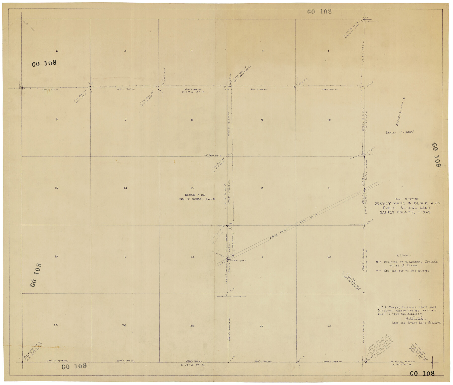
Plat Showing Survey made in Block A-25 Public School Land, Gaines County, Texas
GO108
-
Map/Doc
92656
-
Collection
Twichell Survey Records
-
People and Organizations
C.A. Tubbs (Surveyor/Engineer)
-
Counties
Gaines
-
Height x Width
35.7 x 30.3 inches
90.7 x 77.0 cm
Part of: Twichell Survey Records
[Sketch showing Block H, Section 11 of Roberts County, including the south bank of the Canadian River]
![91761, [Sketch showing Block H, Section 11 of Roberts County, including the south bank of the Canadian River], Twichell Survey Records](https://historictexasmaps.com/wmedia_w700/maps/91761-1.tif.jpg)
Print $2.00
- Digital $50.00
[Sketch showing Block H, Section 11 of Roberts County, including the south bank of the Canadian River]
1919
Size 14.4 x 8.8 inches
Map/Doc 91761
[King, Knox & Stonewall Counties]
![92916, [King, Knox & Stonewall Counties], Twichell Survey Records](https://historictexasmaps.com/wmedia_w700/maps/92916-1.tif.jpg)
Print $20.00
- Digital $50.00
[King, Knox & Stonewall Counties]
1902
Size 19.6 x 28.1 inches
Map/Doc 92916
Sketch Showing all that Portion of Block 24 North of Santa Fe R. R. Right-of-Way in Original Town of Lubbock

Print $20.00
- Digital $50.00
Sketch Showing all that Portion of Block 24 North of Santa Fe R. R. Right-of-Way in Original Town of Lubbock
1925
Size 27.5 x 35.6 inches
Map/Doc 92810
Kent County, 1898

Print $20.00
- Digital $50.00
Kent County, 1898
1898
Size 38.1 x 41.6 inches
Map/Doc 89706
[H. & T. C. RR. Company, Block 47, Sections 47- 52]
![91411, [H. & T. C. RR. Company, Block 47, Sections 47- 52], Twichell Survey Records](https://historictexasmaps.com/wmedia_w700/maps/91411-1.tif.jpg)
Print $2.00
- Digital $50.00
[H. & T. C. RR. Company, Block 47, Sections 47- 52]
Size 8.6 x 11.1 inches
Map/Doc 91411
[I. & G. N, Sections 8-13]
![91047, [I. & G. N, Sections 8-13], Twichell Survey Records](https://historictexasmaps.com/wmedia_w700/maps/91047-1.tif.jpg)
Print $20.00
- Digital $50.00
[I. & G. N, Sections 8-13]
Size 25.2 x 12.1 inches
Map/Doc 91047
[Strip map showing F. W. & D. C. RR. line from New Mexico border to Dallam-Hartley County Line]
![93147, [Strip map showing F. W. & D. C. RR. line from New Mexico border to Dallam-Hartley County Line], Twichell Survey Records](https://historictexasmaps.com/wmedia_w700/maps/93147-1.tif.jpg)
Print $40.00
- Digital $50.00
[Strip map showing F. W. & D. C. RR. line from New Mexico border to Dallam-Hartley County Line]
Size 105.5 x 20.9 inches
Map/Doc 93147
[Mrs. May Vinson Survey]
![91959, [Mrs. May Vinson Survey], Twichell Survey Records](https://historictexasmaps.com/wmedia_w700/maps/91959-1.tif.jpg)
Print $40.00
- Digital $50.00
[Mrs. May Vinson Survey]
Size 48.4 x 21.9 inches
Map/Doc 91959
[South part of Bailey County showing School Leagues]
![92991, [South part of Bailey County showing School Leagues], Twichell Survey Records](https://historictexasmaps.com/wmedia_w700/maps/92991-1.tif.jpg)
Print $2.00
- Digital $50.00
[South part of Bailey County showing School Leagues]
1914
Size 5.9 x 7.6 inches
Map/Doc 92991
[Sketch of Surveys south of League 153]
![90437, [Sketch of Surveys south of League 153], Twichell Survey Records](https://historictexasmaps.com/wmedia_w700/maps/90437-1.tif.jpg)
Print $2.00
- Digital $50.00
[Sketch of Surveys south of League 153]
Size 9.5 x 5.9 inches
Map/Doc 90437
Map of the Fort Worth and Denver City RR., Oldham Co, Texas

Print $40.00
- Digital $50.00
Map of the Fort Worth and Denver City RR., Oldham Co, Texas
1899
Size 117.7 x 20.6 inches
Map/Doc 93183
[Showing west and north line of County]
![90652, [Showing west and north line of County], Twichell Survey Records](https://historictexasmaps.com/wmedia_w700/maps/90652-1.tif.jpg)
Print $20.00
- Digital $50.00
[Showing west and north line of County]
1885
Size 21.3 x 29.0 inches
Map/Doc 90652
You may also like
Harrison County Working Sketch 1

Print $20.00
- Digital $50.00
Harrison County Working Sketch 1
1919
Size 22.6 x 25.6 inches
Map/Doc 66021
Stephens County Sketch File 10b

Print $8.00
- Digital $50.00
Stephens County Sketch File 10b
1890
Size 8.5 x 7.8 inches
Map/Doc 37048
Galveston County Sketch File 48

Print $44.00
- Digital $50.00
Galveston County Sketch File 48
1976
Size 14.3 x 8.8 inches
Map/Doc 23460
El Paso County Boundary File 22

Print $4.00
- Digital $50.00
El Paso County Boundary File 22
Size 13.6 x 8.6 inches
Map/Doc 53216
Upton County Sketch File S

Print $8.00
- Digital $50.00
Upton County Sketch File S
Size 13.4 x 9.1 inches
Map/Doc 38850
Val Verde County Working Sketch 102

Print $20.00
- Digital $50.00
Val Verde County Working Sketch 102
1981
Size 30.2 x 30.3 inches
Map/Doc 72237
Cow Bayou Oil Field, Orange County, Texas

Print $20.00
- Digital $50.00
Cow Bayou Oil Field, Orange County, Texas
Size 24.0 x 18.8 inches
Map/Doc 93016
A Map of the Indian Territory, Northern Texas and New Mexico Showing the Great Western Prairies

Print $20.00
- Digital $50.00
A Map of the Indian Territory, Northern Texas and New Mexico Showing the Great Western Prairies
1844
Size 14.0 x 17.6 inches
Map/Doc 95700
[John P. Rohus and surrounding surveys]
![90975, [John P. Rohus and surrounding surveys], Twichell Survey Records](https://historictexasmaps.com/wmedia_w700/maps/90975-1.tif.jpg)
Print $20.00
- Digital $50.00
[John P. Rohus and surrounding surveys]
Size 26.2 x 20.0 inches
Map/Doc 90975
Marion County Sketch File 15

Print $10.00
- Digital $50.00
Marion County Sketch File 15
1958
Size 14.3 x 8.8 inches
Map/Doc 30585
Flight Mission No. BQR-5K, Frame 66, Brazoria County

Print $20.00
- Digital $50.00
Flight Mission No. BQR-5K, Frame 66, Brazoria County
1952
Size 18.8 x 22.5 inches
Map/Doc 84011
[Part of Eastern Texas RR. Co. Block 1]
![91898, [Part of Eastern Texas RR. Co. Block 1], Twichell Survey Records](https://historictexasmaps.com/wmedia_w700/maps/91898-1.tif.jpg)
Print $20.00
- Digital $50.00
[Part of Eastern Texas RR. Co. Block 1]
Size 21.2 x 12.2 inches
Map/Doc 91898