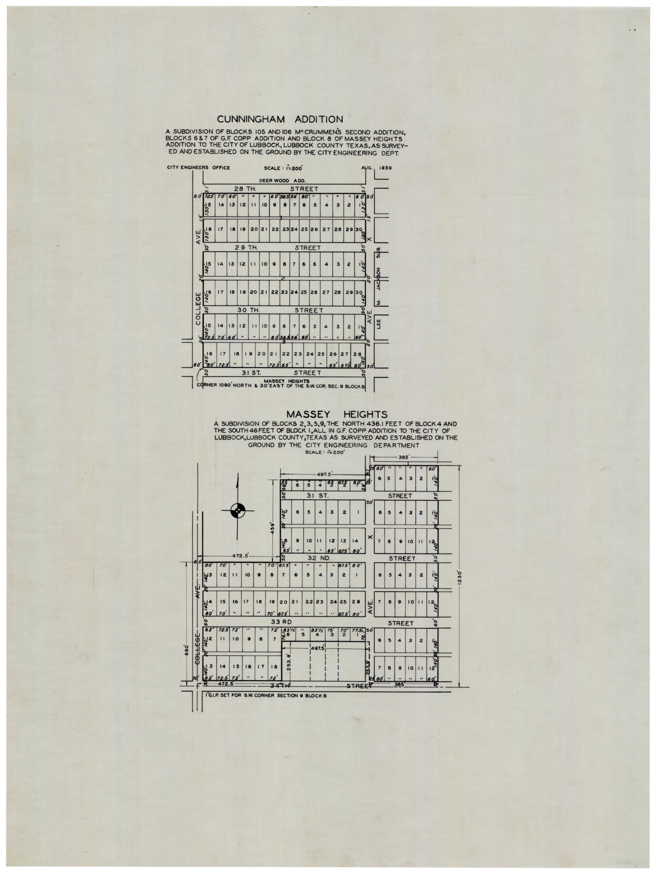
Cunningham Addition and Massey Heights
-
Map/Doc
92744
-
Collection
Twichell Survey Records
-
People and Organizations
Lubbock City Engineering Dept. (Surveyor/Engineer)
-
Counties
Lubbock
-
Height x Width
18.9 x 24.9 inches
48.0 x 63.3 cm
Part of: Twichell Survey Records
[Blocks T2, T3, and K13]
![90997, [Blocks T2, T3, and K13], Twichell Survey Records](https://historictexasmaps.com/wmedia_w700/maps/90997-1.tif.jpg)
Print $20.00
- Digital $50.00
[Blocks T2, T3, and K13]
Size 20.7 x 19.9 inches
Map/Doc 90997
[Part of North line of County, North of Block G]
![90805, [Part of North line of County, North of Block G], Twichell Survey Records](https://historictexasmaps.com/wmedia_w700/maps/90805-1.tif.jpg)
Print $20.00
- Digital $50.00
[Part of North line of County, North of Block G]
Size 17.6 x 12.1 inches
Map/Doc 90805
[Caddo Lake Area]
![91389, [Caddo Lake Area], Twichell Survey Records](https://historictexasmaps.com/wmedia_w700/maps/91389-1.tif.jpg)
Print $20.00
- Digital $50.00
[Caddo Lake Area]
1918
Size 28.4 x 35.3 inches
Map/Doc 91389
South Part Section 55, Block A

Print $20.00
- Digital $50.00
South Part Section 55, Block A
1949
Size 20.3 x 13.0 inches
Map/Doc 92755

Working Sketch in Lubbock and Crosby Cos.

Print $20.00
- Digital $50.00
Working Sketch in Lubbock and Crosby Cos.
1903
Size 35.6 x 26.6 inches
Map/Doc 90504
Sketch in Terry and Yoakum Counties

Print $20.00
- Digital $50.00
Sketch in Terry and Yoakum Counties
1945
Size 20.7 x 38.5 inches
Map/Doc 91939
Subdivision of Tract 2, Soash-White Industrial Addition, Part of Southeast Quarter, Section 2, Block E (Geo. W. Soash - J. B. White, Owners)

Print $20.00
- Digital $50.00
Subdivision of Tract 2, Soash-White Industrial Addition, Part of Southeast Quarter, Section 2, Block E (Geo. W. Soash - J. B. White, Owners)
1956
Size 22.8 x 17.6 inches
Map/Doc 92775
[Sketch of part of county with G.H. & S.A. Blk. 3 on North, H. & T.C. Blk. 4 on West, T. & P. Blk. 1 on South, T. & S. Blks. 224 & 301 on East]
![89958, [Sketch of part of county with G.H. & S.A. Blk. 3 on North, H. & T.C. Blk. 4 on West, T. & P. Blk. 1 on South, T. & S. Blks. 224 & 301 on East], Twichell Survey Records](https://historictexasmaps.com/wmedia_w700/maps/89958-1.tif.jpg)
Print $40.00
- Digital $50.00
[Sketch of part of county with G.H. & S.A. Blk. 3 on North, H. & T.C. Blk. 4 on West, T. & P. Blk. 1 on South, T. & S. Blks. 224 & 301 on East]
Size 51.9 x 37.9 inches
Map/Doc 89958
[H. & G. N. RR. Company, Block 1 and Vicinity]
![91232, [H. & G. N. RR. Company, Block 1 and Vicinity], Twichell Survey Records](https://historictexasmaps.com/wmedia_w700/maps/91232-1.tif.jpg)
Print $20.00
- Digital $50.00
[H. & G. N. RR. Company, Block 1 and Vicinity]
Size 14.1 x 17.7 inches
Map/Doc 91232
[Sketch of surveys around W.T. Brewer]
![89926, [Sketch of surveys around W.T. Brewer], Twichell Survey Records](https://historictexasmaps.com/wmedia_w700/maps/89926-1.tif.jpg)
Print $40.00
- Digital $50.00
[Sketch of surveys around W.T. Brewer]
Size 37.0 x 48.7 inches
Map/Doc 89926
[Blocks D and P]
![92490, [Blocks D and P], Twichell Survey Records](https://historictexasmaps.com/wmedia_w700/maps/92490-1.tif.jpg)
Print $20.00
- Digital $50.00
[Blocks D and P]
Size 41.8 x 29.1 inches
Map/Doc 92490
You may also like
Culberson County Working Sketch 34

Print $20.00
- Digital $50.00
Culberson County Working Sketch 34
1962
Size 35.2 x 26.0 inches
Map/Doc 68487
Reagan County Working Sketch 45

Print $20.00
- Digital $50.00
Reagan County Working Sketch 45
1987
Size 30.1 x 43.1 inches
Map/Doc 71887
Houston County Sketch File 18a

Print $40.00
- Digital $50.00
Houston County Sketch File 18a
Size 12.7 x 15.9 inches
Map/Doc 26783
Motley County Sketch File 4 (S)

Print $4.00
- Digital $50.00
Motley County Sketch File 4 (S)
Size 12.9 x 8.4 inches
Map/Doc 32143
Flight Mission No. CRK-8P, Frame 99, Refugio County

Print $20.00
- Digital $50.00
Flight Mission No. CRK-8P, Frame 99, Refugio County
1956
Size 18.3 x 22.1 inches
Map/Doc 86960
[Surveys in Austin's Colony along New Year's Creek and near the Brazos River]
![218, [Surveys in Austin's Colony along New Year's Creek and near the Brazos River], General Map Collection](https://historictexasmaps.com/wmedia_w700/maps/218.tif.jpg)
Print $20.00
- Digital $50.00
[Surveys in Austin's Colony along New Year's Creek and near the Brazos River]
1821
Size 17.4 x 14.9 inches
Map/Doc 218
Dickens County Sketch File 3

Print $6.00
- Digital $50.00
Dickens County Sketch File 3
1880
Size 6.9 x 6.4 inches
Map/Doc 20959
Houston County Sketch File 42

Print $6.00
- Digital $50.00
Houston County Sketch File 42
1846
Size 11.5 x 9.5 inches
Map/Doc 26830
Lipscomb County Boundary File 6

Print $4.00
- Digital $50.00
Lipscomb County Boundary File 6
Size 11.1 x 8.6 inches
Map/Doc 56329
DeWitt County Sketch File 1

Print $11.00
- Digital $50.00
DeWitt County Sketch File 1
1851
Size 8.4 x 8.2 inches
Map/Doc 20794
Rio Grande Rectification Project, El Paso and Juarez Valley

Print $20.00
- Digital $50.00
Rio Grande Rectification Project, El Paso and Juarez Valley
1935
Size 11.0 x 29.6 inches
Map/Doc 60871
Flight Mission No. CRC-4R, Frame 172, Chambers County

Print $20.00
- Digital $50.00
Flight Mission No. CRC-4R, Frame 172, Chambers County
1956
Size 18.6 x 22.3 inches
Map/Doc 84923