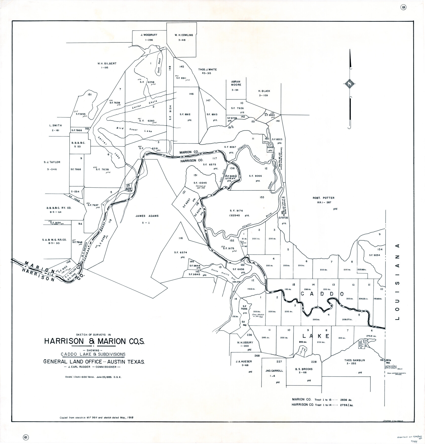
Sketch of surveys in Harrison & Marion Cos. Showing Caddo Lake & Subdivisions
-
Map/Doc
93284
-
Collection
General Map Collection
-
Object Dates
1955/6/20 (Creation Date)
-
People and Organizations
O.G.K. (Draftsman)
-
Counties
Harrison Marion
-
Height x Width
33.8 x 32.4 inches
85.9 x 82.3 cm
-
Medium
mylar, rolled
-
Scale
600 varas
-
Comments
Copied from sketch in MF 964 and sketch (Map # 93283) dated May, 1918.
Part of: General Map Collection
Kendall County Working Sketch 19

Print $20.00
- Digital $50.00
Kendall County Working Sketch 19
1970
Size 31.5 x 33.4 inches
Map/Doc 66691
Stonewall County Sketch File 24

Print $6.00
- Digital $50.00
Stonewall County Sketch File 24
1951
Size 24.8 x 35.2 inches
Map/Doc 12369
Terrell County Working Sketch 25

Print $40.00
- Digital $50.00
Terrell County Working Sketch 25
1942
Size 41.9 x 49.1 inches
Map/Doc 62175
Flight Mission No. BRA-7M, Frame 84, Jefferson County

Print $20.00
- Digital $50.00
Flight Mission No. BRA-7M, Frame 84, Jefferson County
1953
Size 18.6 x 22.3 inches
Map/Doc 85506
Rusk County Sketch File 17

Print $22.00
Rusk County Sketch File 17
1857
Size 12.7 x 15.7 inches
Map/Doc 35520
Maps of Gulf Intracoastal Waterway, Texas - Sabine River to the Rio Grande and connecting waterways including ship channels

Print $20.00
- Digital $50.00
Maps of Gulf Intracoastal Waterway, Texas - Sabine River to the Rio Grande and connecting waterways including ship channels
1966
Size 15.7 x 22.0 inches
Map/Doc 61985
Jack County Working Sketch 20

Print $20.00
- Digital $50.00
Jack County Working Sketch 20
1991
Size 35.4 x 28.9 inches
Map/Doc 66446
Clason's Guide Map of Texas

Print $20.00
- Digital $50.00
Clason's Guide Map of Texas
1919
Size 22.4 x 24.5 inches
Map/Doc 97157
Rand McNally Standard Map of Texas

Rand McNally Standard Map of Texas
1930
Size 34.6 x 28.0 inches
Map/Doc 2147
Jackson County Rolled Sketch 5

Print $20.00
- Digital $50.00
Jackson County Rolled Sketch 5
1914
Size 22.3 x 20.2 inches
Map/Doc 6340
Terrell County Rolled Sketch 58

Print $40.00
- Digital $50.00
Terrell County Rolled Sketch 58
1931
Size 49.1 x 41.8 inches
Map/Doc 9993
Flight Mission No. BQY-4M, Frame 115, Harris County

Print $20.00
- Digital $50.00
Flight Mission No. BQY-4M, Frame 115, Harris County
1953
Size 18.6 x 22.5 inches
Map/Doc 85282
You may also like
Pecos County Rolled Sketch 87

Print $20.00
- Digital $50.00
Pecos County Rolled Sketch 87
1933
Size 37.7 x 27.2 inches
Map/Doc 7244
Frio County Working Sketch 18

Print $20.00
- Digital $50.00
Frio County Working Sketch 18
1982
Size 35.7 x 36.8 inches
Map/Doc 69292
General Highway Map. Detail of Cities and Towns in Bowie County, Texas

Print $20.00
General Highway Map. Detail of Cities and Towns in Bowie County, Texas
1961
Size 18.0 x 24.8 inches
Map/Doc 79381
Brewster County Working Sketch Graphic Index, East Part, Sheet 2 (Sketches 112 to Most Recent)

Print $40.00
- Digital $50.00
Brewster County Working Sketch Graphic Index, East Part, Sheet 2 (Sketches 112 to Most Recent)
1952
Size 48.1 x 30.5 inches
Map/Doc 76477
[Triangulation Net of Part of Texas. Travis County to Red River]
![3101, [Triangulation Net of Part of Texas. Travis County to Red River], General Map Collection](https://historictexasmaps.com/wmedia_w700/maps/3101.tif.jpg)
Print $20.00
- Digital $50.00
[Triangulation Net of Part of Texas. Travis County to Red River]
1928
Size 28.2 x 33.9 inches
Map/Doc 3101

Presidio County Working Sketch 73

Print $20.00
- Digital $50.00
Presidio County Working Sketch 73
1962
Size 17.7 x 29.4 inches
Map/Doc 71750
Stephens County Working Sketch 26

Print $20.00
- Digital $50.00
Stephens County Working Sketch 26
1976
Size 36.9 x 32.2 inches
Map/Doc 63969
Flight Mission No. DQO-1K, Frame 89, Galveston County

Print $20.00
- Digital $50.00
Flight Mission No. DQO-1K, Frame 89, Galveston County
1952
Size 18.9 x 22.5 inches
Map/Doc 84985

Nueces County Sketch File 58

Print $162.00
- Digital $50.00
Nueces County Sketch File 58
1981
Size 11.2 x 8.5 inches
Map/Doc 32920
Sketch of the Designation of Route of the Aransas Channel Harbor & Dock Company's Deep Water Channel

Print $3.00
- Digital $50.00
Sketch of the Designation of Route of the Aransas Channel Harbor & Dock Company's Deep Water Channel
Size 13.2 x 10.0 inches
Map/Doc 4495