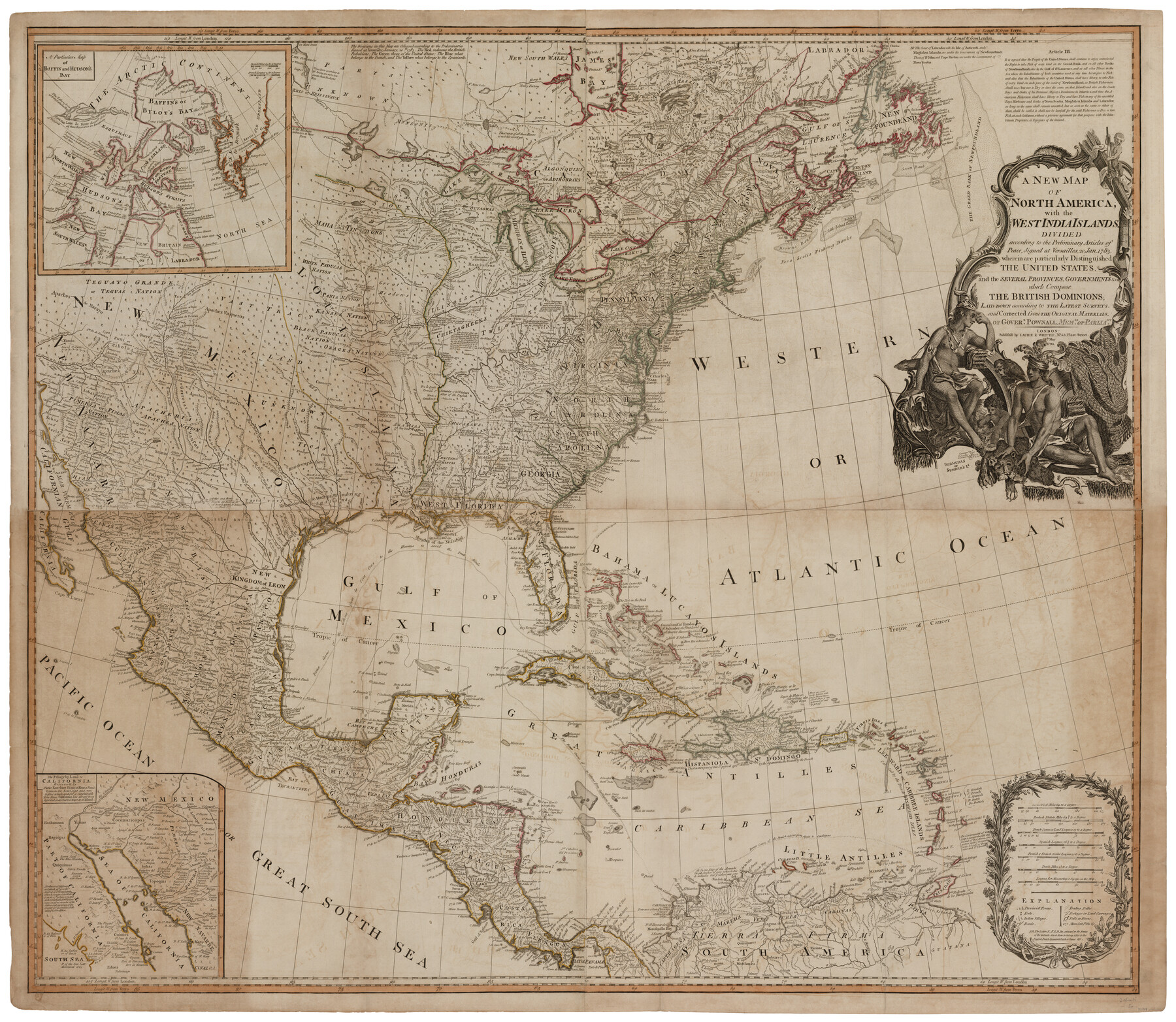
A New Map of North America with the West India Islands divided according to the preliminary Articles of Peace, signed at Versailles, 20 Jan. 1783
-
Map/Doc
93734
-
Collection
General Map Collection
-
Object Dates
1794/5/12 (Creation Date)
-
People and Organizations
Laurie & Whittle (Publisher)
Katherine Staat in memory of Herbert Christian Merillat (Donor)
-
Subjects
North America
-
Height x Width
42.1 x 48.4 inches
106.9 x 122.9 cm
-
Medium
paper
-
Comments
Map donated to the GLO by Katherine Staat in memory of Herbert Christian Merillat.
-
URLs
https://medium.com/save-texas-history/donated-maps-help-save-texas-history-illustrate-early-american-independence-9dcec5b25ea2#.hkqg1rghx
Part of: General Map Collection
Mexico & Guatimala with the Republic of Texas

Print $20.00
- Digital $50.00
Mexico & Guatimala with the Republic of Texas
1838
Size 19.3 x 22.6 inches
Map/Doc 94078
Flight Mission No. BQY-4M, Frame 62, Harris County

Print $20.00
- Digital $50.00
Flight Mission No. BQY-4M, Frame 62, Harris County
1953
Size 18.7 x 22.5 inches
Map/Doc 85271
Hudspeth County Rolled Sketch 64

Print $40.00
- Digital $50.00
Hudspeth County Rolled Sketch 64
1986
Size 39.1 x 81.9 inches
Map/Doc 9228
Kimble County Working Sketch 33

Print $20.00
- Digital $50.00
Kimble County Working Sketch 33
1945
Size 29.8 x 29.2 inches
Map/Doc 70101
Kenedy County Rolled Sketch 12

Print $20.00
- Digital $50.00
Kenedy County Rolled Sketch 12
1944
Size 34.6 x 41.1 inches
Map/Doc 9333
El Paso County Working Sketch 41

Print $20.00
- Digital $50.00
El Paso County Working Sketch 41
1985
Size 30.3 x 31.6 inches
Map/Doc 69063
Duval County Sketch File 73

Print $4.00
- Digital $50.00
Duval County Sketch File 73
Size 9.9 x 8.8 inches
Map/Doc 21463
Stonewall County Sketch File 8

Print $14.00
- Digital $50.00
Stonewall County Sketch File 8
1896
Size 8.7 x 7.7 inches
Map/Doc 37222
Dimmit County

Print $40.00
- Digital $50.00
Dimmit County
1976
Size 43.2 x 50.7 inches
Map/Doc 73133
Sabine Bank to East Bay including Heald Bank

Print $20.00
- Digital $50.00
Sabine Bank to East Bay including Heald Bank
1946
Size 44.8 x 33.9 inches
Map/Doc 69845
Navarro County Sketch File 10

Print $4.00
- Digital $50.00
Navarro County Sketch File 10
1860
Size 12.6 x 8.2 inches
Map/Doc 32318
Bexar County Working Sketch 21

Print $20.00
- Digital $50.00
Bexar County Working Sketch 21
1984
Size 21.3 x 28.8 inches
Map/Doc 67337
You may also like
Tom Green County Sketch File 72

Print $20.00
- Digital $50.00
Tom Green County Sketch File 72
1949
Size 24.3 x 28.5 inches
Map/Doc 12448
Yoakum County Sketch File 1

Print $10.00
- Digital $50.00
Yoakum County Sketch File 1
Size 9.4 x 8.3 inches
Map/Doc 40697
King County Sketch File 8

Print $46.00
- Digital $50.00
King County Sketch File 8
Size 8.8 x 8.9 inches
Map/Doc 29060
The State of Oklahoma

Print $20.00
- Digital $50.00
The State of Oklahoma
1916
Size 28.4 x 34.4 inches
Map/Doc 97104
Flight Mission No. BRA-8M, Frame 121, Jefferson County

Print $20.00
- Digital $50.00
Flight Mission No. BRA-8M, Frame 121, Jefferson County
1953
Size 18.5 x 22.4 inches
Map/Doc 85617
Flight Mission No. BRA-16M, Frame 123, Jefferson County

Print $20.00
- Digital $50.00
Flight Mission No. BRA-16M, Frame 123, Jefferson County
1953
Size 18.6 x 22.5 inches
Map/Doc 85733
Houston County Sketch File 6

Print $4.00
- Digital $50.00
Houston County Sketch File 6
1857
Size 12.0 x 4.7 inches
Map/Doc 26760
Maps of Gulf Intracoastal Waterway, Texas - Sabine River to the Rio Grande and connecting waterways including ship channels

Print $20.00
- Digital $50.00
Maps of Gulf Intracoastal Waterway, Texas - Sabine River to the Rio Grande and connecting waterways including ship channels
1966
Size 14.5 x 22.2 inches
Map/Doc 61973
Carte Générale du Royaume de la Nouvelle Espagne depuis le Parallele de 16° jusqu'au Parallele de 38° (Latitude Nord) dressée sur des Observations Astronomiques et sur l'ensemble des Matériaux qui existoient à Mexico, au commencement de l'année 1804

Print $20.00
- Digital $50.00
Carte Générale du Royaume de la Nouvelle Espagne depuis le Parallele de 16° jusqu'au Parallele de 38° (Latitude Nord) dressée sur des Observations Astronomiques et sur l'ensemble des Matériaux qui existoient à Mexico, au commencement de l'année 1804
1809
Size 21.7 x 32.9 inches
Map/Doc 93781
Map of Jones County West of the Clearfork of the Brazos River Young - East of it Milam - Land District

Print $20.00
- Digital $50.00
Map of Jones County West of the Clearfork of the Brazos River Young - East of it Milam - Land District
1859
Size 22.0 x 26.5 inches
Map/Doc 3741
Flight Mission No. CRC-3R, Frame 48, Chambers County

Print $20.00
- Digital $50.00
Flight Mission No. CRC-3R, Frame 48, Chambers County
1956
Size 18.7 x 22.4 inches
Map/Doc 84821
Parker County Sketch File C

Print $4.00
- Digital $50.00
Parker County Sketch File C
1857
Size 6.1 x 7.8 inches
Map/Doc 33512