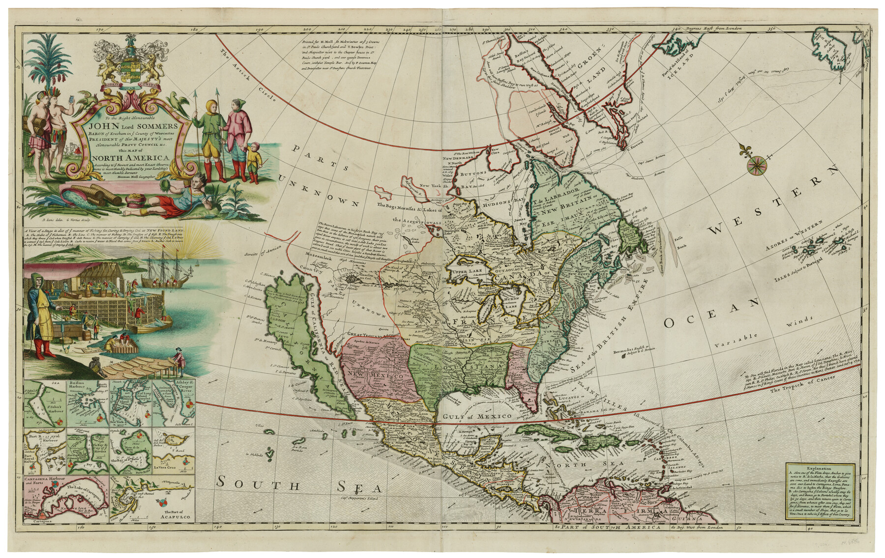
Map of North America
-
Map/Doc
93823
-
Collection
Holcomb Map Collection
-
Object Dates
1720 (Creation Date)
-
People and Organizations
D. Midwinter (Printer)
Herman Moll (Author)
-
Subjects
North America
-
Height x Width
25.0 x 39.6 inches
63.5 x 100.6 cm
-
Comments
Courtesy of Frank and Carol Holcomb.
Part of: Holcomb Map Collection
A Map of the United States including Louisiana

Print $20.00
- Digital $50.00
A Map of the United States including Louisiana
1817
Size 14.9 x 18.2 inches
Map/Doc 95964
Map of the United States of America, the British Provinces, Mexico, the West Indies and Central America with part of New Granada and Venezuela

Print $20.00
- Digital $50.00
Map of the United States of America, the British Provinces, Mexico, the West Indies and Central America with part of New Granada and Venezuela
1855
Size 34.7 x 44.0 inches
Map/Doc 93904
The Scarborough Company's New Railroad, Post Office & County Map of Texas, Oklahoma and Indian Territory Compiled from the Latest Government Surveys and Original Sources

Print $20.00
- Digital $50.00
The Scarborough Company's New Railroad, Post Office & County Map of Texas, Oklahoma and Indian Territory Compiled from the Latest Government Surveys and Original Sources
1904
Size 42.8 x 46.6 inches
Map/Doc 93911
Disturnell's New Map of the United States and Canada; showing all the canals, railroads, telegraph lines and principal stage routes

Print $20.00
- Digital $50.00
Disturnell's New Map of the United States and Canada; showing all the canals, railroads, telegraph lines and principal stage routes
1853
Size 28.1 x 40.9 inches
Map/Doc 93900
Map of Texas to accompany "Brady's Glimpses of Texas"

Print $20.00
- Digital $50.00
Map of Texas to accompany "Brady's Glimpses of Texas"
1871
Size 13.0 x 16.1 inches
Map/Doc 93907
Map of Texas shewing the grants in possession of the Colorado & Red River Land Compy

Print $20.00
- Digital $50.00
Map of Texas shewing the grants in possession of the Colorado & Red River Land Compy
1835
Size 20.3 x 26.9 inches
Map/Doc 93850
Smith's Atlas designed to accompany the Geography

Print $352.00
- Digital $50.00
Smith's Atlas designed to accompany the Geography
1850
Size 12.2 x 10.0 inches
Map/Doc 93881

North America

Print $20.00
- Digital $50.00
North America
1823
Size 21.9 x 25.6 inches
Map/Doc 93842
Carte d'Amerique, Divisee en ses Principaux Pays, Dressee sur les Memoires les plus recents, et sur differents Voyages, et assujettie aux observations Astronomiques de Mrs. de l'Academie Royale des Sciences

Print $40.00
- Digital $50.00
Carte d'Amerique, Divisee en ses Principaux Pays, Dressee sur les Memoires les plus recents, et sur differents Voyages, et assujettie aux observations Astronomiques de Mrs. de l'Academie Royale des Sciences
1787
Size 43.5 x 51.3 inches
Map/Doc 96430
Mapa de los Estados Unidos Mejicanos arreglado a la distribucion que en diversos decretos ha hecho del territorio el Congreso General Mejicano

Print $20.00
- Digital $50.00
Mapa de los Estados Unidos Mejicanos arreglado a la distribucion que en diversos decretos ha hecho del territorio el Congreso General Mejicano
1837
Size 24.3 x 29.4 inches
Map/Doc 96515
Map of North America

Print $20.00
- Digital $50.00
Map of North America
1720
Size 25.0 x 39.6 inches
Map/Doc 93823
You may also like
General Highway Map, Motley County, Texas

Print $20.00
General Highway Map, Motley County, Texas
1961
Size 24.7 x 18.1 inches
Map/Doc 79605
Brooks County Rolled Sketch 17

Print $20.00
- Digital $50.00
Brooks County Rolled Sketch 17
1941
Size 30.8 x 36.5 inches
Map/Doc 8532
No. 1 - Survey for a road from the Brazo Santiago to the Rio Grande

Print $20.00
- Digital $50.00
No. 1 - Survey for a road from the Brazo Santiago to the Rio Grande
1847
Size 18.3 x 27.2 inches
Map/Doc 72874
Pts. of G&M M-20, Y2 & H&TC 46

Print $2.00
- Digital $50.00
Pts. of G&M M-20, Y2 & H&TC 46
Size 6.6 x 15.2 inches
Map/Doc 91724
Flight Mission No. CUG-3P, Frame 132, Kleberg County

Print $20.00
- Digital $50.00
Flight Mission No. CUG-3P, Frame 132, Kleberg County
1956
Size 18.4 x 22.4 inches
Map/Doc 86267
Flight Mission No. CRC-3R, Frame 198, Chambers County

Print $20.00
- Digital $50.00
Flight Mission No. CRC-3R, Frame 198, Chambers County
1956
Size 18.5 x 22.2 inches
Map/Doc 84853
General Highway Map, Brewster County, Texas

Print $20.00
General Highway Map, Brewster County, Texas
1940
Size 18.5 x 25.1 inches
Map/Doc 79028
General Highway Map. Detail of Cities and Towns in Wharton County, Texas [El Campo and Wharton]
![79275, General Highway Map. Detail of Cities and Towns in Wharton County, Texas [El Campo and Wharton], Texas State Library and Archives](https://historictexasmaps.com/wmedia_w700/maps/79275.tif.jpg)
Print $20.00
General Highway Map. Detail of Cities and Towns in Wharton County, Texas [El Campo and Wharton]
1940
Size 18.4 x 24.8 inches
Map/Doc 79275
Flight Mission No. DAG-17K, Frame 122, Matagorda County

Print $20.00
- Digital $50.00
Flight Mission No. DAG-17K, Frame 122, Matagorda County
1952
Size 16.5 x 16.4 inches
Map/Doc 86342
The Judicial District/County of Madison. Created, February 2, 1842

Print $20.00
The Judicial District/County of Madison. Created, February 2, 1842
2020
Size 18.2 x 21.7 inches
Map/Doc 96333
New Birmingham, Cherokee County, Texas

Print $20.00
- Digital $50.00
New Birmingham, Cherokee County, Texas
1890
Size 31.0 x 36.2 inches
Map/Doc 451
Terrell County Sketch File 23

Print $10.00
- Digital $50.00
Terrell County Sketch File 23
1932
Size 14.3 x 8.9 inches
Map/Doc 37954