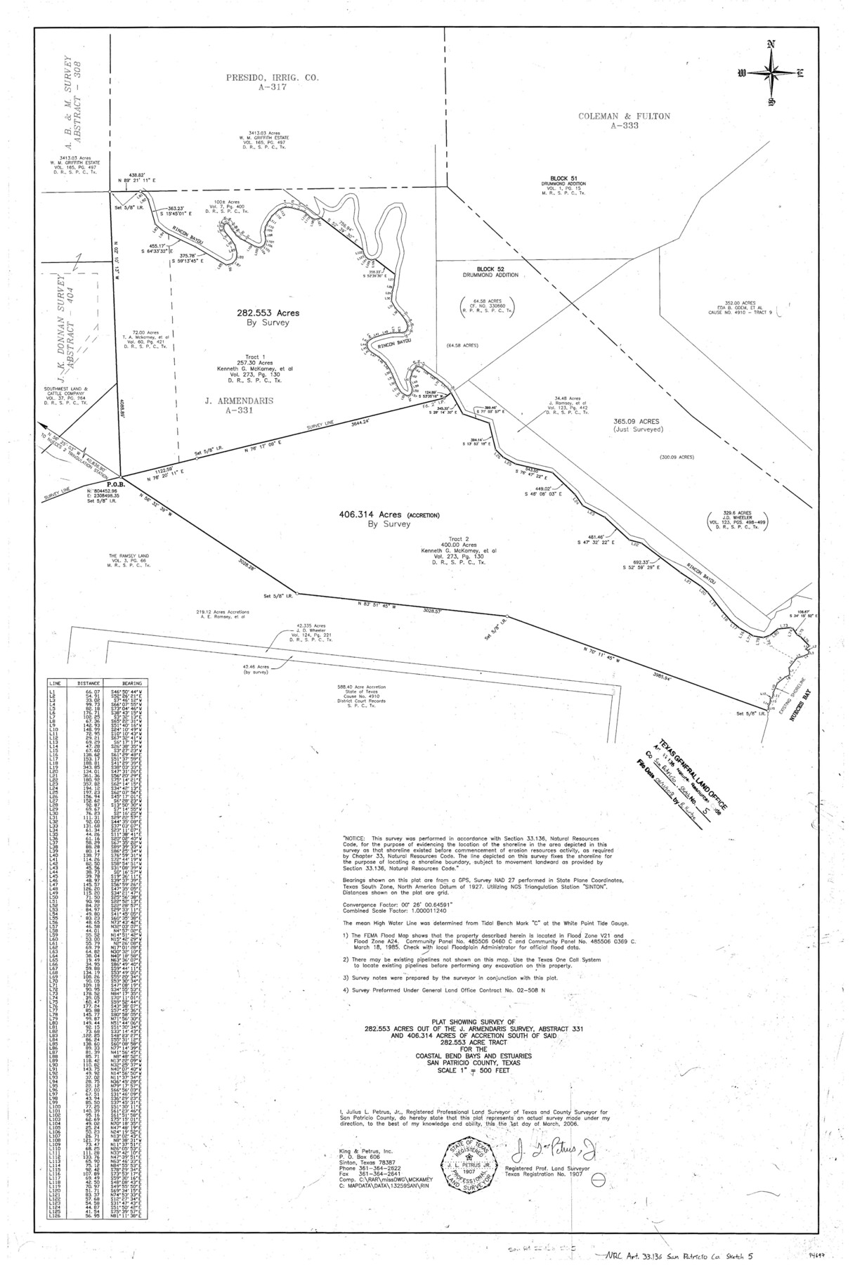
San Patricio County NRC Article 33.136 Sketch 5
Plat showing survey of 282.553 out of the J. Armendaris survey, abstract 331 and 406.314 acres of accretion south of said 282.553 acre tract for the Coastal Bend Bays and Estuaries
-
Map/Doc
94697
-
Collection
General Map Collection
-
Object Dates
2006/3/1 (Creation Date)
2018/6/21 (File Date)
-
People and Organizations
Julius L. Petrus, Jr. (Surveyor/Engineer)
-
Counties
San Patricio
-
Subjects
Surveying CBS
-
Height x Width
36.0 x 24.0 inches
91.4 x 61.0 cm
-
Medium
mylar, print
-
Scale
1" = 500 feet
Part of: General Map Collection
Harris County Rolled Sketch 88

Print $20.00
- Digital $50.00
Harris County Rolled Sketch 88
1937
Size 34.9 x 22.7 inches
Map/Doc 6126
Denison, Grayson County, Texas

Print $20.00
- Digital $50.00
Denison, Grayson County, Texas
1891
Size 23.7 x 35.7 inches
Map/Doc 97032
Shelby County Working Sketch 31a

Print $40.00
- Digital $50.00
Shelby County Working Sketch 31a
2003
Size 32.6 x 70.2 inches
Map/Doc 78643
Scurry County Working Sketch Graphic Index

Print $20.00
- Digital $50.00
Scurry County Working Sketch Graphic Index
1921
Size 39.9 x 37.0 inches
Map/Doc 76695
Wilson County Working Sketch 3

Print $20.00
- Digital $50.00
Wilson County Working Sketch 3
1952
Size 33.6 x 33.2 inches
Map/Doc 72583
Cooke County Working Sketch 1

Print $20.00
- Digital $50.00
Cooke County Working Sketch 1
Size 16.5 x 28.3 inches
Map/Doc 68238
Jeff Davis County Working Sketch 8

Print $20.00
- Digital $50.00
Jeff Davis County Working Sketch 8
1940
Size 45.4 x 42.9 inches
Map/Doc 66503
Glasscock County Sketch File 12

Print $5.00
- Digital $50.00
Glasscock County Sketch File 12
1935
Size 14.1 x 9.2 inches
Map/Doc 24176
Coast Chart No. 203 - Coast of Texas from Sabine Pass Westward to High Island

Print $20.00
- Digital $50.00
Coast Chart No. 203 - Coast of Texas from Sabine Pass Westward to High Island
1901
Size 40.4 x 34.3 inches
Map/Doc 69843
Bell County Working Sketch Graphic Index

Print $40.00
- Digital $50.00
Bell County Working Sketch Graphic Index
1945
Size 42.6 x 52.8 inches
Map/Doc 76465
Travis County Working Sketch 57

Print $20.00
- Digital $50.00
Travis County Working Sketch 57
1989
Size 42.8 x 44.0 inches
Map/Doc 69441
Bell County Sketch File 1

Print $40.00
- Digital $50.00
Bell County Sketch File 1
1847
Size 14.7 x 12.4 inches
Map/Doc 14365
You may also like
[Surveys in Southeast part of Stephens County]
![91909, [Surveys in Southeast part of Stephens County], Twichell Survey Records](https://historictexasmaps.com/wmedia_w700/maps/91909-1.tif.jpg)
Print $2.00
- Digital $50.00
[Surveys in Southeast part of Stephens County]
Size 9.1 x 7.0 inches
Map/Doc 91909
Flight Mission No. CRC-1R, Frame 38, Chambers County

Print $20.00
- Digital $50.00
Flight Mission No. CRC-1R, Frame 38, Chambers County
1956
Size 18.7 x 22.4 inches
Map/Doc 84706
Gaines County Working Sketch 28

Print $20.00
- Digital $50.00
Gaines County Working Sketch 28
1982
Size 20.9 x 24.6 inches
Map/Doc 69328
Dimmit County Sketch File 49

Print $20.00
- Digital $50.00
Dimmit County Sketch File 49
1909
Size 17.3 x 26.8 inches
Map/Doc 11358
[University Lands in West Texas]
![2422, [University Lands in West Texas], General Map Collection](https://historictexasmaps.com/wmedia_w700/maps/2422.tif.jpg)
Print $20.00
- Digital $50.00
[University Lands in West Texas]
1938
Size 20.3 x 28.1 inches
Map/Doc 2422

English Field Notes of the Spanish Archives - Book 4 & W

English Field Notes of the Spanish Archives - Book 4 & W
1836
Map/Doc 96530
Tarrant County Sketch File 10a

Print $6.00
- Digital $50.00
Tarrant County Sketch File 10a
1860
Size 10.3 x 8.1 inches
Map/Doc 37691
Falls County Sketch File 28

Print $2.00
- Digital $50.00
Falls County Sketch File 28
Size 7.7 x 10.3 inches
Map/Doc 22438
Scenes Around Carrizo Springs, Texas the Hub of the Winter Garden District

Print $20.00
- Digital $50.00
Scenes Around Carrizo Springs, Texas the Hub of the Winter Garden District
1920
Size 8.8 x 15.5 inches
Map/Doc 96767
Haskell County Rolled Sketch 5

Print $20.00
- Digital $50.00
Haskell County Rolled Sketch 5
1858
Size 30.0 x 39.0 inches
Map/Doc 6165
San Jacinto County Sketch File 3

Print $4.00
San Jacinto County Sketch File 3
1857
Size 10.3 x 8.1 inches
Map/Doc 35698