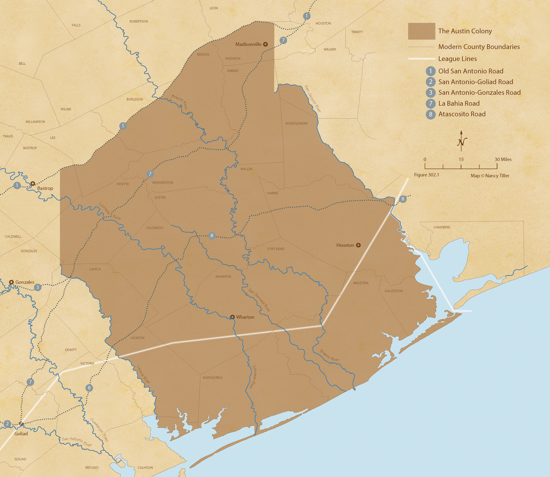
Austin Empresario Colony. January 17, 1821/February 18, 1823
Figure No. 302.1 from 'A Boundary Atlas of Texas, 1821-1845' by Jim Tiller
-
Map/Doc
95978
-
Collection
Nancy and Jim Tiller Digital Collection
-
Object Dates
1/1/2020 (Creation Date)
-
People and Organizations
Jim Tiller (Author)
Nancy Tiller (Cartographer)
Gang Gong (GIS Professional)
-
Subjects
Atlas Colony Mexican Texas Texas Boundaries
-
Height x Width
18.8 x 21.6 inches
47.8 x 54.9 cm
-
Medium
digital image
-
Comments
To purchase a digital PDF copy of "A Boundary Atlas of Texas, 1821-1845" see 96437.
Part of: Nancy and Jim Tiller Digital Collection
The Mexican Municipality of Matagorda. December 5, 1835

Print $20.00
The Mexican Municipality of Matagorda. December 5, 1835
2020
Size 15.9 x 21.7 inches
Map/Doc 96027
The Republic County of Colorado. January 19, 1841

Print $20.00
The Republic County of Colorado. January 19, 1841
2020
Size 18.4 x 21.7 inches
Map/Doc 96124
The Judicial District/County of DeWitt. Created, February 2, 1842

Print $20.00
The Judicial District/County of DeWitt. Created, February 2, 1842
2020
Size 22.4 x 21.7 inches
Map/Doc 96325
The Judicial District/County of Panola. Created, January 30, 1841

Print $20.00
The Judicial District/County of Panola. Created, January 30, 1841
2020
Size 19.3 x 21.6 inches
Map/Doc 96340
The Mexican Department of Nacogdoches. On the Eve of Texas Independence, 1836

Print $20.00
The Mexican Department of Nacogdoches. On the Eve of Texas Independence, 1836
2020
Size 18.4 x 21.7 inches
Map/Doc 95974
The Republic County of Fort Bend. January 10, 1839

Print $20.00
The Republic County of Fort Bend. January 10, 1839
2020
Size 14.7 x 21.6 inches
Map/Doc 96138
The Castro Colony. February 15, 1842

Print $20.00
The Castro Colony. February 15, 1842
2020
Size 23.0 x 17.7 inches
Map/Doc 96357
From Citizens Living Between the Brazos and Trinity Rivers and Below the Old San Antonio Road in Montgomery and Washington Counties for the Creation of a New County to be Called Travis, Undated

Print $20.00
From Citizens Living Between the Brazos and Trinity Rivers and Below the Old San Antonio Road in Montgomery and Washington Counties for the Creation of a New County to be Called Travis, Undated
2020
Size 21.2 x 21.7 inches
Map/Doc 96401
The Judicial District/County of Pashcal. Created, January 28, 1841

Print $20.00
The Judicial District/County of Pashcal. Created, January 28, 1841
2020
Size 15.0 x 21.7 inches
Map/Doc 96343
The Republic County of Shelby. January 16, 1843

Print $20.00
The Republic County of Shelby. January 16, 1843
2020
Size 20.0 x 21.7 inches
Map/Doc 96285
The Republic County of Fannin. December 29, 1845

Print $20.00
The Republic County of Fannin. December 29, 1845
2020
Size 12.9 x 21.7 inches
Map/Doc 96130

You may also like
McMullen County Rolled Sketch 13

Print $20.00
- Digital $50.00
McMullen County Rolled Sketch 13
1943
Size 45.8 x 29.4 inches
Map/Doc 6730
Flight Mission No. CLL-1N, Frame 192, Willacy County

Print $20.00
- Digital $50.00
Flight Mission No. CLL-1N, Frame 192, Willacy County
1954
Size 18.5 x 22.2 inches
Map/Doc 87062
[Index map of T. & P. Ry. Company’s 80-mile Trans-Pecos Reserve’s perpetuated corners - South Part]
![69766, [Index map of T. & P. Ry. Company’s 80-mile Trans-Pecos Reserve’s perpetuated corners - South Part], General Map Collection](https://historictexasmaps.com/wmedia_w700/maps/69766.tif.jpg)
Print $40.00
- Digital $50.00
[Index map of T. & P. Ry. Company’s 80-mile Trans-Pecos Reserve’s perpetuated corners - South Part]
Size 23.1 x 90.1 inches
Map/Doc 69766
Blanco County Working Sketch 10

Print $20.00
- Digital $50.00
Blanco County Working Sketch 10
1938
Size 28.3 x 25.8 inches
Map/Doc 67370
Bee County Sketch File 10

Print $4.00
- Digital $50.00
Bee County Sketch File 10
Size 12.8 x 7.9 inches
Map/Doc 14291
Ward County Working Sketch 37

Print $20.00
- Digital $50.00
Ward County Working Sketch 37
1969
Size 31.3 x 46.9 inches
Map/Doc 72343
Kaufman County Rolled Sketch 1

Print $20.00
- Digital $50.00
Kaufman County Rolled Sketch 1
1951
Size 26.4 x 34.8 inches
Map/Doc 6456
Crockett County Working Sketch 71

Print $20.00
- Digital $50.00
Crockett County Working Sketch 71
1963
Size 38.7 x 32.7 inches
Map/Doc 68404
Travis County Boundary File 24

Print $4.00
- Digital $50.00
Travis County Boundary File 24
Size 8.3 x 7.2 inches
Map/Doc 59457
[H. & T. C. Block 34 and PSL Block B-19]
![91948, [H. & T. C. Block 34 and PSL Block B-19], Twichell Survey Records](https://historictexasmaps.com/wmedia_w700/maps/91948-1.tif.jpg)
Print $20.00
- Digital $50.00
[H. & T. C. Block 34 and PSL Block B-19]
Size 30.6 x 30.6 inches
Map/Doc 91948
Travis County Working Sketch 39

Print $20.00
- Digital $50.00
Travis County Working Sketch 39
1974
Size 33.1 x 31.7 inches
Map/Doc 69423
Cooke County Rolled Sketch 6

Print $20.00
- Digital $50.00
Cooke County Rolled Sketch 6
1981
Size 19.7 x 25.1 inches
Map/Doc 5564