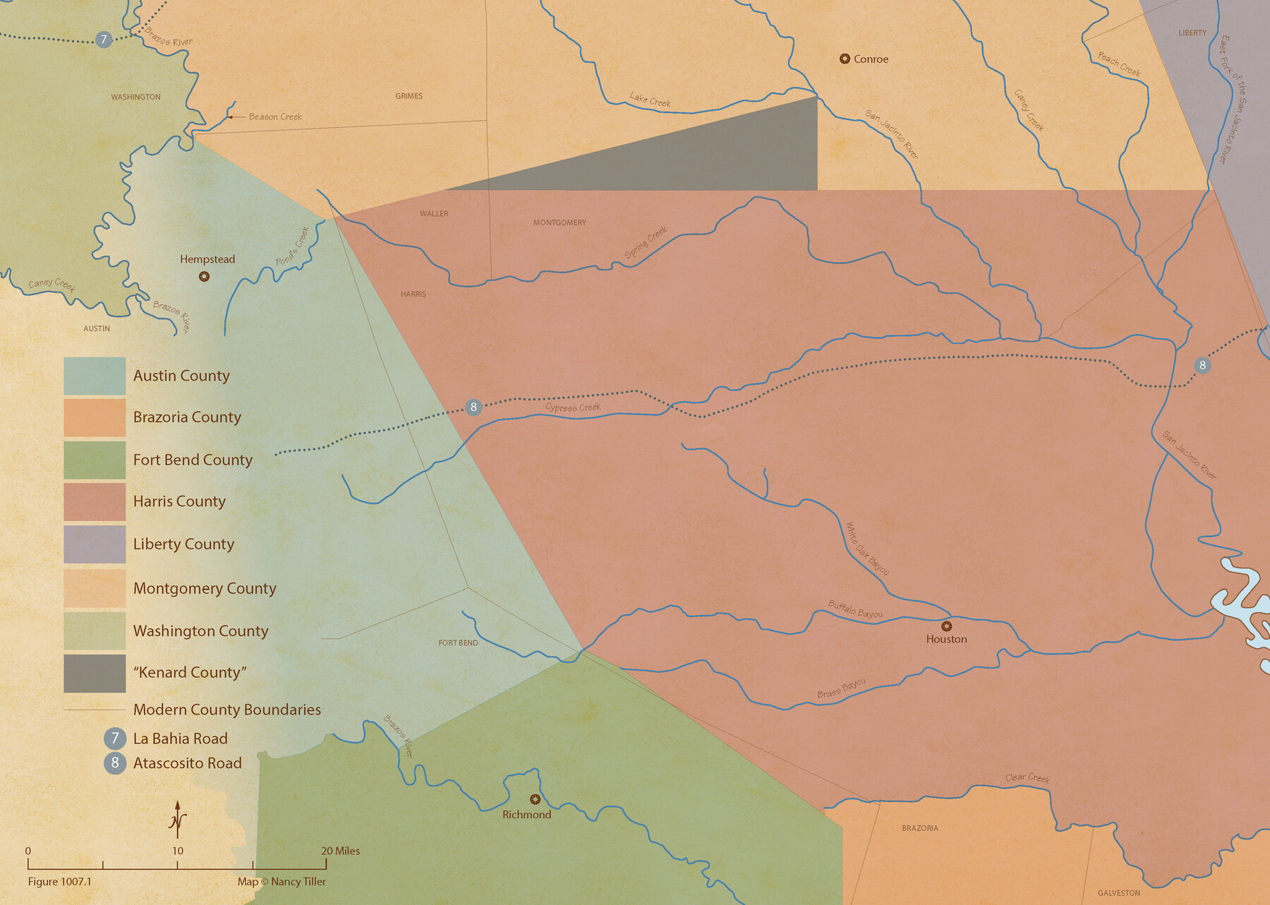
Letter from Jesse Grimes Noting the Existence of “Kenard County” Between Harris and Montgomery Counties, April 30, 1838
Figure No. 1007.1 from 'A Boundary Atlas of Texas, 1821-1845' by Jim Tiller
-
Map/Doc
96380
-
Collection
Nancy and Jim Tiller Digital Collection
-
Object Dates
2020/1/1 (Creation Date)
-
People and Organizations
Jim Tiller (Author)
Nancy Tiller (Cartographer)
Gang Gong (GIS Professional)
-
Subjects
Atlas Republic of Texas Texas Boundaries
-
Height x Width
15.4 x 21.7 inches
39.1 x 55.1 cm
-
Medium
digital image
-
Comments
To purchase a digital PDF copy of "A Boundary Atlas of Texas, 1821-1845" see 96437.
Part of: Nancy and Jim Tiller Digital Collection
The Republic County of Fannin. December 29, 1845

Print $20.00
The Republic County of Fannin. December 29, 1845
2020
Size 12.9 x 21.7 inches
Map/Doc 96130
The Republic County of Victoria. January 29, 1842

Print $20.00
The Republic County of Victoria. January 29, 1842
2020
Size 24.3 x 21.7 inches
Map/Doc 96298
Vehlein and Company Empresario Colony. November 17, 1828

Print $20.00
Vehlein and Company Empresario Colony. November 17, 1828
2020
Size 20.8 x 21.7 inches
Map/Doc 96008
The Republic County of Houston. February 2, 1842

Print $20.00
The Republic County of Houston. February 2, 1842
2020
Size 19.7 x 21.8 inches
Map/Doc 96181
The Mexican Municipalities. On the Eve of Texas Independence, 1836

Print $20.00
The Mexican Municipalities. On the Eve of Texas Independence, 1836
2020
Size 17.2 x 21.6 inches
Map/Doc 96013
The Fisher-Miller Colony. September 1, 1843

Print $20.00
The Fisher-Miller Colony. September 1, 1843
2020
Size 13.8 x 21.7 inches
Map/Doc 96359
The Republic County of Victoria. Spring 1842

Print $20.00
The Republic County of Victoria. Spring 1842
2020
Size 24.3 x 21.7 inches
Map/Doc 96300
Dominguez Empresario Colony. February 6, 1829

Print $20.00
Dominguez Empresario Colony. February 6, 1829
2020
Size 17.2 x 21.7 inches
Map/Doc 95992

The Republic County of San Patricio. December 29, 1845

Print $20.00
The Republic County of San Patricio. December 29, 1845
2020
Size 22.2 x 21.7 inches
Map/Doc 96278
The Land Offices. No. 3, Liberty, December 22, 1836

Print $20.00
The Land Offices. No. 3, Liberty, December 22, 1836
2020
Size 16.0 x 21.7 inches
Map/Doc 96416
The Republic County of Washington. Boundaries Defined, December 14, 1837

Print $20.00
The Republic County of Washington. Boundaries Defined, December 14, 1837
2020
Size 20.3 x 21.7 inches
Map/Doc 96302
You may also like
Flight Mission No. DQO-2K, Frame 160, Galveston County

Print $20.00
- Digital $50.00
Flight Mission No. DQO-2K, Frame 160, Galveston County
1952
Size 18.7 x 22.4 inches
Map/Doc 85049
San Augustine County Sketch File 19

Print $23.00
San Augustine County Sketch File 19
Size 14.8 x 14.2 inches
Map/Doc 35678
Lavaca County Working Sketch 26

Print $20.00
- Digital $50.00
Lavaca County Working Sketch 26
1986
Size 25.0 x 28.1 inches
Map/Doc 70379
Pecos County Rolled Sketch 82

Print $20.00
- Digital $50.00
Pecos County Rolled Sketch 82
1930
Size 28.4 x 25.7 inches
Map/Doc 10190
Sketch for Mineral Application 33721 - 33725 Incl (Attorney General) - Map of Padre Island - Cameron, Willacy, Kleberg, Nueces and Kenedy Counties.

Print $20.00
- Digital $50.00
Sketch for Mineral Application 33721 - 33725 Incl (Attorney General) - Map of Padre Island - Cameron, Willacy, Kleberg, Nueces and Kenedy Counties.
Size 43.3 x 23.1 inches
Map/Doc 65663
Hutchinson County Rolled Sketch 40

Print $20.00
- Digital $50.00
Hutchinson County Rolled Sketch 40
1981
Size 26.2 x 37.4 inches
Map/Doc 6305
Colorado River, Lane City Sheet

Print $4.00
- Digital $50.00
Colorado River, Lane City Sheet
1941
Size 27.0 x 29.9 inches
Map/Doc 65316
Shackelford County Rolled Sketch 3

Print $40.00
- Digital $50.00
Shackelford County Rolled Sketch 3
1955
Size 35.4 x 49.9 inches
Map/Doc 9915
Atascosa County Working Sketch 29

Print $20.00
- Digital $50.00
Atascosa County Working Sketch 29
1977
Size 16.8 x 15.1 inches
Map/Doc 67225
Shelby County Working Sketch 11

Print $20.00
- Digital $50.00
Shelby County Working Sketch 11
1945
Size 32.2 x 43.2 inches
Map/Doc 63864
[Maps of surveys in Reeves & Culberson Cos]
![61142, [Maps of surveys in Reeves & Culberson Cos], General Map Collection](https://historictexasmaps.com/wmedia_w700/maps/61142.tif.jpg)
Print $20.00
- Digital $50.00
[Maps of surveys in Reeves & Culberson Cos]
1937
Size 30.6 x 24.8 inches
Map/Doc 61142
Guadalupe County Sketch File 21

Print $6.00
- Digital $50.00
Guadalupe County Sketch File 21
Size 9.9 x 8.5 inches
Map/Doc 24702