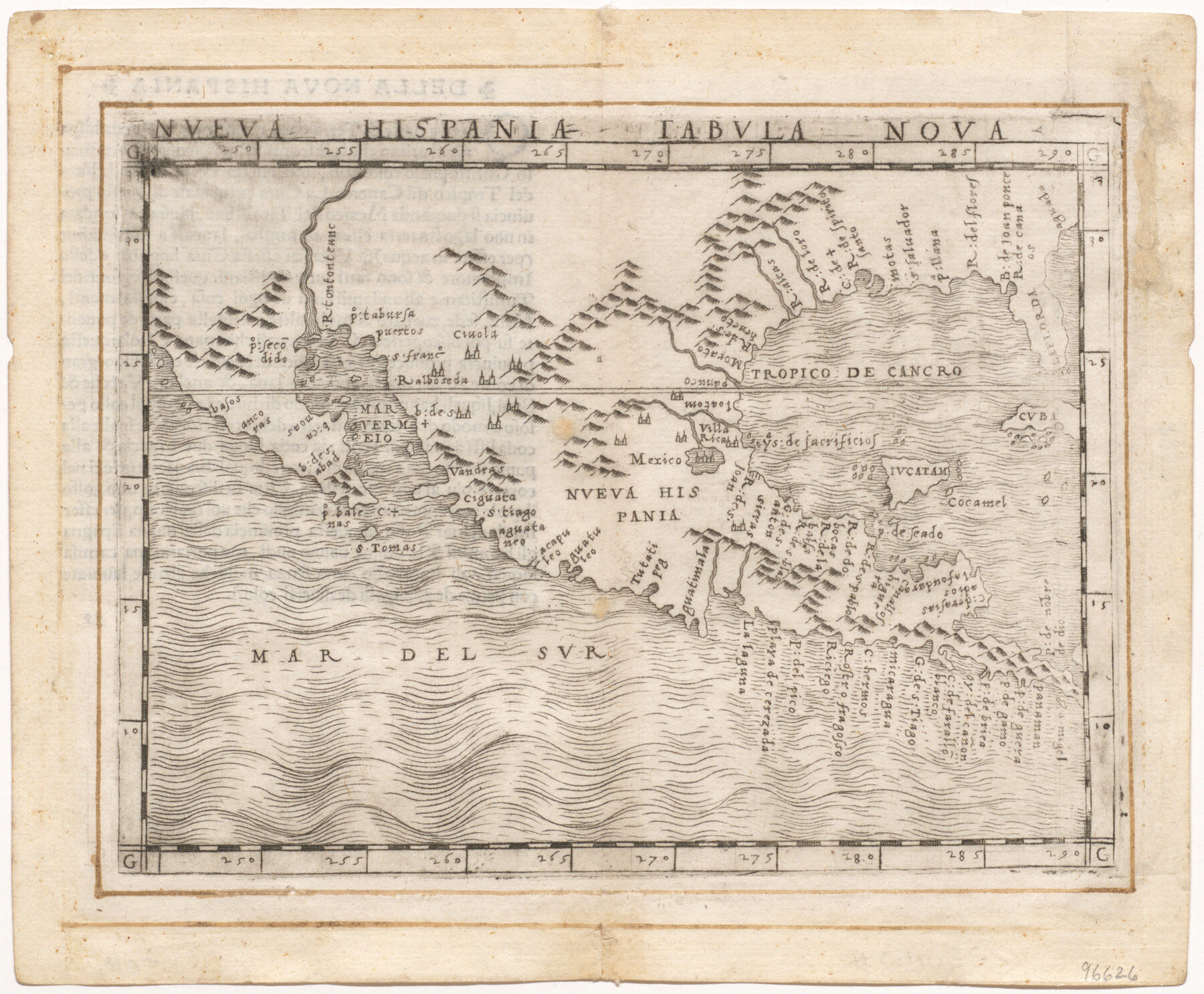
Nueva Hispania Tabula Nova
-
Map/Doc
96626
-
Collection
General Map Collection
-
Object Dates
[1548] (Creation Date)
-
People and Organizations
Giacomo Gastaldi (Cartographer)
-
Subjects
Spanish Texas
-
Height x Width
6.8 x 8.2 inches
17.3 x 20.8 cm
-
Medium
paper, etching/engraving/lithograph
-
Comments
To view text on verso, click the "Download PDF" link above.
Part of: General Map Collection
Fannin County Sketch File 8

Print $4.00
- Digital $50.00
Fannin County Sketch File 8
Size 8.7 x 13.3 inches
Map/Doc 22453
McMullen County Working Sketch 29

Print $40.00
- Digital $50.00
McMullen County Working Sketch 29
1956
Size 59.0 x 37.2 inches
Map/Doc 70730
Flight Mission No. DQN-2K, Frame 190, Calhoun County

Print $20.00
- Digital $50.00
Flight Mission No. DQN-2K, Frame 190, Calhoun County
1953
Size 18.5 x 22.2 inches
Map/Doc 84331

Goliad County Sketch File 27

Print $20.00
- Digital $50.00
Goliad County Sketch File 27
Size 19.0 x 24.4 inches
Map/Doc 11568
Wilbarger County Working Sketch Graphic Index

Print $20.00
- Digital $50.00
Wilbarger County Working Sketch Graphic Index
1949
Size 46.7 x 38.0 inches
Map/Doc 76740
Lamar County Sketch File 2

Print $4.00
- Digital $50.00
Lamar County Sketch File 2
1859
Size 12.1 x 7.5 inches
Map/Doc 29273
McMullen County Sketch File 5

Print $4.00
- Digital $50.00
McMullen County Sketch File 5
1854
Size 8.7 x 8.3 inches
Map/Doc 31343
San Patricio County Sketch File 13

Print $4.00
San Patricio County Sketch File 13
Size 5.9 x 8.5 inches
Map/Doc 36049
Moore County Working Sketch Graphic Index

Print $20.00
- Digital $50.00
Moore County Working Sketch Graphic Index
1932
Size 41.3 x 39.0 inches
Map/Doc 76648
[Surveys in Austin's Colony along Buffalo Bayou and the San Jacinto River]
![51, [Surveys in Austin's Colony along Buffalo Bayou and the San Jacinto River], General Map Collection](https://historictexasmaps.com/wmedia_w700/maps/51.tif.jpg)
Print $20.00
- Digital $50.00
[Surveys in Austin's Colony along Buffalo Bayou and the San Jacinto River]
1824
Size 23.7 x 17.6 inches
Map/Doc 51
Flight Mission No. DQN-1K, Frame 141, Calhoun County

Print $20.00
- Digital $50.00
Flight Mission No. DQN-1K, Frame 141, Calhoun County
1953
Size 18.5 x 22.1 inches
Map/Doc 84204
You may also like
Crosby County Sketch File 21

Print $6.00
- Digital $50.00
Crosby County Sketch File 21
Size 13.8 x 8.8 inches
Map/Doc 20087

[Blocks B16, B7, B15]
![93130, [Blocks B16, B7, B15], Twichell Survey Records](https://historictexasmaps.com/wmedia_w700/maps/93130-1.tif.jpg)
Print $40.00
- Digital $50.00
[Blocks B16, B7, B15]
Size 57.2 x 51.5 inches
Map/Doc 93130
Burnet County Working Sketch 3

Print $20.00
- Digital $50.00
Burnet County Working Sketch 3
1953
Size 31.4 x 26.9 inches
Map/Doc 67846
Flight Mission No. CUG-1P, Frame 23, Kleberg County

Print $20.00
- Digital $50.00
Flight Mission No. CUG-1P, Frame 23, Kleberg County
1956
Size 18.5 x 22.1 inches
Map/Doc 86113
Harris County Working Sketch 66

Print $40.00
- Digital $50.00
Harris County Working Sketch 66
1955
Size 33.7 x 49.7 inches
Map/Doc 65958
Ellwood Farms, Situated in Lamb County, Texas

Print $20.00
- Digital $50.00
Ellwood Farms, Situated in Lamb County, Texas
Size 12.5 x 22.8 inches
Map/Doc 90993
Austin County

Print $20.00
- Digital $50.00
Austin County
1943
Size 38.5 x 41.3 inches
Map/Doc 77205
Flight Mission No. DQO-7K, Frame 99, Galveston County

Print $20.00
- Digital $50.00
Flight Mission No. DQO-7K, Frame 99, Galveston County
1952
Size 18.7 x 22.5 inches
Map/Doc 85114
General Highway Map, Edwards County, Real County, Texas

Print $20.00
General Highway Map, Edwards County, Real County, Texas
1961
Size 18.1 x 24.7 inches
Map/Doc 79452
Liberty County Sketch File 52

Print $20.00
- Digital $50.00
Liberty County Sketch File 52
Size 17.5 x 13.5 inches
Map/Doc 11995
[Map of Block 97, Borden and Scurry Co (Exhibit A); Map of Southeastern part of Young Territory; Map of part of of Borden, Fisher, Kent, Mitchell, Scurry and Garza Cos. Showing the north boundary line of the T&P 80 mile reservation]
![65692, [Map of Block 97, Borden and Scurry Co (Exhibit A); Map of Southeastern part of Young Territory; Map of part of of Borden, Fisher, Kent, Mitchell, Scurry and Garza Cos. Showing the north boundary line of the T&P 80 mile reservation], General Map Collection](https://historictexasmaps.com/wmedia_w700/maps/65692-1.tif.jpg)
Print $20.00
- Digital $50.00
[Map of Block 97, Borden and Scurry Co (Exhibit A); Map of Southeastern part of Young Territory; Map of part of of Borden, Fisher, Kent, Mitchell, Scurry and Garza Cos. Showing the north boundary line of the T&P 80 mile reservation]
1873
Size 33.4 x 29.6 inches
Map/Doc 65692