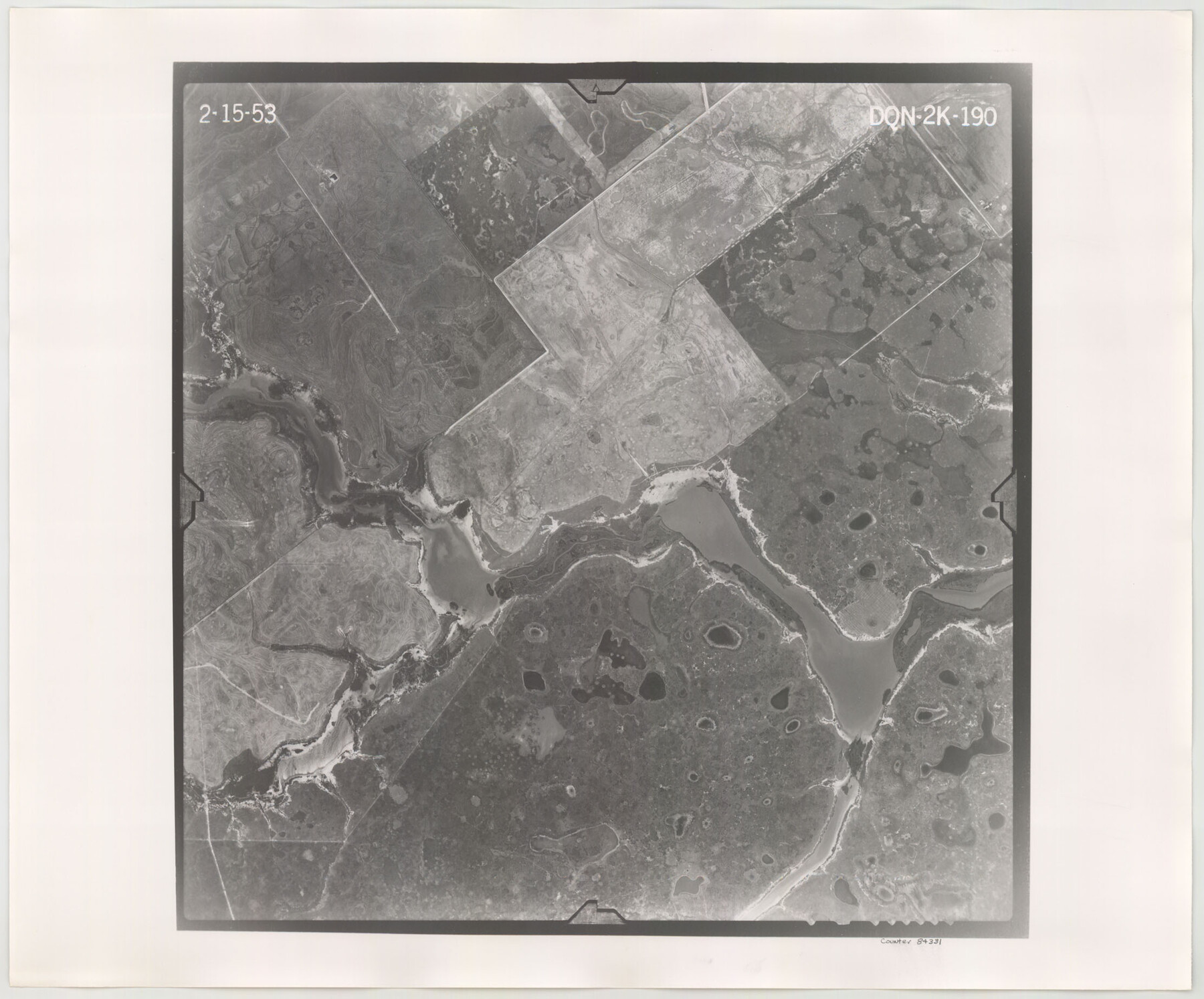
Flight Mission No. DQN-2K, Frame 190, Calhoun County
DQN-2K-190
-
Map/Doc
84331
-
Collection
General Map Collection
-
Object Dates
1953/2/15 (Creation Date)
-
People and Organizations
U. S. Department of Agriculture (Publisher)
-
Counties
Calhoun
-
Subjects
Aerial Photograph
-
Height x Width
18.5 x 22.2 inches
47.0 x 56.4 cm
-
Comments
Flown by Aero Exploration Company of Tulsa, Oklahoma.
Part of: General Map Collection
Brazoria County Rolled Sketch 50A

Print $20.00
- Digital $50.00
Brazoria County Rolled Sketch 50A
1932
Size 17.8 x 26.1 inches
Map/Doc 5188
Harris County Working Sketch 29

Print $20.00
- Digital $50.00
Harris County Working Sketch 29
1934
Size 22.6 x 30.5 inches
Map/Doc 65921
Flight Mission No. DCL-7C, Frame 20, Kenedy County

Print $20.00
- Digital $50.00
Flight Mission No. DCL-7C, Frame 20, Kenedy County
1943
Size 15.5 x 15.1 inches
Map/Doc 86012
Morris County Boundary File 1

Print $18.00
- Digital $50.00
Morris County Boundary File 1
Size 14.1 x 8.7 inches
Map/Doc 57473
Presidio County Rolled Sketch 99

Print $20.00
- Digital $50.00
Presidio County Rolled Sketch 99
Size 38.7 x 33.6 inches
Map/Doc 9784
Galveston County NRC Article 33.136 Sketch 99

Print $26.00
Galveston County NRC Article 33.136 Sketch 99
2024
Map/Doc 97422

Tom Green County Working Sketch 11

Print $20.00
- Digital $50.00
Tom Green County Working Sketch 11
1968
Size 33.9 x 39.2 inches
Map/Doc 69380
Maps of Gulf Intracoastal Waterway, Texas - Sabine River to the Rio Grande and connecting waterways including ship channels

Print $20.00
- Digital $50.00
Maps of Gulf Intracoastal Waterway, Texas - Sabine River to the Rio Grande and connecting waterways including ship channels
1966
Size 14.6 x 22.2 inches
Map/Doc 61979
Terrell County Sketch File 15

Print $20.00
- Digital $50.00
Terrell County Sketch File 15
1890
Size 16.0 x 21.6 inches
Map/Doc 12421
Jones County Sketch File 14

Print $4.00
- Digital $50.00
Jones County Sketch File 14
1882
Size 11.7 x 8.8 inches
Map/Doc 28501
Flight Mission No. BRE-1P, Frame 31, Nueces County

Print $20.00
- Digital $50.00
Flight Mission No. BRE-1P, Frame 31, Nueces County
1956
Size 18.0 x 21.6 inches
Map/Doc 86627
You may also like
Lines of Equal Magnetic Declination and of Equal Annual Change in the United States for 1930

Print $20.00
- Digital $50.00
Lines of Equal Magnetic Declination and of Equal Annual Change in the United States for 1930
1930
Size 23.5 x 29.7 inches
Map/Doc 69652
Baylor County Sketch File 20

Print $8.00
- Digital $50.00
Baylor County Sketch File 20
1887
Size 12.9 x 8.2 inches
Map/Doc 14195
Trinity River, Bazzette Sheet

Print $20.00
- Digital $50.00
Trinity River, Bazzette Sheet
1925
Size 27.9 x 23.8 inches
Map/Doc 78339
Houston County

Print $20.00
- Digital $50.00
Houston County
1868
Size 25.5 x 26.1 inches
Map/Doc 3685
Kendall County Working Sketch 5

Print $20.00
- Digital $50.00
Kendall County Working Sketch 5
1946
Size 30.4 x 28.6 inches
Map/Doc 66677
Map of Blanco County

Print $20.00
- Digital $50.00
Map of Blanco County
1862
Size 28.1 x 18.7 inches
Map/Doc 3303
[Wilson Strickland Survey and Vicinity, Exhibit L]
![91377, [Wilson Strickland Survey and Vicinity, Exhibit L], Twichell Survey Records](https://historictexasmaps.com/wmedia_w700/maps/91377-1.tif.jpg)
Print $20.00
- Digital $50.00
[Wilson Strickland Survey and Vicinity, Exhibit L]
Size 32.8 x 27.1 inches
Map/Doc 91377
Harris County Rolled Sketch R & B

Print $40.00
- Digital $50.00
Harris County Rolled Sketch R & B
1901
Size 27.9 x 60.6 inches
Map/Doc 8344
Located Line of the Panhandle & Gulf Ry. through State Lands, Public School and University, in Reagan County, Texas, Right of Way 200 feet wide

Print $40.00
- Digital $50.00
Located Line of the Panhandle & Gulf Ry. through State Lands, Public School and University, in Reagan County, Texas, Right of Way 200 feet wide
1904
Size 13.4 x 90.8 inches
Map/Doc 64063
Map of the United States and Territories to accompany annual report of Hon. N.C. McFarland, Commissioner, General Land Office for fiscal year which ended June 30, 1884

Print $20.00
- Digital $50.00
Map of the United States and Territories to accompany annual report of Hon. N.C. McFarland, Commissioner, General Land Office for fiscal year which ended June 30, 1884
1884
Size 27.0 x 39.3 inches
Map/Doc 96631
Map of Denton County

Print $20.00
- Digital $50.00
Map of Denton County
1877
Size 20.7 x 18.6 inches
Map/Doc 3475
[Sketch of Sections 61-64, l. & G. N. Block 1]
![91620, [Sketch of Sections 61-64, l. & G. N. Block 1], Twichell Survey Records](https://historictexasmaps.com/wmedia_w700/maps/91620-1.tif.jpg)
Print $20.00
- Digital $50.00
[Sketch of Sections 61-64, l. & G. N. Block 1]
Size 39.5 x 22.7 inches
Map/Doc 91620