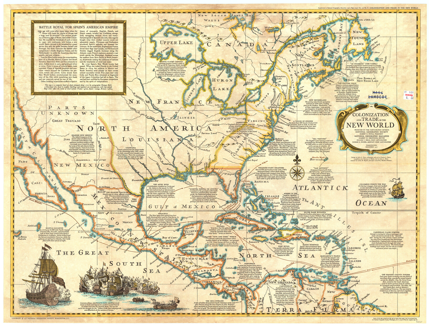
Colonization and Trade in the New World
-
Map/Doc
96835
-
Collection
General Map Collection
-
Object Dates
12/1977 (Creation Date)
-
People and Organizations
Cartographic Division, National Geographic Society (Publisher)
Mark Lambert (Donor)
-
Subjects
Central America North America
-
Height x Width
23.1 x 30.3 inches
58.7 x 77.0 cm
-
Medium
paper, print
-
Comments
For research only. Donated by Mark Lambert in May, 2022. See 96836 for verso.
Related maps
History Salvaged from the Sea

History Salvaged from the Sea
1977
Size 23.0 x 30.4 inches
Map/Doc 96836
Part of: General Map Collection
[Blanco County]
![3307, [Blanco County], General Map Collection](https://historictexasmaps.com/wmedia_w700/maps/3307-2.tif.jpg)
Print $20.00
- Digital $50.00
[Blanco County]
1872
Size 19.1 x 16.0 inches
Map/Doc 3307
Harris County NRC Article 33.136 Sketch 1

Print $26.00
- Digital $50.00
Harris County NRC Article 33.136 Sketch 1
2000
Size 24.3 x 36.3 inches
Map/Doc 61595
Old Miscellaneous File 10

Print $4.00
- Digital $50.00
Old Miscellaneous File 10
Size 9.6 x 8.2 inches
Map/Doc 75435
McMullen County Working Sketch 4

Print $20.00
- Digital $50.00
McMullen County Working Sketch 4
1922
Size 36.2 x 36.6 inches
Map/Doc 70705
Travis County State Real Property Sketch 13

Print $26.00
- Digital $50.00
Travis County State Real Property Sketch 13
2006
Size 35.3 x 24.1 inches
Map/Doc 88620
Palo Pinto County Sketch File 6a

Print $20.00
- Digital $50.00
Palo Pinto County Sketch File 6a
Size 37.8 x 38.6 inches
Map/Doc 10565


Cooke County Boundary File 19

Print $30.00
- Digital $50.00
Cooke County Boundary File 19
Size 8.7 x 4.0 inches
Map/Doc 51858
Map of section no. 10 of a survey of Padre Island made for the Office of the Attorney General of the State of Texas

Print $40.00
- Digital $50.00
Map of section no. 10 of a survey of Padre Island made for the Office of the Attorney General of the State of Texas
1941
Size 57.2 x 40.6 inches
Map/Doc 2266
Travis County Working Sketch 64

Print $20.00
- Digital $50.00
Travis County Working Sketch 64
2000
Size 16.8 x 19.6 inches
Map/Doc 69448
Edwards County Working Sketch 94

Print $40.00
- Digital $50.00
Edwards County Working Sketch 94
1968
Size 28.0 x 49.4 inches
Map/Doc 68970
You may also like
San Jacinto County Sketch File 9

Print $4.00
San Jacinto County Sketch File 9
1860
Size 8.7 x 11.7 inches
Map/Doc 35712
Jones County Working Sketch Graphic Index

Print $20.00
- Digital $50.00
Jones County Working Sketch Graphic Index
1921
Size 39.5 x 38.6 inches
Map/Doc 76599
General Highway Map, Smith County, Texas

Print $20.00
General Highway Map, Smith County, Texas
1961
Size 25.1 x 18.3 inches
Map/Doc 79654
Sabine County Sketch File 4

Print $22.00
Sabine County Sketch File 4
1876
Size 8.1 x 12.8 inches
Map/Doc 35606
Bosque County

Print $20.00
- Digital $50.00
Bosque County
1945
Size 42.6 x 33.0 inches
Map/Doc 77215
Baylor County Sketch File 9

Print $50.00
- Digital $50.00
Baylor County Sketch File 9
1890
Size 13.4 x 9.0 inches
Map/Doc 14139
Acts of the Visit of the Royal Commissioners (sometimes referred to as the “Visita General”) - Laredo

Acts of the Visit of the Royal Commissioners (sometimes referred to as the “Visita General”) - Laredo
1797
Size 14.1 x 9.3 inches
Map/Doc 94256
This is a sketch of Austin town tract

Print $2.00
- Digital $50.00
This is a sketch of Austin town tract
Size 6.5 x 8.1 inches
Map/Doc 148
Stonewall County Sketch File 13

Print $20.00
- Digital $50.00
Stonewall County Sketch File 13
1901
Size 22.4 x 18.8 inches
Map/Doc 12365
Starr County Rolled Sketch 20

Print $20.00
- Digital $50.00
Starr County Rolled Sketch 20
1921
Size 23.6 x 15.4 inches
Map/Doc 7804
Bailey County Sketch File 15

Print $18.00
- Digital $50.00
Bailey County Sketch File 15
1912
Size 8.7 x 11.2 inches
Map/Doc 13975
Flight Mission No. DIX-6P, Frame 196, Aransas County

Print $20.00
- Digital $50.00
Flight Mission No. DIX-6P, Frame 196, Aransas County
1956
Size 18.9 x 22.6 inches
Map/Doc 83858