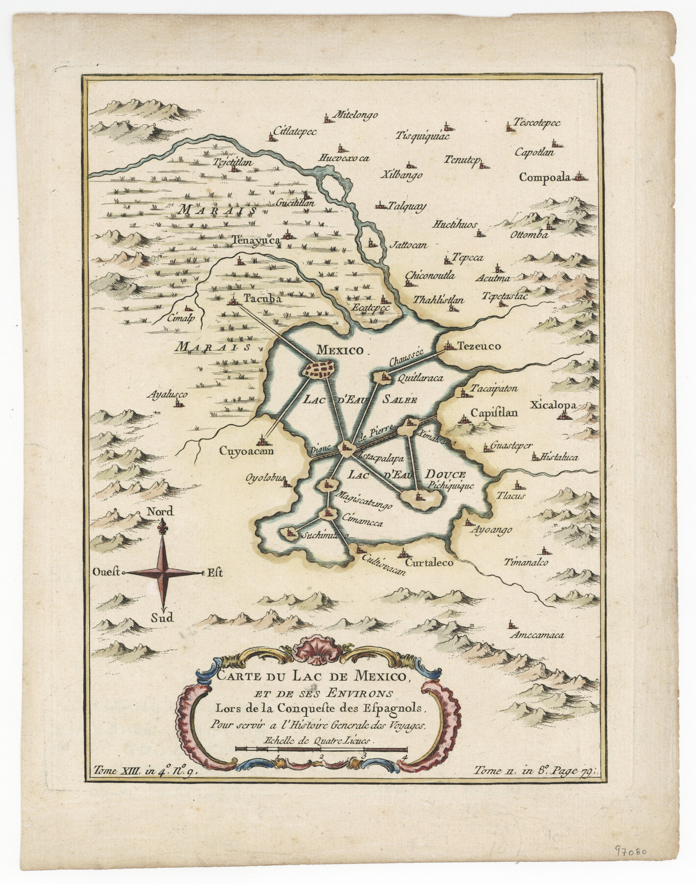
Carte du Lac de Mexico et de ses Environs Lors de la Conqueste des Espagnols
-
Map/Doc
97080
-
Collection
General Map Collection
-
Object Dates
[1753] (Creation Date)
-
People and Organizations
Jacques Nicolas Bellin (Cartographer)
-
Subjects
Mexico
-
Height x Width
10.3 x 8.1 inches
26.2 x 20.6 cm
-
Medium
paper, etching/engraving/lithograph
Part of: General Map Collection
Lipscomb County Boundary File 10

Print $18.00
- Digital $50.00
Lipscomb County Boundary File 10
Size 11.2 x 8.6 inches
Map/Doc 56338
Brewster County Working Sketch 58

Print $20.00
- Digital $50.00
Brewster County Working Sketch 58
1955
Size 19.8 x 21.7 inches
Map/Doc 67659
Ochiltree County Sketch File 7

Print $20.00
- Digital $50.00
Ochiltree County Sketch File 7
Size 14.5 x 26.1 inches
Map/Doc 42204
Comanche County Working Sketch 3

Print $20.00
- Digital $50.00
Comanche County Working Sketch 3
1919
Size 21.9 x 12.6 inches
Map/Doc 68137
Foard County Sketch File 2

Print $40.00
- Digital $50.00
Foard County Sketch File 2
Size 23.8 x 16.3 inches
Map/Doc 11490
Wichita County Sketch File 22

Print $10.00
- Digital $50.00
Wichita County Sketch File 22
1911
Size 11.3 x 8.6 inches
Map/Doc 40104
Kerr County Working Sketch 32

Print $20.00
- Digital $50.00
Kerr County Working Sketch 32
1975
Size 33.8 x 25.3 inches
Map/Doc 70063
Blanco County Rolled Sketch 18

Print $40.00
- Digital $50.00
Blanco County Rolled Sketch 18
Size 26.6 x 50.2 inches
Map/Doc 5154
Wise County Sketch File 8

Print $4.00
- Digital $50.00
Wise County Sketch File 8
1855
Size 12.2 x 7.8 inches
Map/Doc 40537
Sketch H No. V Showing the observed and computed Tidal Curves at Cat Island, Mississippi Sound in 1848 & 1849

Print $20.00
- Digital $50.00
Sketch H No. V Showing the observed and computed Tidal Curves at Cat Island, Mississippi Sound in 1848 & 1849
1852
Size 12.3 x 19.5 inches
Map/Doc 97226
Hall County Rolled Sketch 3

Print $20.00
- Digital $50.00
Hall County Rolled Sketch 3
1890
Size 12.6 x 22.6 inches
Map/Doc 6048
Culberson County Working Sketch 33

Print $20.00
- Digital $50.00
Culberson County Working Sketch 33
1960
Size 26.9 x 34.1 inches
Map/Doc 68486
You may also like
Maps of Gulf Intracoastal Waterway, Texas - Sabine River to the Rio Grande and connecting waterways including ship channels

Print $20.00
- Digital $50.00
Maps of Gulf Intracoastal Waterway, Texas - Sabine River to the Rio Grande and connecting waterways including ship channels
1966
Size 14.6 x 22.3 inches
Map/Doc 61934
Galveston Co.

Print $40.00
- Digital $50.00
Galveston Co.
1891
Size 38.5 x 53.8 inches
Map/Doc 66834
Flight Mission No. DAG-23K, Frame 183, Matagorda County

Print $20.00
- Digital $50.00
Flight Mission No. DAG-23K, Frame 183, Matagorda County
1953
Size 18.5 x 22.3 inches
Map/Doc 86518
Flight Mission No. BQR-13K, Frame 119, Brazoria County

Print $20.00
- Digital $50.00
Flight Mission No. BQR-13K, Frame 119, Brazoria County
1952
Size 19.0 x 22.6 inches
Map/Doc 84080
[Map of Hardin County]
![3630, [Map of Hardin County], General Map Collection](https://historictexasmaps.com/wmedia_w700/maps/3630-2.tif.jpg)
Print $20.00
- Digital $50.00
[Map of Hardin County]
1862
Size 18.0 x 22.0 inches
Map/Doc 3630
Williamson County Working Sketch 16

Print $20.00
- Digital $50.00
Williamson County Working Sketch 16
1984
Size 31.9 x 23.7 inches
Map/Doc 72576
[Map showing State Capitol Lands]
![93145, [Map showing State Capitol Lands], Twichell Survey Records](https://historictexasmaps.com/wmedia_w700/maps/93145-1.tif.jpg)
Print $40.00
- Digital $50.00
[Map showing State Capitol Lands]
Size 50.9 x 65.8 inches
Map/Doc 93145
Nueces County Rolled Sketch 67

Print $20.00
- Digital $50.00
Nueces County Rolled Sketch 67
1979
Size 25.4 x 36.9 inches
Map/Doc 6918
Reagan County Working Sketch 44

Print $20.00
- Digital $50.00
Reagan County Working Sketch 44
1987
Size 25.2 x 37.1 inches
Map/Doc 71886
Map of the Fort Worth & Denver City Railway, Wichita County, Texas

Print $40.00
- Digital $50.00
Map of the Fort Worth & Denver City Railway, Wichita County, Texas
1885
Size 23.7 x 66.5 inches
Map/Doc 64455
Maps of Gulf Intracoastal Waterway, Texas - Sabine River to the Rio Grande and connecting waterways including ship channels

Print $20.00
- Digital $50.00
Maps of Gulf Intracoastal Waterway, Texas - Sabine River to the Rio Grande and connecting waterways including ship channels
1966
Size 14.2 x 20.7 inches
Map/Doc 61997
Jasper County Sketch File 12

Print $4.00
- Digital $50.00
Jasper County Sketch File 12
Size 8.8 x 10.0 inches
Map/Doc 27792