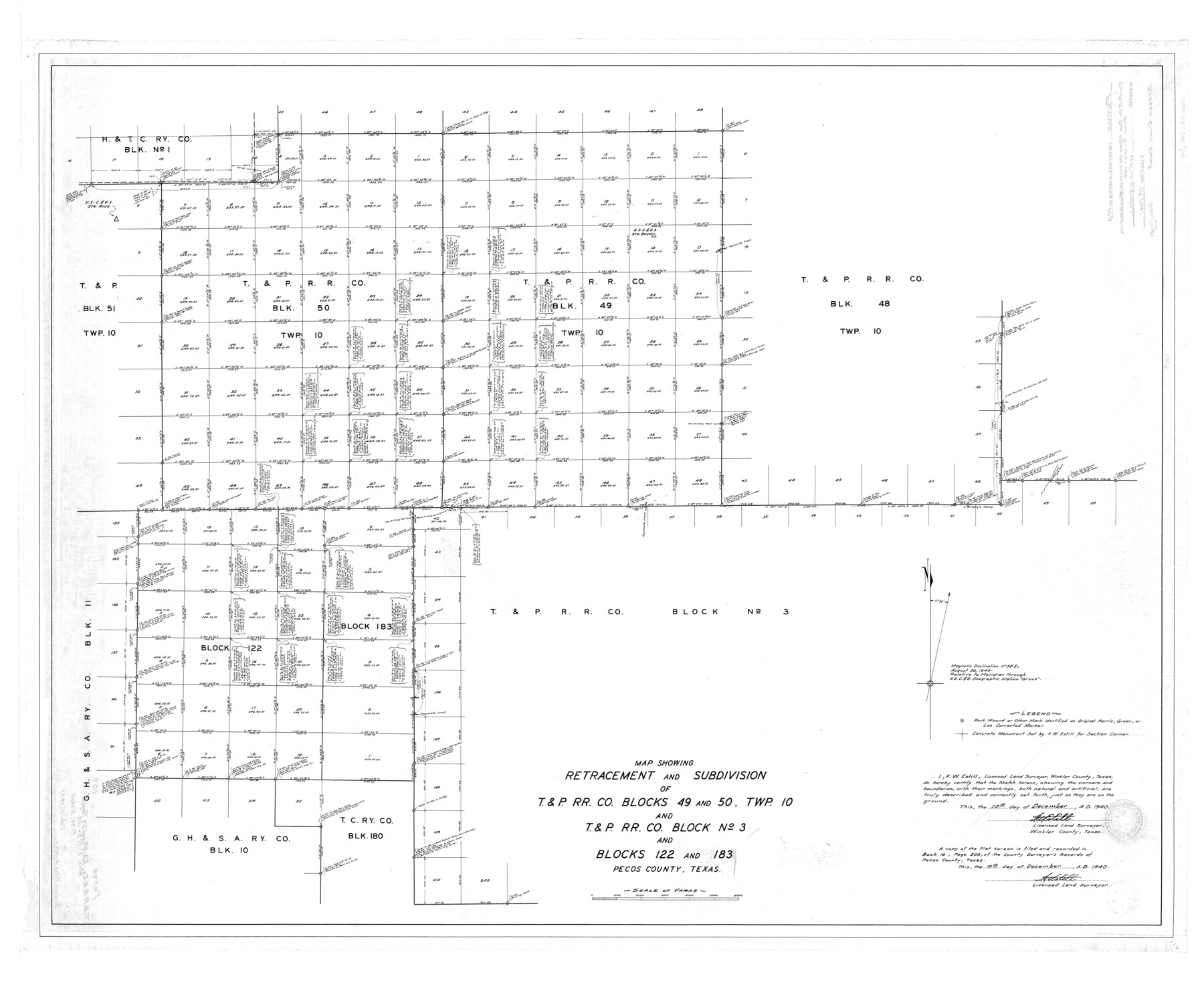
Pecos County Rolled Sketch 109
Map showing retracement and subdivision of T. & P. R.R. Co. Blocks 49 and 50, Twp. 10 and T. & P. R.R. Co. Block no. 3 and Blocks 122 and 183, Pecos County, Texas
-
Map/Doc
9719
-
Collection
General Map Collection
-
Object Dates
1941 (File Date)
1940/12/10 (Creation Date)
-
People and Organizations
F.W. Estill (Surveyor/Engineer)
-
Counties
Pecos
-
Subjects
Surveying Rolled Sketch
-
Height x Width
40.6 x 49.3 inches
103.1 x 125.2 cm
Part of: General Map Collection
Lynn County Boundary File 1

Print $10.00
- Digital $50.00
Lynn County Boundary File 1
Size 14.2 x 8.7 inches
Map/Doc 56617

[Sketch for Mineral Application 24072, San Jacinto River]
![65592, [Sketch for Mineral Application 24072, San Jacinto River], General Map Collection](https://historictexasmaps.com/wmedia_w700/maps/65592.tif.jpg)
Print $20.00
- Digital $50.00
[Sketch for Mineral Application 24072, San Jacinto River]
1929
Size 39.7 x 21.0 inches
Map/Doc 65592
Harris County Sketch File 13a

Print $4.00
- Digital $50.00
Harris County Sketch File 13a
1860
Size 10.8 x 6.0 inches
Map/Doc 25357

Brazos Santiago, Texas

Print $20.00
- Digital $50.00
Brazos Santiago, Texas
1882
Size 9.0 x 16.9 inches
Map/Doc 97186
Austin County Working Sketch 8

Print $20.00
- Digital $50.00
Austin County Working Sketch 8
1992
Size 28.7 x 31.6 inches
Map/Doc 67249

Fannin County Sketch File 14

Print $6.00
- Digital $50.00
Fannin County Sketch File 14
1866
Size 14.5 x 9.6 inches
Map/Doc 22464
Hutchinson County Sketch File 49

Print $30.00
- Digital $50.00
Hutchinson County Sketch File 49
1992
Size 14.2 x 8.6 inches
Map/Doc 27419
Nolan County Sketch File 9

Print $26.00
- Digital $50.00
Nolan County Sketch File 9
1902
Size 14.3 x 9.0 inches
Map/Doc 32465
Coke County Rolled Sketch 16

Print $20.00
- Digital $50.00
Coke County Rolled Sketch 16
1950
Size 44.0 x 34.3 inches
Map/Doc 8630
You may also like
Flight Mission No. BRE-2P, Frame 66, Nueces County

Print $20.00
- Digital $50.00
Flight Mission No. BRE-2P, Frame 66, Nueces County
1956
Size 18.6 x 22.5 inches
Map/Doc 86761
Kenedy County Working Sketch Graphic Index

Print $20.00
- Digital $50.00
Kenedy County Working Sketch Graphic Index
1978
Size 46.6 x 35.8 inches
Map/Doc 76603
Live Oak County Sketch File 11b

Print $6.00
- Digital $50.00
Live Oak County Sketch File 11b
Size 8.2 x 12.6 inches
Map/Doc 30267
Platt [sic] of Late Surveys on Carancahua, Jackson County
![78360, Platt [sic] of Late Surveys on Carancahua, Jackson County, General Map Collection](https://historictexasmaps.com/wmedia_w700/maps/78360.tif.jpg)
Print $2.00
- Digital $50.00
Platt [sic] of Late Surveys on Carancahua, Jackson County
Size 10.9 x 8.0 inches
Map/Doc 78360
Flight Mission No. BRE-1P, Frame 128, Nueces County

Print $20.00
- Digital $50.00
Flight Mission No. BRE-1P, Frame 128, Nueces County
1956
Size 18.3 x 22.1 inches
Map/Doc 86694
Refugio County NRC Article 33.136 Sketch 2

Print $26.00
- Digital $50.00
Refugio County NRC Article 33.136 Sketch 2
2003
Size 24.5 x 36.5 inches
Map/Doc 78536
Cottle County Working Sketch 24

Print $20.00
- Digital $50.00
Cottle County Working Sketch 24
2014
Size 10.6 x 18.3 inches
Map/Doc 93707
Tarrant County Working Sketch 1

Print $20.00
- Digital $50.00
Tarrant County Working Sketch 1
1939
Size 12.2 x 18.9 inches
Map/Doc 62418
Map of Martinsburg Property, Gillespie Co., Tex.

Print $20.00
- Digital $50.00
Map of Martinsburg Property, Gillespie Co., Tex.
Size 15.7 x 13.6 inches
Map/Doc 446
Montgomery County Working Sketch 26

Print $20.00
- Digital $50.00
Montgomery County Working Sketch 26
1941
Size 40.8 x 30.7 inches
Map/Doc 71133
Panola County Working Sketch 30

Print $20.00
- Digital $50.00
Panola County Working Sketch 30
1981
Map/Doc 71439
Guadalupe County Working Sketch 6

Print $20.00
- Digital $50.00
Guadalupe County Working Sketch 6
1948
Size 24.0 x 19.7 inches
Map/Doc 63315