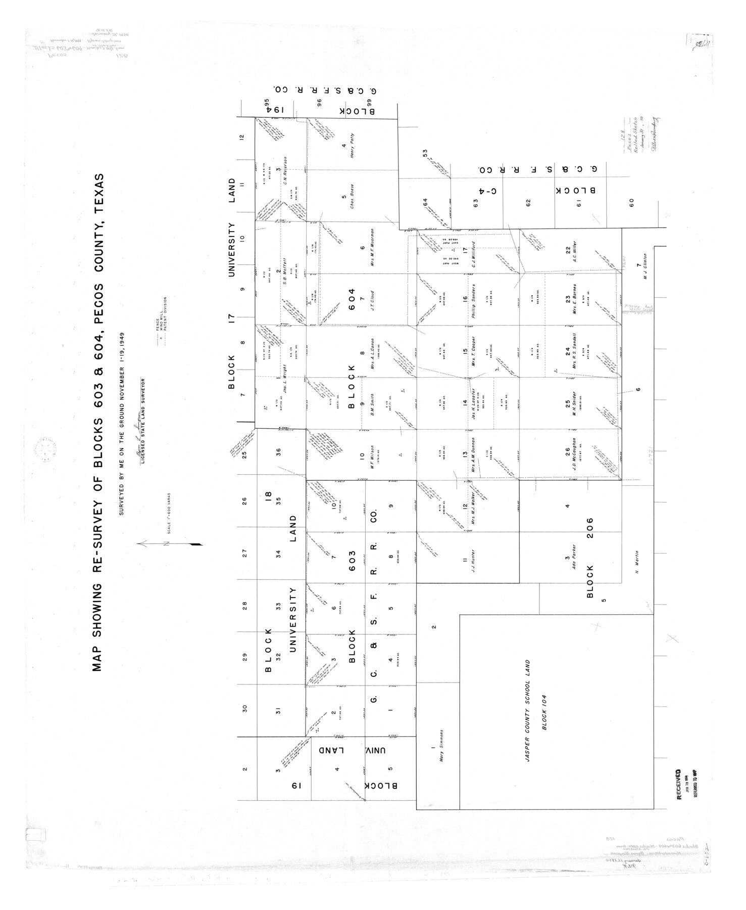
Pecos County Rolled Sketch 128
Map showing re-survey of Blocks 603 & 604, Pecos County, Texas
-
Map/Doc
9725
-
Collection
General Map Collection
-
Object Dates
11/19/1949 (Creation Date)
1/31/1950 (File Date)
-
People and Organizations
Byron L. Simpson (Surveyor/Engineer)
-
Counties
Pecos
-
Subjects
Surveying Rolled Sketch
-
Height x Width
43.6 x 54.0 inches
110.7 x 137.2 cm
-
Scale
1" = 600 varas
Part of: General Map Collection
Wichita County Sketch File 3

Print $8.00
- Digital $50.00
Wichita County Sketch File 3
1856
Size 7.2 x 16.3 inches
Map/Doc 40033
Cass County Sketch File 25

Print $14.00
- Digital $50.00
Cass County Sketch File 25
1936
Size 14.3 x 8.9 inches
Map/Doc 17444
Brazoria County Rolled Sketch AH

Print $20.00
- Digital $50.00
Brazoria County Rolled Sketch AH
Size 43.9 x 31.2 inches
Map/Doc 10714
Presidio County Sketch File 83

Print $8.00
- Digital $50.00
Presidio County Sketch File 83
1949
Size 11.3 x 8.8 inches
Map/Doc 34722

Borden County Boundary File 5a

Print $98.00
- Digital $50.00
Borden County Boundary File 5a
Size 13.3 x 8.1 inches
Map/Doc 50659
Jasper County Sketch File 6

Print $26.00
- Digital $50.00
Jasper County Sketch File 6
1867
Size 12.8 x 8.2 inches
Map/Doc 27771

Red River County Working Sketch 39

Print $20.00
- Digital $50.00
Red River County Working Sketch 39
1967
Size 33.4 x 23.8 inches
Map/Doc 72022
Trinity River, Clear Lake Sheet/East Fork of Trinity River and Pilot Grove Creek

Print $6.00
- Digital $50.00
Trinity River, Clear Lake Sheet/East Fork of Trinity River and Pilot Grove Creek
1923
Size 33.0 x 31.1 inches
Map/Doc 65194
Kerr County Working Sketch 18

Print $20.00
- Digital $50.00
Kerr County Working Sketch 18
1956
Size 25.4 x 29.3 inches
Map/Doc 70049
Newton County Working Sketch 17

Print $20.00
- Digital $50.00
Newton County Working Sketch 17
1950
Size 15.1 x 23.0 inches
Map/Doc 71263
You may also like
A Traveler's Map of Spain and Portugal

A Traveler's Map of Spain and Portugal
Size 36.1 x 22.9 inches
Map/Doc 95937
Aransas County Sketch File 24a

Print $42.00
- Digital $50.00
Aransas County Sketch File 24a
1941
Size 11.6 x 8.6 inches
Map/Doc 13195
Palo Pinto County Working Sketch 11

Print $20.00
- Digital $50.00
Palo Pinto County Working Sketch 11
1942
Size 21.2 x 22.1 inches
Map/Doc 71394
No. 2 Chart of Corpus Christi Pass, Texas

Print $20.00
- Digital $50.00
No. 2 Chart of Corpus Christi Pass, Texas
1878
Size 18.2 x 27.2 inches
Map/Doc 73029
Texas Urbanization and Population Density

Texas Urbanization and Population Density
1976
Size 19.3 x 23.9 inches
Map/Doc 93729
Archer County

Print $20.00
- Digital $50.00
Archer County
1926
Size 43.8 x 38.7 inches
Map/Doc 77202
Dimmit County Working Sketch 25

Print $20.00
- Digital $50.00
Dimmit County Working Sketch 25
1955
Size 24.9 x 18.3 inches
Map/Doc 68686
Flight Mission No. DAG-23K, Frame 142, Matagorda County

Print $20.00
- Digital $50.00
Flight Mission No. DAG-23K, Frame 142, Matagorda County
1953
Size 18.4 x 22.4 inches
Map/Doc 86490
Map of Galveston West Bay and Part of Galveston Island

Print $40.00
- Digital $50.00
Map of Galveston West Bay and Part of Galveston Island
1851
Size 31.2 x 52.6 inches
Map/Doc 69923
Fisher County Boundary File 1

Print $16.00
- Digital $50.00
Fisher County Boundary File 1
Size 12.8 x 8.4 inches
Map/Doc 53411
Bailey County Sketch File 19

Print $8.00
- Digital $50.00
Bailey County Sketch File 19
1882
Size 13.2 x 8.4 inches
Map/Doc 13987
