Galveston County NRC Article 33.136 Sketch 100
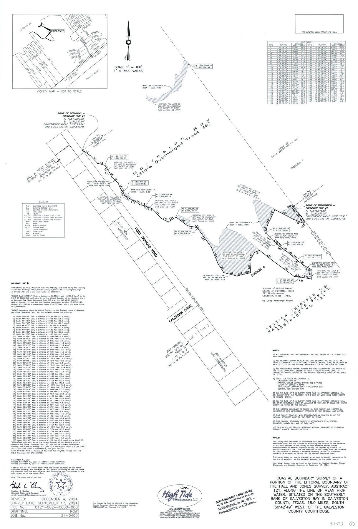
Survey of a portion of the littoral boundary of the Hall and Jones Survey, A-121, along the line of mean high water, situated on the southerly bank of Galveston Bay
-
Map/Doc
97423
-
Collection
General Map Collection
-
Object Dates
9/17/2024 (Creation Date)
11/13/2024 (Revision Date)
12/4/2024 (Revision Date)
4/15/2025 (File Date)
-
People and Organizations
Stephen C. Blaskey (Surveyor/Engineer)
-
Counties
Galveston
-
Subjects
Surveying CBS
-
Comments
Project: Hall and Jones, Sec. 13, Division 4
Project No. SWG-2023-00293
A copy of the survey has been filed under Instrument No. SLS2025000003, Galveston County Surveyors Records.
Includes Fill Map.
Part of: General Map Collection

Brown County Working Sketch 17

Print $20.00
- Digital $50.00
Brown County Working Sketch 17
1993
Size 25.6 x 29.4 inches
Map/Doc 67782
Kimble County Working Sketch 79

Print $20.00
- Digital $50.00
Kimble County Working Sketch 79
1971
Size 34.7 x 31.9 inches
Map/Doc 70147
Section IX, Galveston Harbor and Bar

Print $20.00
- Digital $50.00
Section IX, Galveston Harbor and Bar
1850
Size 30.0 x 45.7 inches
Map/Doc 69855
Ward County Rolled Sketch PMY

Print $40.00
- Digital $50.00
Ward County Rolled Sketch PMY
1935
Size 14.4 x 74.5 inches
Map/Doc 10104
Tom Green County Sketch File 14

Print $20.00
- Digital $50.00
Tom Green County Sketch File 14
Size 34.8 x 45.7 inches
Map/Doc 10401
Jefferson County Working Sketch Graphic Index

Print $20.00
- Digital $50.00
Jefferson County Working Sketch Graphic Index
1978
Size 47.1 x 41.4 inches
Map/Doc 76595
Flight Mission No. CRC-2R, Frame 201, Chambers County

Print $20.00
- Digital $50.00
Flight Mission No. CRC-2R, Frame 201, Chambers County
1956
Size 18.5 x 22.3 inches
Map/Doc 84779
Galveston County Rolled Sketch 10

Print $20.00
- Digital $50.00
Galveston County Rolled Sketch 10
1916
Size 21.0 x 38.0 inches
Map/Doc 5952
Kerr County Working Sketch 14

Print $20.00
- Digital $50.00
Kerr County Working Sketch 14
1952
Size 26.5 x 24.5 inches
Map/Doc 70045
Tyler County Working Sketch 22

Print $20.00
- Digital $50.00
Tyler County Working Sketch 22
1987
Size 42.0 x 35.5 inches
Map/Doc 69492
Map of Location of the Pecos & Northern Texas Railway from Station 7879+36 to Station 8010+08 = 2.48 Miles through Castro County, Texas

Print $20.00
- Digital $50.00
Map of Location of the Pecos & Northern Texas Railway from Station 7879+36 to Station 8010+08 = 2.48 Miles through Castro County, Texas
1898
Size 14.1 x 25.3 inches
Map/Doc 64060
You may also like
Boyd-Gordon Addition to Idalou, a Subdivision of a Part Tracts 27, 28, 29 and 30 of the Ross Addition to Idalou

Print $3.00
- Digital $50.00
Boyd-Gordon Addition to Idalou, a Subdivision of a Part Tracts 27, 28, 29 and 30 of the Ross Addition to Idalou
1953
Size 11.8 x 17.8 inches
Map/Doc 92873
Knox County Rolled Sketch 21

Print $20.00
- Digital $50.00
Knox County Rolled Sketch 21
1955
Size 18.0 x 36.4 inches
Map/Doc 6561
McMullen County Sketch File 44

Print $6.00
- Digital $50.00
McMullen County Sketch File 44
1942
Size 14.2 x 8.8 inches
Map/Doc 31426
Flight Mission No. DCL-7C, Frame 110, Kenedy County

Print $20.00
- Digital $50.00
Flight Mission No. DCL-7C, Frame 110, Kenedy County
1943
Size 18.5 x 22.3 inches
Map/Doc 86075
Johnson County Rolled Sketch 2

Print $20.00
- Digital $50.00
Johnson County Rolled Sketch 2
1956
Size 20.6 x 22.3 inches
Map/Doc 6447
McCulloch County Boundary File 64

Print $36.00
- Digital $50.00
McCulloch County Boundary File 64
Size 9.2 x 8.9 inches
Map/Doc 56919
Fannin County Boundary File 10a and 10b and 10c

Print $4.00
- Digital $50.00
Fannin County Boundary File 10a and 10b and 10c
Size 11.2 x 9.0 inches
Map/Doc 53328
Ochiltree County Boundary File 8

Print $8.00
- Digital $50.00
Ochiltree County Boundary File 8
Size 11.2 x 8.7 inches
Map/Doc 57716

Floyd County Working Sketch 3

Print $20.00
- Digital $50.00
Floyd County Working Sketch 3
1948
Size 27.4 x 22.8 inches
Map/Doc 69182

Foard County Sketch File XX

Print $40.00
- Digital $50.00
Foard County Sketch File XX
1884
Size 14.0 x 16.4 inches
Map/Doc 22802