
Colton's Map of United States, the Canadas & c. showing the Railraods, Canals & Stage Roads with distances from place to place

Print $20.00
- Digital $50.00
Colton's Map of United States, the Canadas & c. showing the Railraods, Canals & Stage Roads with distances from place to place
Size: 28.8 x 33.0 inches
93983
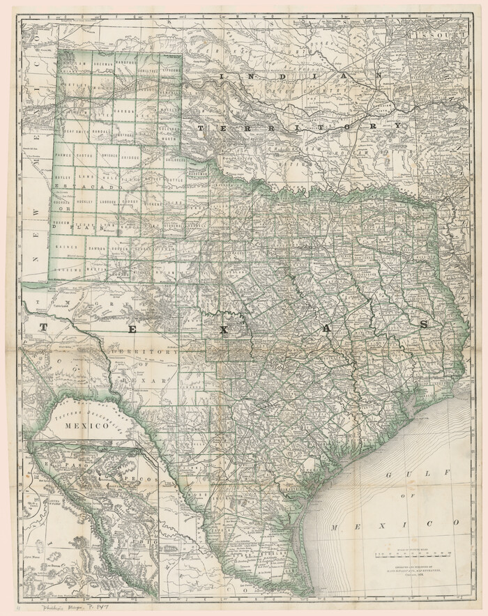
J. De Cordova's Map of the State of Texas Compiled from the records of the General Land Office of the State

Print $20.00
- Digital $50.00
J. De Cordova's Map of the State of Texas Compiled from the records of the General Land Office of the State
Size: 38.5 x 36.4 inches
93984
A New Map of Nebraska, Kansas, New Mexico and Indian Territories

Print $20.00
- Digital $50.00
A New Map of Nebraska, Kansas, New Mexico and Indian Territories
Size: 18.6 x 15.2 inches
93985
Langtree's New Sectional Map of the State of Arkansas

Print $20.00
- Digital $50.00
Langtree's New Sectional Map of the State of Arkansas
Size: 34.6 x 38.4 inches
93987
Geological Map of the United States and the British Provinces of North America

Print $20.00
- Digital $50.00
Geological Map of the United States and the British Provinces of North America
Size: 23.4 x 35.9 inches
93988
Minnesota Route the shortest and best to the Idaho Gold Mines

Print $20.00
- Digital $50.00
Minnesota Route the shortest and best to the Idaho Gold Mines
Size: 21.0 x 46.3 inches
93989
A New Map of Texas, Oregon and California with the regions adjoining, compiled from the most recent authorities

Print $20.00
- Digital $50.00
A New Map of Texas, Oregon and California with the regions adjoining, compiled from the most recent authorities
Size: 22.8 x 20.9 inches
93990
New Map of the Mining Regions of Idaho and Montana showing the geographical positions of the Blackfoot, Owyhee & South Boise Mines and the various routes thereto

Print $20.00
- Digital $50.00
New Map of the Mining Regions of Idaho and Montana showing the geographical positions of the Blackfoot, Owyhee & South Boise Mines and the various routes thereto
Size: 21.9 x 29.4 inches
93991
[Rand McNally's Indexed Map of Texas and Indian Territory]
Print $20.00
- Digital $50.00
[Rand McNally's Indexed Map of Texas and Indian Territory]
Size: 26.0 x 20.6 inches
93992
The Rand-McNally New Commercial Atlas Map of Texas

Print $20.00
- Digital $50.00
The Rand-McNally New Commercial Atlas Map of Texas
Size: 29.5 x 40.3 inches
93993
Kansas and Nebraska

Print $20.00
- Digital $50.00
Kansas and Nebraska
Size: 30.8 x 19.4 inches
93994
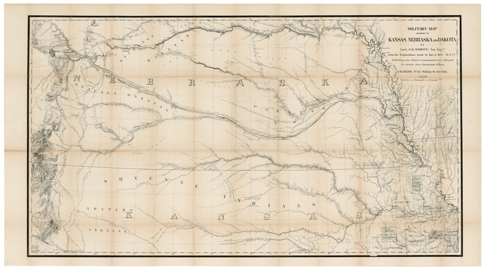
Military Map of parts of Kansas, Nebraska and Dakota by Lieut. G.K. Warren, Top. Engrs. from the Explorations made by him in 1855, 56 & 57 exhibiting also routes reconnouered [sic] and surveyed by various other government officers
Print $20.00
- Digital $50.00
Military Map of parts of Kansas, Nebraska and Dakota by Lieut. G.K. Warren, Top. Engrs. from the Explorations made by him in 1855, 56 & 57 exhibiting also routes reconnouered [sic] and surveyed by various other government officers
Size: 19.9 x 35.6 inches
93995
A New Map of the United States upon which are delineated its vast works of internal communication, routes across the continent &c. showing also Canada and the Island of Cuba

Print $20.00
- Digital $50.00
A New Map of the United States upon which are delineated its vast works of internal communication, routes across the continent &c. showing also Canada and the Island of Cuba
Size: 25.8 x 30.6 inches
93996
Nebraska and Kansas

Print $20.00
- Digital $50.00
Nebraska and Kansas
Size: 14.7 x 16.7 inches
93997
A Map of the United States of Mexico as organized and defined by the several Acts of the Congress of that Republic

Print $20.00
- Digital $50.00
A Map of the United States of Mexico as organized and defined by the several Acts of the Congress of that Republic
1826
Size: 23.9 x 31.2 inches
93939
Mapa de los Estados Unidos de Méjico, Segun lo organizado y definido por las varias actas del Congreso de dicha Republica: y construido por las mejores autoridades

Print $20.00
- Digital $50.00
Mapa de los Estados Unidos de Méjico, Segun lo organizado y definido por las varias actas del Congreso de dicha Republica: y construido por las mejores autoridades
1828
Size: 30.2 x 42.2 inches
93933
Nouvelle carte du Mexique, du Texas et d'une partie des États Limitrophes

Print $20.00
- Digital $50.00
Nouvelle carte du Mexique, du Texas et d'une partie des États Limitrophes
1834
Size: 39.5 x 27.2 inches
93764
Map of Texas With Parts of the Adjoining States

Print $20.00
- Digital $50.00
Map of Texas With Parts of the Adjoining States
1836
Size: 30.9 x 24.8 inches
93932
Map of Texas, compiled from surveys on record in the General Land Office of the Republic to the year 1839

Print $20.00
- Digital $50.00
Map of Texas, compiled from surveys on record in the General Land Office of the Republic to the year 1839
1839
Size: 33.1 x 25.8 inches
93986
A New Map of Texas with the Contiguous American & Mexican States

Print $20.00
- Digital $50.00
A New Map of Texas with the Contiguous American & Mexican States
1839
Size: 13.5 x 16.1 inches
93941
Chart of the Antarctic Continent shewing the icy barrier attached to it discovered by the U.S. Ex. Ex.

Print $20.00
- Digital $50.00
Chart of the Antarctic Continent shewing the icy barrier attached to it discovered by the U.S. Ex. Ex.
1840
Size: 26.5 x 37.2 inches
94058
Chart of the Antarctic Continent shewing the icy barrier attached to it discovered by the U.S. Ex. Ex.

Print $20.00
- Digital $50.00
Chart of the Antarctic Continent shewing the icy barrier attached to it discovered by the U.S. Ex. Ex.
1840
Size: 26.5 x 37.2 inches
94059
Map of the Oregon Territory by the U.S. Ex. Ex.

Print $20.00
- Digital $50.00
Map of the Oregon Territory by the U.S. Ex. Ex.
1841
Size: 26.2 x 37.3 inches
94060
Map of part of the island of Hawaii Sandwich Islands shewing the craters and eruption of May and June 1840 by the U.S. Ex. Ex.

Print $20.00
- Digital $50.00
Map of part of the island of Hawaii Sandwich Islands shewing the craters and eruption of May and June 1840 by the U.S. Ex. Ex.
1841
Size: 18.4 x 25.9 inches
94061
Sabine Pass and mouth of the River Sabine in the sea

Print $20.00
- Digital $50.00
Sabine Pass and mouth of the River Sabine in the sea
1842
Size: 24.0 x 19.1 inches
93766
Map of the River Sabine from its mouth on the Gulf of Mexico in the sea to Logan's Ferry

Print $20.00
- Digital $50.00
Map of the River Sabine from its mouth on the Gulf of Mexico in the sea to Logan's Ferry
1842
Size: 37.5 x 9.4 inches
93767
Map of the River Sabine from Logan's Ferry to 32nd degree of north latitude

Print $3.00
- Digital $50.00
Map of the River Sabine from Logan's Ferry to 32nd degree of north latitude
1842
Size: 8.7 x 11.6 inches
93768
Part of the boundary between the United States and Texas; from Sabine River northward to the 36th mile mound

Print $2.00
- Digital $50.00
Part of the boundary between the United States and Texas; from Sabine River northward to the 36th mile mound
1842
Size: 12.5 x 7.6 inches
93769
Part of the boundary between the United States and Texas; north of Sabine River from the 36th to the 72nd mile mound

Print $3.00
- Digital $50.00
Part of the boundary between the United States and Texas; north of Sabine River from the 36th to the 72nd mile mound
1842
Size: 12.0 x 8.8 inches
93770
Colton's Map of United States, the Canadas & c. showing the Railraods, Canals & Stage Roads with distances from place to place
Print $20.00
- Digital $50.00
Colton's Map of United States, the Canadas & c. showing the Railraods, Canals & Stage Roads with distances from place to place
-
Size
28.8 x 33.0 inches
-
Map/Doc
93983
J. De Cordova's Map of the State of Texas Compiled from the records of the General Land Office of the State
Print $20.00
- Digital $50.00
J. De Cordova's Map of the State of Texas Compiled from the records of the General Land Office of the State
-
Size
38.5 x 36.4 inches
-
Map/Doc
93984
A New Map of Nebraska, Kansas, New Mexico and Indian Territories
Print $20.00
- Digital $50.00
A New Map of Nebraska, Kansas, New Mexico and Indian Territories
-
Size
18.6 x 15.2 inches
-
Map/Doc
93985
Langtree's New Sectional Map of the State of Arkansas
Print $20.00
- Digital $50.00
Langtree's New Sectional Map of the State of Arkansas
-
Size
34.6 x 38.4 inches
-
Map/Doc
93987
Geological Map of the United States and the British Provinces of North America
Print $20.00
- Digital $50.00
Geological Map of the United States and the British Provinces of North America
-
Size
23.4 x 35.9 inches
-
Map/Doc
93988
Minnesota Route the shortest and best to the Idaho Gold Mines
Print $20.00
- Digital $50.00
Minnesota Route the shortest and best to the Idaho Gold Mines
-
Size
21.0 x 46.3 inches
-
Map/Doc
93989
A New Map of Texas, Oregon and California with the regions adjoining, compiled from the most recent authorities
Print $20.00
- Digital $50.00
A New Map of Texas, Oregon and California with the regions adjoining, compiled from the most recent authorities
-
Size
22.8 x 20.9 inches
-
Map/Doc
93990
New Map of the Mining Regions of Idaho and Montana showing the geographical positions of the Blackfoot, Owyhee & South Boise Mines and the various routes thereto
Print $20.00
- Digital $50.00
New Map of the Mining Regions of Idaho and Montana showing the geographical positions of the Blackfoot, Owyhee & South Boise Mines and the various routes thereto
-
Size
21.9 x 29.4 inches
-
Map/Doc
93991
[Rand McNally's Indexed Map of Texas and Indian Territory]
Print $20.00
- Digital $50.00
[Rand McNally's Indexed Map of Texas and Indian Territory]
-
Size
26.0 x 20.6 inches
-
Map/Doc
93992
The Rand-McNally New Commercial Atlas Map of Texas
Print $20.00
- Digital $50.00
The Rand-McNally New Commercial Atlas Map of Texas
-
Size
29.5 x 40.3 inches
-
Map/Doc
93993
Kansas and Nebraska
Print $20.00
- Digital $50.00
Kansas and Nebraska
-
Size
30.8 x 19.4 inches
-
Map/Doc
93994
Military Map of parts of Kansas, Nebraska and Dakota by Lieut. G.K. Warren, Top. Engrs. from the Explorations made by him in 1855, 56 & 57 exhibiting also routes reconnouered [sic] and surveyed by various other government officers
Print $20.00
- Digital $50.00
Military Map of parts of Kansas, Nebraska and Dakota by Lieut. G.K. Warren, Top. Engrs. from the Explorations made by him in 1855, 56 & 57 exhibiting also routes reconnouered [sic] and surveyed by various other government officers
-
Size
19.9 x 35.6 inches
-
Map/Doc
93995
A New Map of the United States upon which are delineated its vast works of internal communication, routes across the continent &c. showing also Canada and the Island of Cuba
Print $20.00
- Digital $50.00
A New Map of the United States upon which are delineated its vast works of internal communication, routes across the continent &c. showing also Canada and the Island of Cuba
-
Size
25.8 x 30.6 inches
-
Map/Doc
93996
Nebraska and Kansas
Print $20.00
- Digital $50.00
Nebraska and Kansas
-
Size
14.7 x 16.7 inches
-
Map/Doc
93997
A Map of the United States of Mexico as organized and defined by the several Acts of the Congress of that Republic
Print $20.00
- Digital $50.00
A Map of the United States of Mexico as organized and defined by the several Acts of the Congress of that Republic
1826
-
Size
23.9 x 31.2 inches
-
Map/Doc
93939
-
Creation Date
1826
Mapa de los Estados Unidos de Méjico, Segun lo organizado y definido por las varias actas del Congreso de dicha Republica: y construido por las mejores autoridades
Print $20.00
- Digital $50.00
Mapa de los Estados Unidos de Méjico, Segun lo organizado y definido por las varias actas del Congreso de dicha Republica: y construido por las mejores autoridades
1828
-
Size
30.2 x 42.2 inches
-
Map/Doc
93933
-
Creation Date
1828
Nouvelle carte du Mexique, du Texas et d'une partie des États Limitrophes
Print $20.00
- Digital $50.00
Nouvelle carte du Mexique, du Texas et d'une partie des États Limitrophes
1834
-
Size
39.5 x 27.2 inches
-
Map/Doc
93764
-
Creation Date
1834
Map of Texas With Parts of the Adjoining States
Print $20.00
- Digital $50.00
Map of Texas With Parts of the Adjoining States
1836
-
Size
30.9 x 24.8 inches
-
Map/Doc
93932
-
Creation Date
1836
Map of Texas, compiled from surveys on record in the General Land Office of the Republic to the year 1839
Print $20.00
- Digital $50.00
Map of Texas, compiled from surveys on record in the General Land Office of the Republic to the year 1839
1839
-
Size
33.1 x 25.8 inches
-
Map/Doc
93986
-
Creation Date
1839
A New Map of Texas with the Contiguous American & Mexican States
Print $20.00
- Digital $50.00
A New Map of Texas with the Contiguous American & Mexican States
1839
-
Size
13.5 x 16.1 inches
-
Map/Doc
93941
-
Creation Date
1839
Chart of the Antarctic Continent shewing the icy barrier attached to it discovered by the U.S. Ex. Ex.
Print $20.00
- Digital $50.00
Chart of the Antarctic Continent shewing the icy barrier attached to it discovered by the U.S. Ex. Ex.
1840
-
Size
26.5 x 37.2 inches
-
Map/Doc
94058
-
Creation Date
1840
Chart of the Antarctic Continent shewing the icy barrier attached to it discovered by the U.S. Ex. Ex.
Print $20.00
- Digital $50.00
Chart of the Antarctic Continent shewing the icy barrier attached to it discovered by the U.S. Ex. Ex.
1840
-
Size
26.5 x 37.2 inches
-
Map/Doc
94059
-
Creation Date
1840
Map of the Oregon Territory by the U.S. Ex. Ex.
Print $20.00
- Digital $50.00
Map of the Oregon Territory by the U.S. Ex. Ex.
1841
-
Size
26.2 x 37.3 inches
-
Map/Doc
94060
-
Creation Date
1841
Map of part of the island of Hawaii Sandwich Islands shewing the craters and eruption of May and June 1840 by the U.S. Ex. Ex.
Print $20.00
- Digital $50.00
Map of part of the island of Hawaii Sandwich Islands shewing the craters and eruption of May and June 1840 by the U.S. Ex. Ex.
1841
-
Size
18.4 x 25.9 inches
-
Map/Doc
94061
-
Creation Date
1841
Sabine Pass and mouth of the River Sabine in the sea
Print $20.00
- Digital $50.00
Sabine Pass and mouth of the River Sabine in the sea
1842
-
Size
24.0 x 19.1 inches
-
Map/Doc
93766
-
Creation Date
1842
Map of the River Sabine from its mouth on the Gulf of Mexico in the sea to Logan's Ferry
Print $20.00
- Digital $50.00
Map of the River Sabine from its mouth on the Gulf of Mexico in the sea to Logan's Ferry
1842
-
Size
37.5 x 9.4 inches
-
Map/Doc
93767
-
Creation Date
1842
Map of the River Sabine from Logan's Ferry to 32nd degree of north latitude
Print $3.00
- Digital $50.00
Map of the River Sabine from Logan's Ferry to 32nd degree of north latitude
1842
-
Size
8.7 x 11.6 inches
-
Map/Doc
93768
-
Creation Date
1842
Part of the boundary between the United States and Texas; from Sabine River northward to the 36th mile mound
Print $2.00
- Digital $50.00
Part of the boundary between the United States and Texas; from Sabine River northward to the 36th mile mound
1842
-
Size
12.5 x 7.6 inches
-
Map/Doc
93769
-
Creation Date
1842
Part of the boundary between the United States and Texas; north of Sabine River from the 36th to the 72nd mile mound
Print $3.00
- Digital $50.00
Part of the boundary between the United States and Texas; north of Sabine River from the 36th to the 72nd mile mound
1842
-
Size
12.0 x 8.8 inches
-
Map/Doc
93770
-
Creation Date
1842