[Surveys near the Medina River, Bexar District]
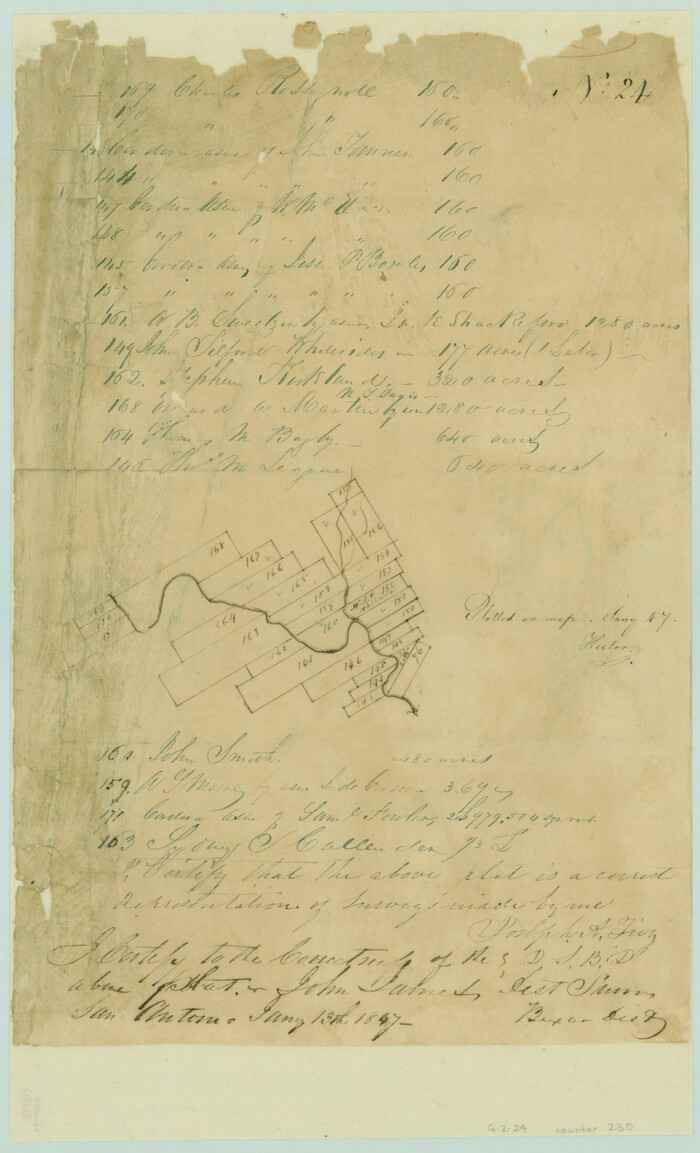
Print $2.00
- Digital $50.00
[Surveys near the Medina River, Bexar District]
1847
Size: 13.1 x 8.0 inches
230
[Surveys near Seco Creek]
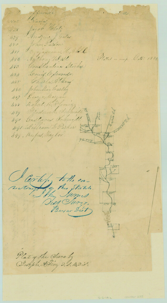
Print $2.00
- Digital $50.00
[Surveys near Seco Creek]
1846
Size: 13.1 x 7.3 inches
225
[Surveys near Hondo Creek]
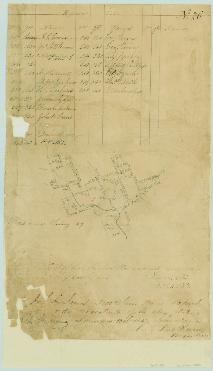
Print $2.00
- Digital $50.00
[Surveys near Hondo Creek]
1847
Size: 13.8 x 8.0 inches
226
[Surveys near Hondo Creek]
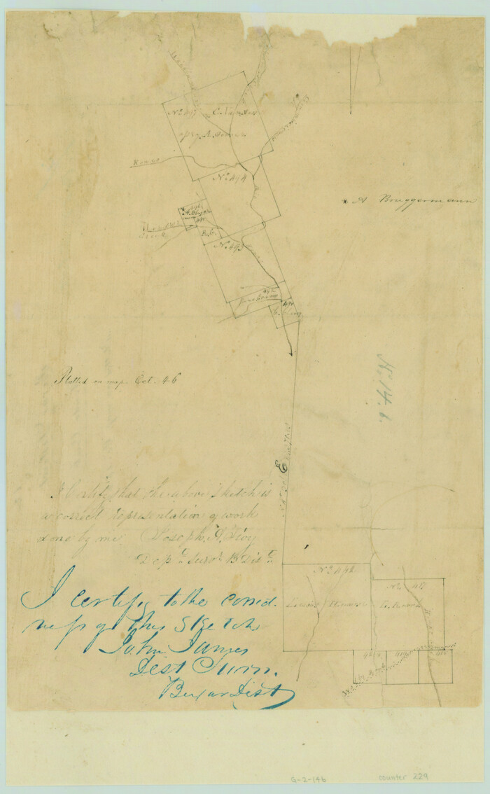
Print $2.00
- Digital $50.00
[Surveys near Hondo Creek]
1846
Size: 11.6 x 7.2 inches
229
[Surveys in the Bexar District along the Medina River]
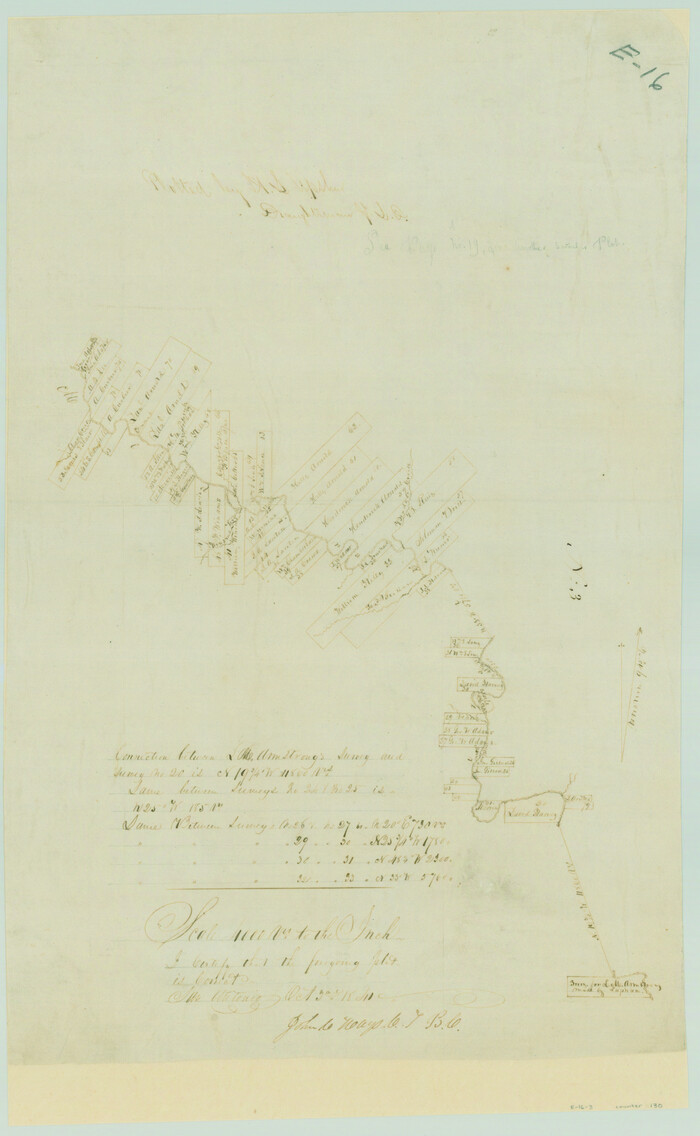
Print $20.00
- Digital $50.00
[Surveys in the Bexar District along the Medina River]
1841
Size: 20.7 x 12.8 inches
130
[Surveys in the Bexar District along the Medina River]
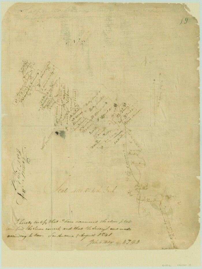
Print $20.00
- Digital $50.00
[Surveys in the Bexar District along the Medina River]
1841
Size: 16.9 x 12.7 inches
17
[Surveys along Verde and Bandera Creeks]
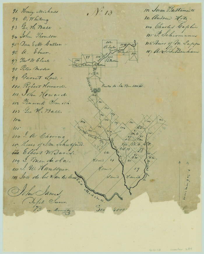
Print $2.00
- Digital $50.00
[Surveys along Verde and Bandera Creeks]
1846
Size: 10.0 x 8.0 inches
289
[Surveying Sketch of Kendall County School Land, et al in Kerr County, Texas]
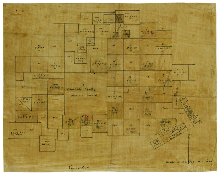
Print $3.00
- Digital $50.00
[Surveying Sketch of Kendall County School Land, et al in Kerr County, Texas]
Size: 11.9 x 12.9 inches
5072
Real County Working Sketch 90

Print $20.00
- Digital $50.00
Real County Working Sketch 90
1991
Size: 16.7 x 22.8 inches
71982
Real County Working Sketch 83

Print $20.00
- Digital $50.00
Real County Working Sketch 83
1986
Size: 25.7 x 43.0 inches
71975
Real County Working Sketch 16

Print $20.00
- Digital $50.00
Real County Working Sketch 16
1941
Size: 28.2 x 40.1 inches
71908
Real County Sketch File 12

Print $20.00
- Digital $50.00
Real County Sketch File 12
1932
Size: 13.9 x 19.2 inches
12231
Real County Sketch File 11

Print $8.00
- Digital $50.00
Real County Sketch File 11
1932
Size: 11.2 x 8.8 inches
35065
Plat of Proposed County

Print $20.00
- Digital $50.00
Plat of Proposed County
1909
Size: 23.9 x 30.8 inches
1712
Nueces River, Water Shed [of the Nueces River]
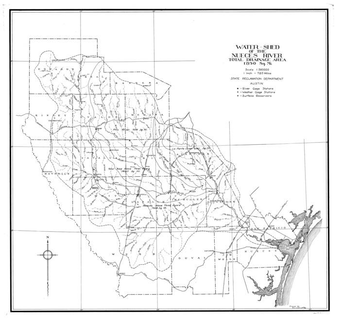
Print $6.00
- Digital $50.00
Nueces River, Water Shed [of the Nueces River]
1925
Size: 33.6 x 35.4 inches
65101
Medina County Working Sketch 33

Print $20.00
- Digital $50.00
Medina County Working Sketch 33
2006
Size: 34.5 x 40.0 inches
83607
Medina County Sketch File 22

Print $38.00
- Digital $50.00
Medina County Sketch File 22
2007
Size: 11.0 x 8.5 inches
93633
Medina County Rolled Sketch 22

Print $20.00
- Digital $50.00
Medina County Rolled Sketch 22
2007
Size: 24.5 x 18.4 inches
88849
Map representing the surveys made in Bexar County

Print $40.00
- Digital $50.00
Map representing the surveys made in Bexar County
1839
Size: 76.0 x 68.4 inches
1947
Map representing the surveys made in Bexar County

Print $40.00
- Digital $50.00
Map representing the surveys made in Bexar County
1839
Size: 75.7 x 37.9 inches
93364
Map representing the surveys made in Bexar County

Print $40.00
- Digital $50.00
Map representing the surveys made in Bexar County
1839
Size: 75.7 x 35.1 inches
93365
Map of Bandera County, Texas

Print $20.00
- Digital $50.00
Map of Bandera County, Texas
1879
Size: 19.6 x 32.6 inches
691
Map of Bandera County

Print $20.00
- Digital $50.00
Map of Bandera County
1862
Size: 19.0 x 30.1 inches
3271
Map of Bandera County

Print $20.00
- Digital $50.00
Map of Bandera County
1878
Size: 19.3 x 29.4 inches
3272
Map of Bandera County

Print $40.00
- Digital $50.00
Map of Bandera County
1885
Size: 31.3 x 60.9 inches
3273
Map of Bandera County

Print $40.00
- Digital $50.00
Map of Bandera County
1885
Size: 33.5 x 64.7 inches
4771
Map of Bandera County

Print $40.00
- Digital $50.00
Map of Bandera County
1885
Size: 31.6 x 63.9 inches
4772
Kerr County Working Sketch 9

Print $20.00
- Digital $50.00
Kerr County Working Sketch 9
1949
Size: 31.6 x 33.0 inches
70040
[Surveys near the Medina River, Bexar District]
Print $2.00
- Digital $50.00
[Surveys near the Medina River, Bexar District]
1847
-
Size
13.1 x 8.0 inches
-
Map/Doc
230
-
Creation Date
1847
[Surveys near Seco Creek]
Print $2.00
- Digital $50.00
[Surveys near Seco Creek]
1846
-
Size
13.1 x 7.3 inches
-
Map/Doc
225
-
Creation Date
1846
[Surveys near Hondo Creek]
Print $2.00
- Digital $50.00
[Surveys near Hondo Creek]
1847
-
Size
13.8 x 8.0 inches
-
Map/Doc
226
-
Creation Date
1847
[Surveys near Hondo Creek]
Print $2.00
- Digital $50.00
[Surveys near Hondo Creek]
1846
-
Size
11.6 x 7.2 inches
-
Map/Doc
229
-
Creation Date
1846
[Surveys in the Bexar District along the Medina River]
Print $20.00
- Digital $50.00
[Surveys in the Bexar District along the Medina River]
1841
-
Size
20.7 x 12.8 inches
-
Map/Doc
130
-
Creation Date
1841
[Surveys in the Bexar District along the Medina River]
Print $20.00
- Digital $50.00
[Surveys in the Bexar District along the Medina River]
1841
-
Size
16.9 x 12.7 inches
-
Map/Doc
17
-
Creation Date
1841
[Surveys along Verde and Bandera Creeks]
Print $2.00
- Digital $50.00
[Surveys along Verde and Bandera Creeks]
1846
-
Size
10.0 x 8.0 inches
-
Map/Doc
289
-
Creation Date
1846
[Surveying Sketch of Kendall County School Land, et al in Kerr County, Texas]
Print $3.00
- Digital $50.00
[Surveying Sketch of Kendall County School Land, et al in Kerr County, Texas]
-
Size
11.9 x 12.9 inches
-
Map/Doc
5072
Texas Hill Country Trail Region

Texas Hill Country Trail Region
2017
-
Size
18.2 x 24.3 inches
-
Map/Doc
96871
-
Creation Date
2017
Texas Hill Country Trail Region

Texas Hill Country Trail Region
-
Size
18.1 x 24.2 inches
-
Map/Doc
96872
Real County Working Sketch 90
Print $20.00
- Digital $50.00
Real County Working Sketch 90
1991
-
Size
16.7 x 22.8 inches
-
Map/Doc
71982
-
Creation Date
1991
Real County Working Sketch 83
Print $20.00
- Digital $50.00
Real County Working Sketch 83
1986
-
Size
25.7 x 43.0 inches
-
Map/Doc
71975
-
Creation Date
1986
Real County Working Sketch 16
Print $20.00
- Digital $50.00
Real County Working Sketch 16
1941
-
Size
28.2 x 40.1 inches
-
Map/Doc
71908
-
Creation Date
1941
Real County Sketch File 12
Print $20.00
- Digital $50.00
Real County Sketch File 12
1932
-
Size
13.9 x 19.2 inches
-
Map/Doc
12231
-
Creation Date
1932
Real County Sketch File 11
Print $8.00
- Digital $50.00
Real County Sketch File 11
1932
-
Size
11.2 x 8.8 inches
-
Map/Doc
35065
-
Creation Date
1932
Plat of Proposed County
Print $20.00
- Digital $50.00
Plat of Proposed County
1909
-
Size
23.9 x 30.8 inches
-
Map/Doc
1712
-
Creation Date
1909
Nueces River, Water Shed [of the Nueces River]
Print $6.00
- Digital $50.00
Nueces River, Water Shed [of the Nueces River]
1925
-
Size
33.6 x 35.4 inches
-
Map/Doc
65101
-
Creation Date
1925
Medina County Working Sketch 33
Print $20.00
- Digital $50.00
Medina County Working Sketch 33
2006
-
Size
34.5 x 40.0 inches
-
Map/Doc
83607
-
Creation Date
2006
Medina County Sketch File 22
Print $38.00
- Digital $50.00
Medina County Sketch File 22
2007
-
Size
11.0 x 8.5 inches
-
Map/Doc
93633
-
Creation Date
2007
Medina County Rolled Sketch 22
Print $20.00
- Digital $50.00
Medina County Rolled Sketch 22
2007
-
Size
24.5 x 18.4 inches
-
Map/Doc
88849
-
Creation Date
2007
Map representing the surveys made in Bexar County
Print $40.00
- Digital $50.00
Map representing the surveys made in Bexar County
1839
-
Size
76.0 x 68.4 inches
-
Map/Doc
1947
-
Creation Date
1839
Map representing the surveys made in Bexar County
Print $40.00
- Digital $50.00
Map representing the surveys made in Bexar County
1839
-
Size
75.7 x 37.9 inches
-
Map/Doc
93364
-
Creation Date
1839
Map representing the surveys made in Bexar County
Print $40.00
- Digital $50.00
Map representing the surveys made in Bexar County
1839
-
Size
75.7 x 35.1 inches
-
Map/Doc
93365
-
Creation Date
1839
Map of Bandera County, Texas
Print $20.00
- Digital $50.00
Map of Bandera County, Texas
1879
-
Size
19.6 x 32.6 inches
-
Map/Doc
691
-
Creation Date
1879
Map of Bandera County
Print $20.00
- Digital $50.00
Map of Bandera County
1862
-
Size
19.0 x 30.1 inches
-
Map/Doc
3271
-
Creation Date
1862
Map of Bandera County
Print $20.00
- Digital $50.00
Map of Bandera County
1878
-
Size
19.3 x 29.4 inches
-
Map/Doc
3272
-
Creation Date
1878
Map of Bandera County
Print $40.00
- Digital $50.00
Map of Bandera County
1885
-
Size
31.3 x 60.9 inches
-
Map/Doc
3273
-
Creation Date
1885
Map of Bandera County
Print $40.00
- Digital $50.00
Map of Bandera County
1885
-
Size
33.5 x 64.7 inches
-
Map/Doc
4771
-
Creation Date
1885
Map of Bandera County
Print $40.00
- Digital $50.00
Map of Bandera County
1885
-
Size
31.6 x 63.9 inches
-
Map/Doc
4772
-
Creation Date
1885
Kerr County Working Sketch 9
Print $20.00
- Digital $50.00
Kerr County Working Sketch 9
1949
-
Size
31.6 x 33.0 inches
-
Map/Doc
70040
-
Creation Date
1949