[T. J. Chambers' grant]
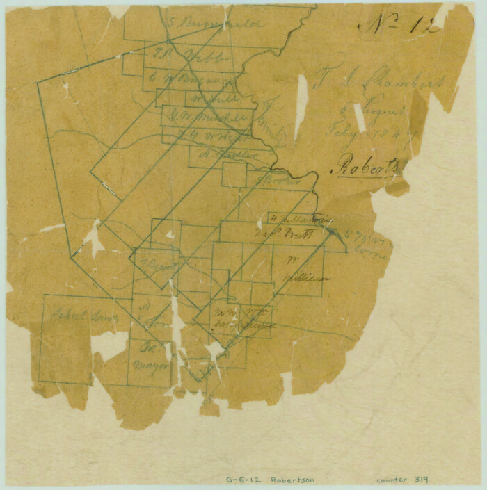
Print $2.00
- Digital $50.00
[T. J. Chambers' grant]
1847
Size: 7.1 x 7.1 inches
319
[Surveys along the Trinity River and below]
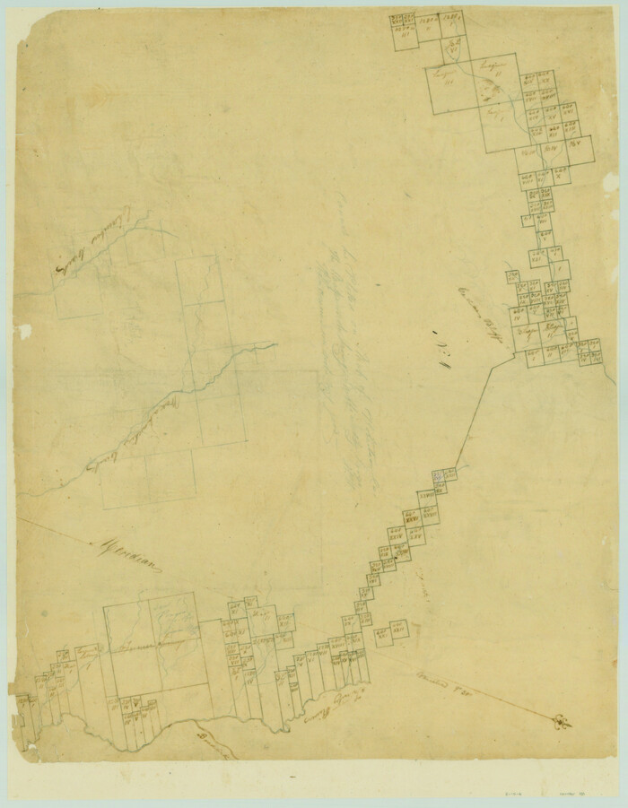
Print $20.00
- Digital $50.00
[Surveys along the Trinity River and below]
1840
Size: 22.6 x 17.6 inches
101
[Surveys along the Nacogdoches River, Richland Creek, and the Trinity River]
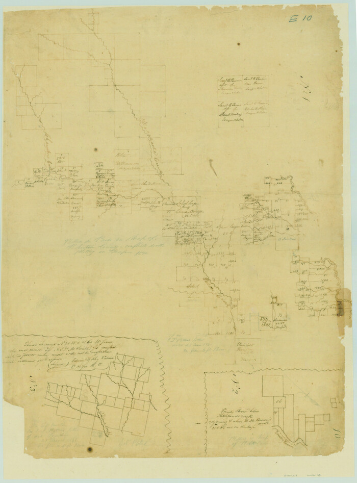
Print $20.00
- Digital $50.00
[Surveys along the Nacogdoches River, Richland Creek, and the Trinity River]
1840
Size: 24.2 x 17.9 inches
85
[Sketch of Col. Cooke's Military Road expedition from Red River to Austin]
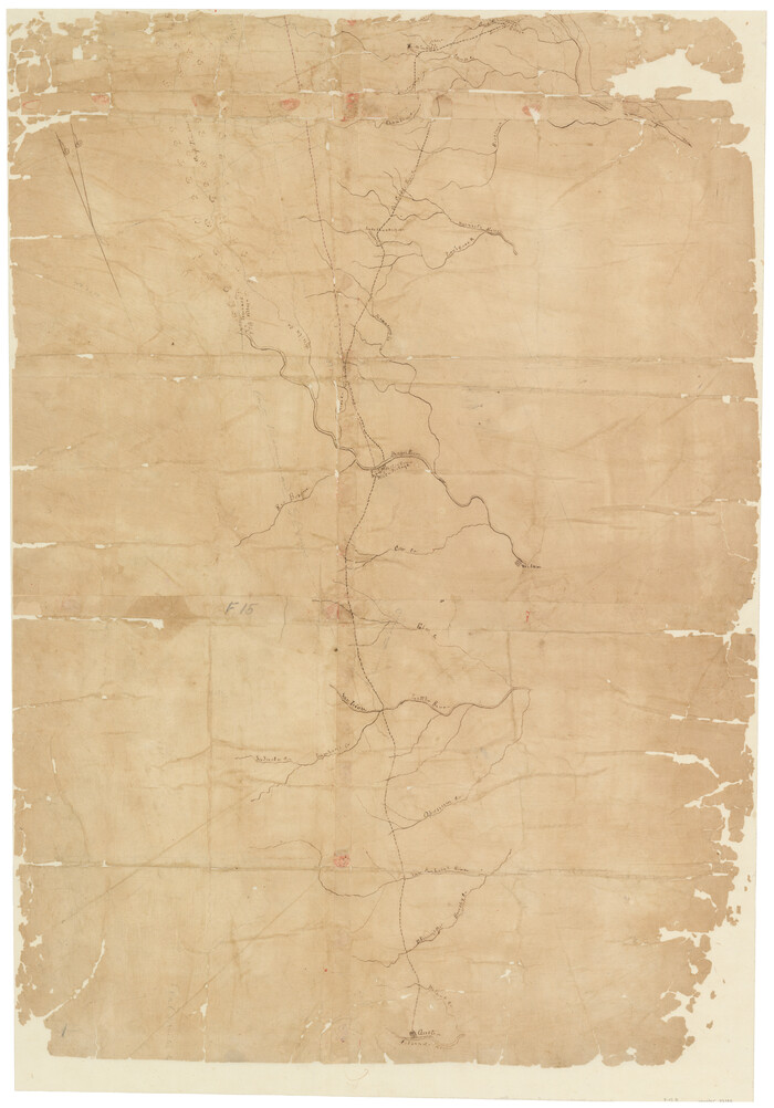
Print $20.00
- Digital $50.00
[Sketch of Col. Cooke's Military Road expedition from Red River to Austin]
Size: 33.4 x 23.4 inches
82146
Trinity River, Waxahachie Sheet/Waxahachie Creek

Print $6.00
- Digital $50.00
Trinity River, Waxahachie Sheet/Waxahachie Creek
1931
Size: 30.1 x 32.8 inches
65237
Trinity River, Slate Rock Ferry Sheet/East Fork of Trinity River

Print $6.00
- Digital $50.00
Trinity River, Slate Rock Ferry Sheet/East Fork of Trinity River
1922
Size: 35.1 x 34.3 inches
65185
Trinity River, Sand Lake Sheet

Print $40.00
- Digital $50.00
Trinity River, Sand Lake Sheet
1922
Size: 29.4 x 49.7 inches
65184
Trinity River, Red Bank Sheet

Print $20.00
- Digital $50.00
Trinity River, Red Bank Sheet
1925
Size: 16.4 x 24.4 inches
69687
Trinity River, Reagor Springs Sheet/Waxahachie Creek

Print $4.00
- Digital $50.00
Trinity River, Reagor Springs Sheet/Waxahachie Creek
1931
Size: 29.9 x 25.6 inches
65236
Trinity River, Onion Creek Station Sheet/Chambers Creek

Print $6.00
- Digital $50.00
Trinity River, Onion Creek Station Sheet/Chambers Creek
1931
Size: 35.1 x 32.4 inches
65234
Trinity River, Levee Improvements, District Widths of Floodways

Print $20.00
- Digital $50.00
Trinity River, Levee Improvements, District Widths of Floodways
1920
Size: 25.0 x 18.6 inches
65252
Trinity River, Levee Improvement Districts, Widths of Floodways

Print $20.00
- Digital $50.00
Trinity River, Levee Improvement Districts, Widths of Floodways
1923
Size: 37.6 x 28.2 inches
65253
Trinity River, Hughes Crossing Sheet/Chambers Creek

Print $6.00
- Digital $50.00
Trinity River, Hughes Crossing Sheet/Chambers Creek
1931
Size: 32.5 x 30.2 inches
65239
Trinity River, Ham Crossing Sheet/Waxahachie Creek

Print $6.00
- Digital $50.00
Trinity River, Ham Crossing Sheet/Waxahachie Creek
1930
Size: 31.4 x 31.1 inches
65235
Trinity River, Extension Crab Tree Ferry Sheet/Red Oak Sheet

Print $4.00
- Digital $50.00
Trinity River, Extension Crab Tree Ferry Sheet/Red Oak Sheet
1922
Size: 17.5 x 25.4 inches
65187
Trinity River, East Fork of Trinity River Levee Improvement Districts/Widths of Floodways as Established by Approved Plans

Print $4.00
- Digital $50.00
Trinity River, East Fork of Trinity River Levee Improvement Districts/Widths of Floodways as Established by Approved Plans
1919
Size: 28.4 x 18.5 inches
65248
Trinity River, Crabtree Ferry Sheet

Print $20.00
- Digital $50.00
Trinity River, Crabtree Ferry Sheet
1922
Size: 41.9 x 37.8 inches
65186
Trinity River, Club House Sheet

Print $20.00
- Digital $50.00
Trinity River, Club House Sheet
1925
Size: 27.7 x 23.7 inches
69688
Trinity River, Boyd Crossing Sheet/Chambers Creek

Print $20.00
- Digital $50.00
Trinity River, Boyd Crossing Sheet/Chambers Creek
1931
Size: 17.5 x 43.1 inches
65238
Southern Pacific Transportation Company Right of Way and Track Map - Main Line

Print $40.00
- Digital $50.00
Southern Pacific Transportation Company Right of Way and Track Map - Main Line
1918
Size: 25.4 x 57.6 inches
82858
Right of Way and Track Map, Houston & Texas Central R.R. operated by the T. and N. O. R.R., Fort Worth Branch

Print $40.00
- Digital $50.00
Right of Way and Track Map, Houston & Texas Central R.R. operated by the T. and N. O. R.R., Fort Worth Branch
1918
Size: 31.6 x 57.2 inches
64780
Right of Way and Track Map, Houston & Texas Central R.R. operated by the T. and N. O. R.R., Fort Worth Branch

Print $40.00
- Digital $50.00
Right of Way and Track Map, Houston & Texas Central R.R. operated by the T. and N. O. R.R., Fort Worth Branch
1918
Size: 31.8 x 57.1 inches
64781
Right of Way and Track Map Houston & Texas Central R.R. operated by the T. and N. O. R.R. Co., Fort Worth Branch

Print $40.00
- Digital $50.00
Right of Way and Track Map Houston & Texas Central R.R. operated by the T. and N. O. R.R. Co., Fort Worth Branch
1918
Size: 31.1 x 57.3 inches
64543
Right of Way and Track Map Houston & Texas Central R.R. operated by the T. and N. O. R.R. Co., Fort Worth Branch

Print $40.00
- Digital $50.00
Right of Way and Track Map Houston & Texas Central R.R. operated by the T. and N. O. R.R. Co., Fort Worth Branch
1918
Size: 31.4 x 58.5 inches
64544
Right of Way and Track Map - Houston & Texas Central R.R. operated by the T. and N. O. R.R. Co. - Main Line

Print $40.00
- Digital $50.00
Right of Way and Track Map - Houston & Texas Central R.R. operated by the T. and N. O. R.R. Co. - Main Line
1918
Size: 26.0 x 58.1 inches
82856
Right of Way and Track Map - Houston & Texas Central R.R. operated by the T. and N. O. R.R. Co. - Main Line

Print $40.00
- Digital $50.00
Right of Way and Track Map - Houston & Texas Central R.R. operated by the T. and N. O. R.R. Co. - Main Line
1918
Size: 25.0 x 57.5 inches
82857
Right of Way and Track Map - Houston & Texas Central R.R. operated by the T. and N. O. R.R. Co. - Main Line

Print $40.00
- Digital $50.00
Right of Way and Track Map - Houston & Texas Central R.R. operated by the T. and N. O. R.R. Co. - Main Line
1918
Size: 25.2 x 57.8 inches
82859
Right of Way and Track Map - Houston & Texas Central R.R. operated by the T. and N. O. R.R. Co. - Fort Worth Branch

Print $40.00
- Digital $50.00
Right of Way and Track Map - Houston & Texas Central R.R. operated by the T. and N. O. R.R. Co. - Fort Worth Branch
1918
Size: 25.3 x 57.3 inches
82860
Right of Way and Track Map - Houston & Texas Central R.R. operated by the T. and N. O. R.R. Co. - Fort Worth Branch

Print $40.00
- Digital $50.00
Right of Way and Track Map - Houston & Texas Central R.R. operated by the T. and N. O. R.R. Co. - Fort Worth Branch
1918
Size: 26.5 x 58.3 inches
82861
Official Map of the City of Waxahachie, Texas
.tif.jpg)
Print $20.00
- Digital $50.00
Official Map of the City of Waxahachie, Texas
1922
Size: 41.4 x 40.8 inches
4841
[T. J. Chambers' grant]
Print $2.00
- Digital $50.00
[T. J. Chambers' grant]
1847
-
Size
7.1 x 7.1 inches
-
Map/Doc
319
-
Creation Date
1847
[Surveys along the Trinity River and below]
Print $20.00
- Digital $50.00
[Surveys along the Trinity River and below]
1840
-
Size
22.6 x 17.6 inches
-
Map/Doc
101
-
Creation Date
1840
[Surveys along the Nacogdoches River, Richland Creek, and the Trinity River]
Print $20.00
- Digital $50.00
[Surveys along the Nacogdoches River, Richland Creek, and the Trinity River]
1840
-
Size
24.2 x 17.9 inches
-
Map/Doc
85
-
Creation Date
1840
[Sketch of Col. Cooke's Military Road expedition from Red River to Austin]
Print $20.00
- Digital $50.00
[Sketch of Col. Cooke's Military Road expedition from Red River to Austin]
-
Size
33.4 x 23.4 inches
-
Map/Doc
82146
Trinity River, Waxahachie Sheet/Waxahachie Creek
Print $6.00
- Digital $50.00
Trinity River, Waxahachie Sheet/Waxahachie Creek
1931
-
Size
30.1 x 32.8 inches
-
Map/Doc
65237
-
Creation Date
1931
Trinity River, Slate Rock Ferry Sheet/East Fork of Trinity River
Print $6.00
- Digital $50.00
Trinity River, Slate Rock Ferry Sheet/East Fork of Trinity River
1922
-
Size
35.1 x 34.3 inches
-
Map/Doc
65185
-
Creation Date
1922
Trinity River, Sand Lake Sheet
Print $40.00
- Digital $50.00
Trinity River, Sand Lake Sheet
1922
-
Size
29.4 x 49.7 inches
-
Map/Doc
65184
-
Creation Date
1922
Trinity River, Red Bank Sheet
Print $20.00
- Digital $50.00
Trinity River, Red Bank Sheet
1925
-
Size
16.4 x 24.4 inches
-
Map/Doc
69687
-
Creation Date
1925
Trinity River, Reagor Springs Sheet/Waxahachie Creek
Print $4.00
- Digital $50.00
Trinity River, Reagor Springs Sheet/Waxahachie Creek
1931
-
Size
29.9 x 25.6 inches
-
Map/Doc
65236
-
Creation Date
1931
Trinity River, Onion Creek Station Sheet/Chambers Creek
Print $6.00
- Digital $50.00
Trinity River, Onion Creek Station Sheet/Chambers Creek
1931
-
Size
35.1 x 32.4 inches
-
Map/Doc
65234
-
Creation Date
1931
Trinity River, Levee Improvements, District Widths of Floodways
Print $20.00
- Digital $50.00
Trinity River, Levee Improvements, District Widths of Floodways
1920
-
Size
25.0 x 18.6 inches
-
Map/Doc
65252
-
Creation Date
1920
Trinity River, Levee Improvement Districts, Widths of Floodways
Print $20.00
- Digital $50.00
Trinity River, Levee Improvement Districts, Widths of Floodways
1923
-
Size
37.6 x 28.2 inches
-
Map/Doc
65253
-
Creation Date
1923
Trinity River, Hughes Crossing Sheet/Chambers Creek
Print $6.00
- Digital $50.00
Trinity River, Hughes Crossing Sheet/Chambers Creek
1931
-
Size
32.5 x 30.2 inches
-
Map/Doc
65239
-
Creation Date
1931
Trinity River, Ham Crossing Sheet/Waxahachie Creek
Print $6.00
- Digital $50.00
Trinity River, Ham Crossing Sheet/Waxahachie Creek
1930
-
Size
31.4 x 31.1 inches
-
Map/Doc
65235
-
Creation Date
1930
Trinity River, Extension Crab Tree Ferry Sheet/Red Oak Sheet
Print $4.00
- Digital $50.00
Trinity River, Extension Crab Tree Ferry Sheet/Red Oak Sheet
1922
-
Size
17.5 x 25.4 inches
-
Map/Doc
65187
-
Creation Date
1922
Trinity River, East Fork of Trinity River Levee Improvement Districts/Widths of Floodways as Established by Approved Plans
Print $4.00
- Digital $50.00
Trinity River, East Fork of Trinity River Levee Improvement Districts/Widths of Floodways as Established by Approved Plans
1919
-
Size
28.4 x 18.5 inches
-
Map/Doc
65248
-
Creation Date
1919
Trinity River, Crabtree Ferry Sheet
Print $20.00
- Digital $50.00
Trinity River, Crabtree Ferry Sheet
1922
-
Size
41.9 x 37.8 inches
-
Map/Doc
65186
-
Creation Date
1922
Trinity River, Club House Sheet
Print $20.00
- Digital $50.00
Trinity River, Club House Sheet
1925
-
Size
27.7 x 23.7 inches
-
Map/Doc
69688
-
Creation Date
1925
Trinity River, Boyd Crossing Sheet/Chambers Creek
Print $20.00
- Digital $50.00
Trinity River, Boyd Crossing Sheet/Chambers Creek
1931
-
Size
17.5 x 43.1 inches
-
Map/Doc
65238
-
Creation Date
1931
Southern Pacific Transportation Company Right of Way and Track Map - Main Line
Print $40.00
- Digital $50.00
Southern Pacific Transportation Company Right of Way and Track Map - Main Line
1918
-
Size
25.4 x 57.6 inches
-
Map/Doc
82858
-
Creation Date
1918
Right of Way and Track Map, Houston & Texas Central R.R. operated by the T. and N. O. R.R., Fort Worth Branch
Print $40.00
- Digital $50.00
Right of Way and Track Map, Houston & Texas Central R.R. operated by the T. and N. O. R.R., Fort Worth Branch
1918
-
Size
31.6 x 57.2 inches
-
Map/Doc
64780
-
Creation Date
1918
Right of Way and Track Map, Houston & Texas Central R.R. operated by the T. and N. O. R.R., Fort Worth Branch
Print $40.00
- Digital $50.00
Right of Way and Track Map, Houston & Texas Central R.R. operated by the T. and N. O. R.R., Fort Worth Branch
1918
-
Size
31.8 x 57.1 inches
-
Map/Doc
64781
-
Creation Date
1918
Right of Way and Track Map Houston & Texas Central R.R. operated by the T. and N. O. R.R. Co., Fort Worth Branch
Print $40.00
- Digital $50.00
Right of Way and Track Map Houston & Texas Central R.R. operated by the T. and N. O. R.R. Co., Fort Worth Branch
1918
-
Size
31.1 x 57.3 inches
-
Map/Doc
64543
-
Creation Date
1918
Right of Way and Track Map Houston & Texas Central R.R. operated by the T. and N. O. R.R. Co., Fort Worth Branch
Print $40.00
- Digital $50.00
Right of Way and Track Map Houston & Texas Central R.R. operated by the T. and N. O. R.R. Co., Fort Worth Branch
1918
-
Size
31.4 x 58.5 inches
-
Map/Doc
64544
-
Creation Date
1918
Right of Way and Track Map - Houston & Texas Central R.R. operated by the T. and N. O. R.R. Co. - Main Line
Print $40.00
- Digital $50.00
Right of Way and Track Map - Houston & Texas Central R.R. operated by the T. and N. O. R.R. Co. - Main Line
1918
-
Size
26.0 x 58.1 inches
-
Map/Doc
82856
-
Creation Date
1918
Right of Way and Track Map - Houston & Texas Central R.R. operated by the T. and N. O. R.R. Co. - Main Line
Print $40.00
- Digital $50.00
Right of Way and Track Map - Houston & Texas Central R.R. operated by the T. and N. O. R.R. Co. - Main Line
1918
-
Size
25.0 x 57.5 inches
-
Map/Doc
82857
-
Creation Date
1918
Right of Way and Track Map - Houston & Texas Central R.R. operated by the T. and N. O. R.R. Co. - Main Line
Print $40.00
- Digital $50.00
Right of Way and Track Map - Houston & Texas Central R.R. operated by the T. and N. O. R.R. Co. - Main Line
1918
-
Size
25.2 x 57.8 inches
-
Map/Doc
82859
-
Creation Date
1918
Right of Way and Track Map - Houston & Texas Central R.R. operated by the T. and N. O. R.R. Co. - Fort Worth Branch
Print $40.00
- Digital $50.00
Right of Way and Track Map - Houston & Texas Central R.R. operated by the T. and N. O. R.R. Co. - Fort Worth Branch
1918
-
Size
25.3 x 57.3 inches
-
Map/Doc
82860
-
Creation Date
1918
Right of Way and Track Map - Houston & Texas Central R.R. operated by the T. and N. O. R.R. Co. - Fort Worth Branch
Print $40.00
- Digital $50.00
Right of Way and Track Map - Houston & Texas Central R.R. operated by the T. and N. O. R.R. Co. - Fort Worth Branch
1918
-
Size
26.5 x 58.3 inches
-
Map/Doc
82861
-
Creation Date
1918
Official Map of the City of Waxahachie, Texas
Print $20.00
- Digital $50.00
Official Map of the City of Waxahachie, Texas
1922
-
Size
41.4 x 40.8 inches
-
Map/Doc
4841
-
Creation Date
1922