Dallas County Sketch File 19

Print $20.00
- Digital $50.00
Dallas County Sketch File 19
Size: 17.1 x 17.9 inches
11287
Ellis County Sketch File 3

Print $20.00
- Digital $50.00
Ellis County Sketch File 3
Size: 23.6 x 28.0 inches
11462
Dallas County Sketch File 19 1/2

Print $4.00
- Digital $50.00
Dallas County Sketch File 19 1/2
Size: 9.9 x 8.2 inches
20439
Ellis County Sketch File 5

Print $4.00
- Digital $50.00
Ellis County Sketch File 5
Size: 10.3 x 8.2 inches
21834
Ellis County Sketch File 6

Print $24.00
- Digital $50.00
Ellis County Sketch File 6
Size: 12.3 x 8.2 inches
21836
Ellis County Sketch File 16

Print $4.00
- Digital $50.00
Ellis County Sketch File 16
Size: 13.1 x 8.3 inches
21858
Ellis County Sketch File 18

Print $40.00
- Digital $50.00
Ellis County Sketch File 18
Size: 16.0 x 12.8 inches
21862
Ellis County Sketch File 18a

Print $40.00
- Digital $50.00
Ellis County Sketch File 18a
Size: 12.8 x 16.0 inches
21864
Hill County Sketch File 25

Print $4.00
- Digital $50.00
Hill County Sketch File 25
Size: 7.9 x 10.9 inches
26520
Navarro County Sketch File 1

Print $4.00
- Digital $50.00
Navarro County Sketch File 1
Size: 9.9 x 8.0 inches
32296
Navarro County Sketch File 12

Print $4.00
- Digital $50.00
Navarro County Sketch File 12
Size: 7.0 x 7.0 inches
32322
Ellis County Boundary File 1

Print $10.00
- Digital $50.00
Ellis County Boundary File 1
Size: 12.5 x 7.7 inches
52939
Ellis County Boundary File 2

Print $12.00
- Digital $50.00
Ellis County Boundary File 2
Size: 10.7 x 8.3 inches
52944
Ellis County Boundary File 3

Print $58.00
- Digital $50.00
Ellis County Boundary File 3
Size: 14.1 x 122.4 inches
52950
Ellis County Boundary File 3a

Print $10.00
- Digital $50.00
Ellis County Boundary File 3a
Size: 11.2 x 8.9 inches
52960
Ellis County Boundary File 3b

Print $14.00
- Digital $50.00
Ellis County Boundary File 3b
Size: 11.2 x 8.7 inches
52965
Ellis County Boundary File 3c

Print $130.00
- Digital $50.00
Ellis County Boundary File 3c
Size: 10.9 x 8.7 inches
52972
Ellis County Boundary File 4

Print $14.00
- Digital $50.00
Ellis County Boundary File 4
Size: 14.2 x 8.6 inches
52983
Ellis County Boundary File 5

Print $4.00
- Digital $50.00
Ellis County Boundary File 5
Size: 11.5 x 7.2 inches
52990
Ellis County Boundary File 6

Print $22.00
- Digital $50.00
Ellis County Boundary File 6
Size: 8.6 x 6.0 inches
52992
Ellis County Boundary File 67 1/2

Print $24.00
- Digital $50.00
Ellis County Boundary File 67 1/2
Size: 9.0 x 4.1 inches
53003
Map of the Houston & Texas Centr. R.R. from Corsicana, Navarro County, to Dallas, Dallas County

Print $40.00
- Digital $50.00
Map of the Houston & Texas Centr. R.R. from Corsicana, Navarro County, to Dallas, Dallas County
Size: 27.6 x 88.3 inches
64041
Map of the First Division of the Chicago, Texas & Mexican-Central Railway

Print $40.00
- Digital $50.00
Map of the First Division of the Chicago, Texas & Mexican-Central Railway
Size: 26.1 x 96.3 inches
64467
Navarro County Working Sketch 1b

Print $20.00
- Digital $50.00
Navarro County Working Sketch 1b
Size: 32.5 x 44.6 inches
71230
[Sketch of Col. Cooke's Military Road expedition from Red River to Austin]
Print $20.00
- Digital $50.00
[Sketch of Col. Cooke's Military Road expedition from Red River to Austin]
Size: 33.4 x 23.4 inches
82146
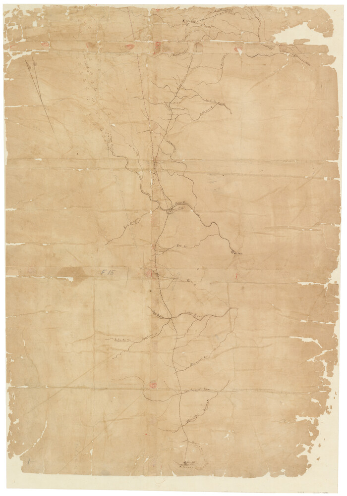
[Surveys along the Trinity River and below]
Print $20.00
- Digital $50.00
[Surveys along the Trinity River and below]
1840
Size: 22.6 x 17.6 inches
101
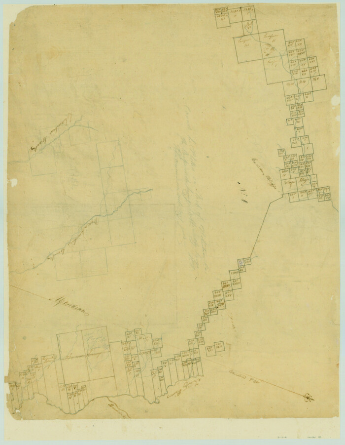
[Surveys along the Nacogdoches River, Richland Creek, and the Trinity River]
Print $20.00
- Digital $50.00
[Surveys along the Nacogdoches River, Richland Creek, and the Trinity River]
1840
Size: 24.2 x 17.9 inches
85
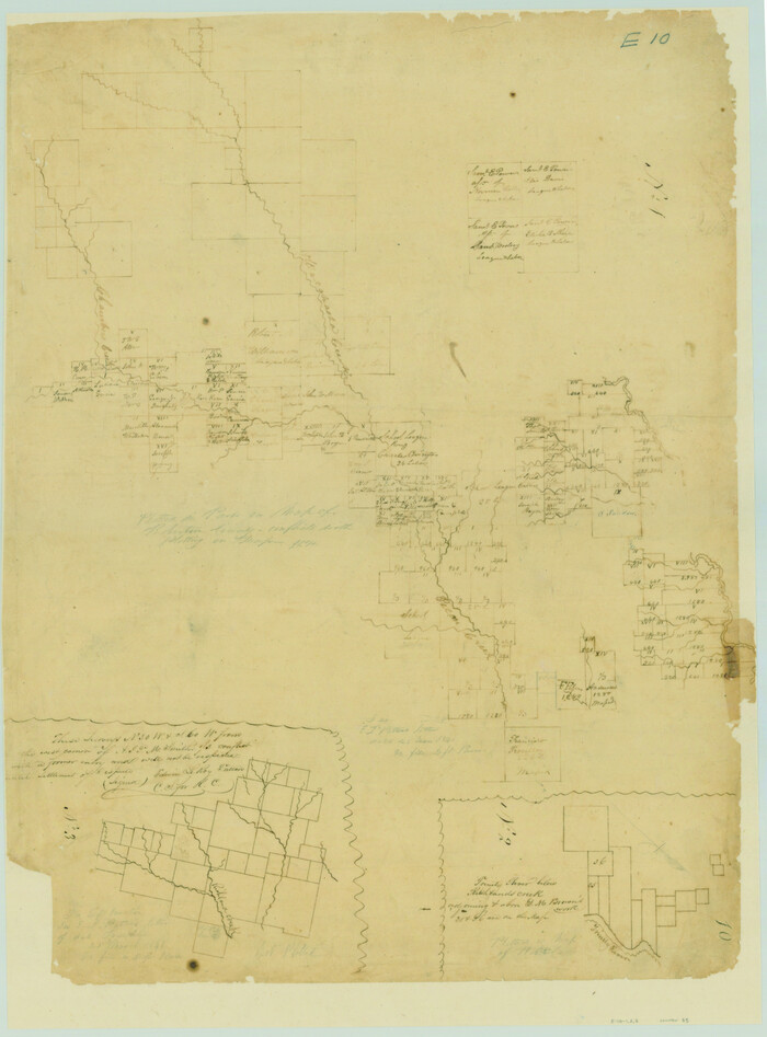
Map of a Part of Robertson Colony

Print $20.00
- Digital $50.00
Map of a Part of Robertson Colony
1843
Size: 32.2 x 22.6 inches
168
[T. J. Chambers' grant]
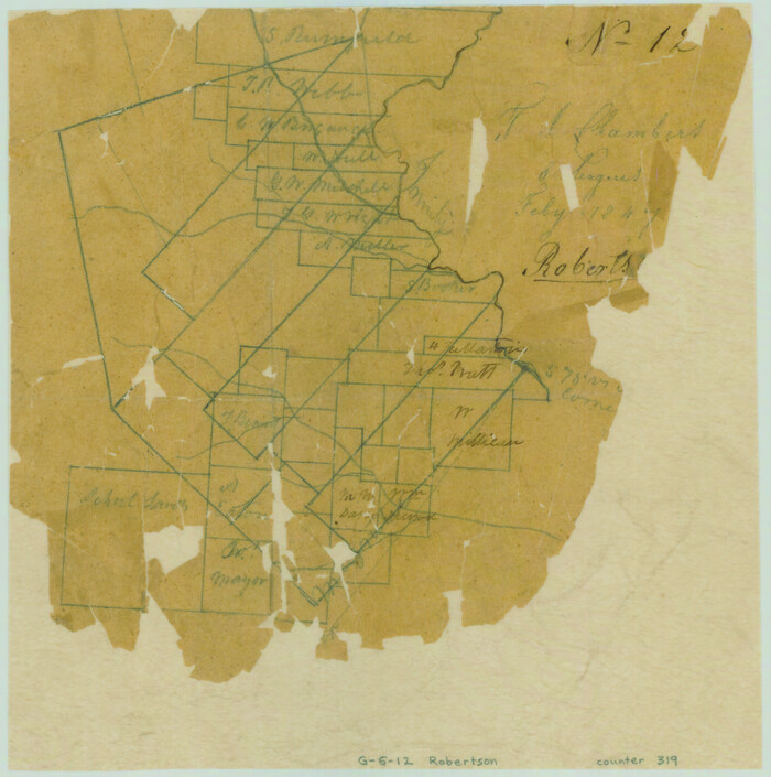
Print $2.00
- Digital $50.00
[T. J. Chambers' grant]
1847
Size: 7.1 x 7.1 inches
319
Ellis County Sketch File 1

Print $6.00
- Digital $50.00
Ellis County Sketch File 1
1849
Size: 6.5 x 7.9 inches
21824
Dallas County Sketch File 19
Print $20.00
- Digital $50.00
Dallas County Sketch File 19
-
Size
17.1 x 17.9 inches
-
Map/Doc
11287
Ellis County Sketch File 3
Print $20.00
- Digital $50.00
Ellis County Sketch File 3
-
Size
23.6 x 28.0 inches
-
Map/Doc
11462
Dallas County Sketch File 19 1/2
Print $4.00
- Digital $50.00
Dallas County Sketch File 19 1/2
-
Size
9.9 x 8.2 inches
-
Map/Doc
20439
Ellis County Sketch File 5
Print $4.00
- Digital $50.00
Ellis County Sketch File 5
-
Size
10.3 x 8.2 inches
-
Map/Doc
21834
Ellis County Sketch File 6
Print $24.00
- Digital $50.00
Ellis County Sketch File 6
-
Size
12.3 x 8.2 inches
-
Map/Doc
21836
Ellis County Sketch File 16
Print $4.00
- Digital $50.00
Ellis County Sketch File 16
-
Size
13.1 x 8.3 inches
-
Map/Doc
21858
Ellis County Sketch File 18
Print $40.00
- Digital $50.00
Ellis County Sketch File 18
-
Size
16.0 x 12.8 inches
-
Map/Doc
21862
Ellis County Sketch File 18a
Print $40.00
- Digital $50.00
Ellis County Sketch File 18a
-
Size
12.8 x 16.0 inches
-
Map/Doc
21864
Hill County Sketch File 25
Print $4.00
- Digital $50.00
Hill County Sketch File 25
-
Size
7.9 x 10.9 inches
-
Map/Doc
26520
Navarro County Sketch File 1
Print $4.00
- Digital $50.00
Navarro County Sketch File 1
-
Size
9.9 x 8.0 inches
-
Map/Doc
32296
Navarro County Sketch File 12
Print $4.00
- Digital $50.00
Navarro County Sketch File 12
-
Size
7.0 x 7.0 inches
-
Map/Doc
32322
Ellis County Boundary File 1
Print $10.00
- Digital $50.00
Ellis County Boundary File 1
-
Size
12.5 x 7.7 inches
-
Map/Doc
52939
Ellis County Boundary File 2
Print $12.00
- Digital $50.00
Ellis County Boundary File 2
-
Size
10.7 x 8.3 inches
-
Map/Doc
52944
Ellis County Boundary File 3
Print $58.00
- Digital $50.00
Ellis County Boundary File 3
-
Size
14.1 x 122.4 inches
-
Map/Doc
52950
Ellis County Boundary File 3a
Print $10.00
- Digital $50.00
Ellis County Boundary File 3a
-
Size
11.2 x 8.9 inches
-
Map/Doc
52960
Ellis County Boundary File 3b
Print $14.00
- Digital $50.00
Ellis County Boundary File 3b
-
Size
11.2 x 8.7 inches
-
Map/Doc
52965
Ellis County Boundary File 3c
Print $130.00
- Digital $50.00
Ellis County Boundary File 3c
-
Size
10.9 x 8.7 inches
-
Map/Doc
52972
Ellis County Boundary File 4
Print $14.00
- Digital $50.00
Ellis County Boundary File 4
-
Size
14.2 x 8.6 inches
-
Map/Doc
52983
Ellis County Boundary File 5
Print $4.00
- Digital $50.00
Ellis County Boundary File 5
-
Size
11.5 x 7.2 inches
-
Map/Doc
52990
Ellis County Boundary File 6
Print $22.00
- Digital $50.00
Ellis County Boundary File 6
-
Size
8.6 x 6.0 inches
-
Map/Doc
52992
Ellis County Boundary File 67 1/2
Print $24.00
- Digital $50.00
Ellis County Boundary File 67 1/2
-
Size
9.0 x 4.1 inches
-
Map/Doc
53003
Map of the Houston & Texas Centr. R.R. from Corsicana, Navarro County, to Dallas, Dallas County
Print $40.00
- Digital $50.00
Map of the Houston & Texas Centr. R.R. from Corsicana, Navarro County, to Dallas, Dallas County
-
Size
27.6 x 88.3 inches
-
Map/Doc
64041
Map of the First Division of the Chicago, Texas & Mexican-Central Railway
Print $40.00
- Digital $50.00
Map of the First Division of the Chicago, Texas & Mexican-Central Railway
-
Size
26.1 x 96.3 inches
-
Map/Doc
64467
Navarro County Working Sketch 1b
Print $20.00
- Digital $50.00
Navarro County Working Sketch 1b
-
Size
32.5 x 44.6 inches
-
Map/Doc
71230
[Sketch of Col. Cooke's Military Road expedition from Red River to Austin]
Print $20.00
- Digital $50.00
[Sketch of Col. Cooke's Military Road expedition from Red River to Austin]
-
Size
33.4 x 23.4 inches
-
Map/Doc
82146
[Surveys along the Trinity River and below]
Print $20.00
- Digital $50.00
[Surveys along the Trinity River and below]
1840
-
Size
22.6 x 17.6 inches
-
Map/Doc
101
-
Creation Date
1840
[Surveys along the Nacogdoches River, Richland Creek, and the Trinity River]
Print $20.00
- Digital $50.00
[Surveys along the Nacogdoches River, Richland Creek, and the Trinity River]
1840
-
Size
24.2 x 17.9 inches
-
Map/Doc
85
-
Creation Date
1840
Map of a Part of Robertson Colony
Print $20.00
- Digital $50.00
Map of a Part of Robertson Colony
1843
-
Size
32.2 x 22.6 inches
-
Map/Doc
168
-
Creation Date
1843
[T. J. Chambers' grant]
Print $2.00
- Digital $50.00
[T. J. Chambers' grant]
1847
-
Size
7.1 x 7.1 inches
-
Map/Doc
319
-
Creation Date
1847
Ellis County Sketch File 1
Print $6.00
- Digital $50.00
Ellis County Sketch File 1
1849
-
Size
6.5 x 7.9 inches
-
Map/Doc
21824
-
Creation Date
1849