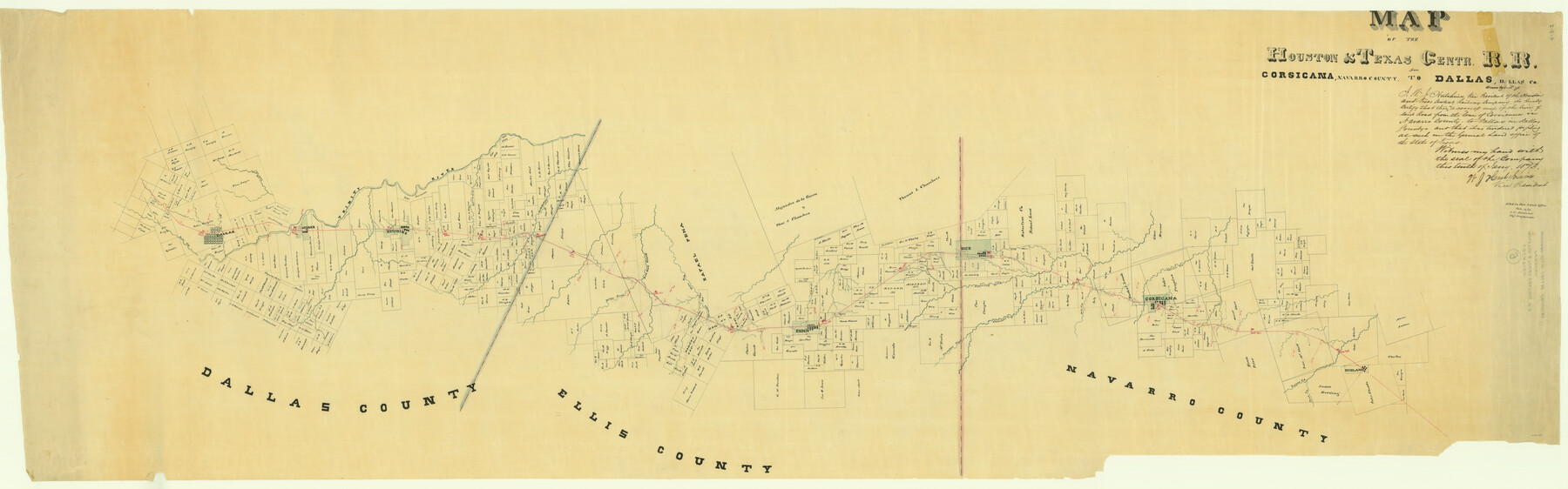
Map of the Houston & Texas Centr. R.R. from Corsicana, Navarro County, to Dallas, Dallas County
Z-2-9
-
Map/Doc
64041
-
Collection
General Map Collection
-
Object Dates
1873/1/13 (File Date)
-
People and Organizations
R. Ross (Draftsman)
C. C. Stremme (Draftsman)
-
Counties
Dallas Navarro Ellis
-
Subjects
Railroads
-
Height x Width
27.6 x 88.3 inches
70.1 x 224.3 cm
-
Medium
linen, manuscript
-
Features
Ennis
Turtle Creek
White Rock Creek
Mill Creek
Dallas
Hutchins
Miller
Trinity River
Brushy Creek
Red Oak Creek
10 Miles Creek
Cottonwood Creek
Grave Creek
Richland
Rice
Cummings Creek
Chambers Creek
Waxahachie Creek
Briar Creek
Schoolhouse Creek
Corsicana
Elm Creek
Pinoak Creek
Richland Creek
H&TC
Part of: General Map Collection
Stonewall County

Print $20.00
- Digital $50.00
Stonewall County
1933
Size 40.3 x 34.5 inches
Map/Doc 77428
Flight Mission No. DCL-4C, Frame 96, Kenedy County

Print $20.00
- Digital $50.00
Flight Mission No. DCL-4C, Frame 96, Kenedy County
1943
Size 18.6 x 22.3 inches
Map/Doc 85817
Jackson County

Print $40.00
- Digital $50.00
Jackson County
1920
Size 48.5 x 40.8 inches
Map/Doc 4989
Harris County Working Sketch 72

Print $20.00
- Digital $50.00
Harris County Working Sketch 72
1958
Size 24.9 x 43.6 inches
Map/Doc 65964
Bexar County Sketch File 33

Print $4.00
- Digital $50.00
Bexar County Sketch File 33
Size 10.7 x 8.5 inches
Map/Doc 14496
Presidio County Rolled Sketch 100

Print $20.00
- Digital $50.00
Presidio County Rolled Sketch 100
1954
Size 30.4 x 30.2 inches
Map/Doc 7382
Deaf Smith County

Print $20.00
- Digital $50.00
Deaf Smith County
1926
Size 32.9 x 41.3 inches
Map/Doc 77260
Andrews County Rolled Sketch 35

Print $20.00
- Digital $50.00
Andrews County Rolled Sketch 35
Size 21.5 x 16.1 inches
Map/Doc 77177
Hartley County Working Sketch Graphic Index

Print $40.00
- Digital $50.00
Hartley County Working Sketch Graphic Index
1925
Size 41.0 x 50.0 inches
Map/Doc 76571
Hudspeth County Rolled Sketch 32

Print $40.00
- Digital $50.00
Hudspeth County Rolled Sketch 32
Size 32.7 x 94.9 inches
Map/Doc 9211
Presidio County Sketch File 5a

Print $4.00
- Digital $50.00
Presidio County Sketch File 5a
1872
Size 12.9 x 8.3 inches
Map/Doc 34435
Bexar County Working Sketch Graphic Index

Print $20.00
- Digital $50.00
Bexar County Working Sketch Graphic Index
1932
Size 47.9 x 42.6 inches
Map/Doc 76466
You may also like
Bell County Sketch File 23a

Print $6.00
- Digital $50.00
Bell County Sketch File 23a
1873
Size 10.0 x 15.7 inches
Map/Doc 14416
[Sketch for Mineral Application 33721 - 33725 Incl. - Padre and Mustang Island]
![2876, [Sketch for Mineral Application 33721 - 33725 Incl. - Padre and Mustang Island], General Map Collection](https://historictexasmaps.com/wmedia_w700/maps/2876.tif.jpg)
Print $20.00
- Digital $50.00
[Sketch for Mineral Application 33721 - 33725 Incl. - Padre and Mustang Island]
1942
Size 29.1 x 23.0 inches
Map/Doc 2876
General Highway Map, Cass County, Texas

Print $20.00
General Highway Map, Cass County, Texas
1940
Size 18.6 x 25.2 inches
Map/Doc 79042
Map of Terry County

Print $20.00
- Digital $50.00
Map of Terry County
1902
Size 45.6 x 40.8 inches
Map/Doc 16893
Oldham County Sketch File 13

Print $40.00
- Digital $50.00
Oldham County Sketch File 13
1902
Size 14.3 x 12.3 inches
Map/Doc 33260
Angelina County Working Sketch 48

Print $20.00
- Digital $50.00
Angelina County Working Sketch 48
1980
Size 33.5 x 38.9 inches
Map/Doc 67131
St. Louis, Brownsville & Mexico Railway Location Map from Mile 20 to Mile 40

Print $40.00
- Digital $50.00
St. Louis, Brownsville & Mexico Railway Location Map from Mile 20 to Mile 40
1906
Size 19.3 x 67.5 inches
Map/Doc 64077
Donley County Working Sketch 6

Print $20.00
- Digital $50.00
Donley County Working Sketch 6
1965
Size 34.3 x 42.2 inches
Map/Doc 68739
El Paso County Rolled Sketch 31

Print $20.00
- Digital $50.00
El Paso County Rolled Sketch 31
1908
Size 39.9 x 32.0 inches
Map/Doc 8858
Flight Mission No. CRC-3R, Frame 166, Chambers County

Print $20.00
- Digital $50.00
Flight Mission No. CRC-3R, Frame 166, Chambers County
1956
Size 18.8 x 22.4 inches
Map/Doc 84848
Titus County Sketch File 1

Print $4.00
- Digital $50.00
Titus County Sketch File 1
Size 13.3 x 8.2 inches
Map/Doc 38130
[Sketch for Mineral Application 16700 - Pecos River Bed]
![2807, [Sketch for Mineral Application 16700 - Pecos River Bed], General Map Collection](https://historictexasmaps.com/wmedia_w700/maps/2807.tif.jpg)
Print $20.00
- Digital $50.00
[Sketch for Mineral Application 16700 - Pecos River Bed]
1927
Size 32.9 x 15.3 inches
Map/Doc 2807