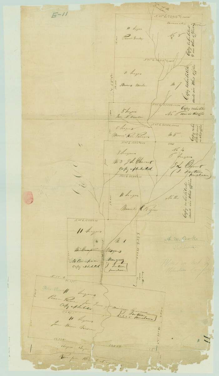
[Titles along the Trinity River]
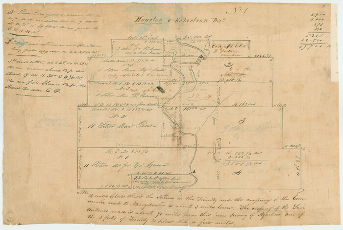
Print $3.00
- Digital $50.00
[Titles along the Trinity River]
Size: 10.6 x 15.8 inches
175
[Surveys between Big Keechi Creek and the Trinity River]
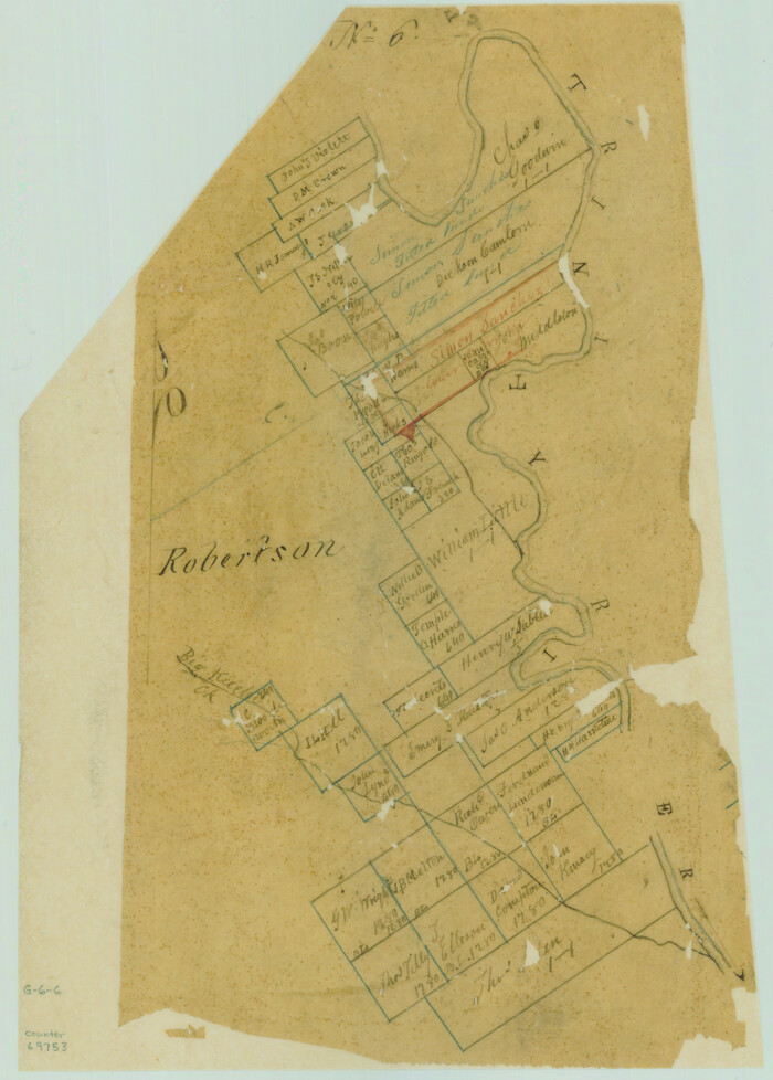
Print $2.00
- Digital $50.00
[Surveys between Big Keechi Creek and the Trinity River]
Size: 10.1 x 7.3 inches
69753
[Surveys along the Sabine River made under G.W. Smyth, Commissioner]
Print $20.00
- Digital $50.00
[Surveys along the Sabine River made under G.W. Smyth, Commissioner]
Size: 12.6 x 17.1 inches
89
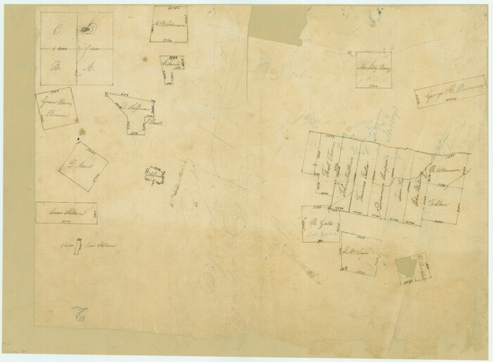
[Surveys along Tehuacano and Grindstone Creek, drawings X and Y]
Print $20.00
- Digital $50.00
[Surveys along Tehuacano and Grindstone Creek, drawings X and Y]
1846
Size: 12.4 x 18.3 inches
299
[Large surveys along the Navasota River]
Print $20.00
- Digital $50.00
[Large surveys along the Navasota River]
1840
Size: 24.5 x 14.3 inches
48
Trinity River, Wildcat Ferry Sheet

Print $20.00
- Digital $50.00
Trinity River, Wildcat Ferry Sheet
1928
Size: 41.5 x 40.9 inches
65182
Trinity River, Walker's Lake Sheet/Richland Creek

Print $20.00
- Digital $50.00
Trinity River, Walker's Lake Sheet/Richland Creek
1931
Size: 25.9 x 41.2 inches
65226
Trinity River, Levee Improvement Districts Widths of Floodways

Print $6.00
- Digital $50.00
Trinity River, Levee Improvement Districts Widths of Floodways
1920
Size: 33.9 x 23.0 inches
65249
Trinity River, Levee Improvement Districts Widths of Floodways

Print $6.00
- Digital $50.00
Trinity River, Levee Improvement Districts Widths of Floodways
1920
Size: 33.3 x 21.7 inches
65251
Trinity River, Cox Bluff Sheet

Print $20.00
- Digital $50.00
Trinity River, Cox Bluff Sheet
1926
Size: 36.0 x 46.2 inches
65214
Trinity River, Cooks Ferry Sheet

Print $40.00
- Digital $50.00
Trinity River, Cooks Ferry Sheet
1926
Size: 36.5 x 56.2 inches
65215
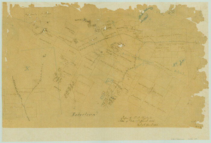
Sketch of Robertson Co., Tehuacana Creek

Print $3.00
- Digital $50.00
Sketch of Robertson Co., Tehuacana Creek
1846
Size: 10.3 x 16.4 inches
264
Sketch Richland Creek, Robertson Co.

Print $2.00
- Digital $50.00
Sketch Richland Creek, Robertson Co.
Size: 10.4 x 7.9 inches
266
Navarro County Working Sketch 14

Print $20.00
- Digital $50.00
Navarro County Working Sketch 14
1981
Size: 36.8 x 33.1 inches
71244
Navarro County Sketch File 18

Print $3.00
- Digital $50.00
Navarro County Sketch File 18
1871
Size: 10.6 x 10.0 inches
32335
Navarro County Sketch File 13

Print $22.00
- Digital $50.00
Navarro County Sketch File 13
Size: 12.0 x 8.6 inches
32324
Map of the Line of the H. & Texas Cen. Railway from the Navasota River, 72 1/2 Miles from Houston, to Corsicana in Navarro Co., 211 mls from Houston

Print $40.00
- Digital $50.00
Map of the Line of the H. & Texas Cen. Railway from the Navasota River, 72 1/2 Miles from Houston, to Corsicana in Navarro Co., 211 mls from Houston
Size: 39.2 x 61.4 inches
64086
Map of Freestone County

Print $20.00
- Digital $50.00
Map of Freestone County
1888
Size: 27.0 x 22.3 inches
3561
Map of Freestone County

Print $20.00
- Digital $50.00
Map of Freestone County
1874
Size: 21.8 x 24.5 inches
3563
Map of Freestone County

Print $20.00
- Digital $50.00
Map of Freestone County
1858
Size: 22.3 x 24.1 inches
3564
Limestone County Working Sketch 4

Print $20.00
- Digital $50.00
Limestone County Working Sketch 4
1921
Size: 20.2 x 26.3 inches
70554
Limestone County Working Sketch 23

Print $20.00
- Digital $50.00
Limestone County Working Sketch 23
1980
Size: 37.3 x 37.5 inches
70573
Limestone County Working Sketch 22

Print $40.00
- Digital $50.00
Limestone County Working Sketch 22
1980
Size: 43.3 x 60.2 inches
70572
Limestone County Sketch File A

Print $40.00
- Digital $50.00
Limestone County Sketch File A
1833
Size: 15.7 x 12.8 inches
30149
Limestone County Sketch File 3

Print $4.00
- Digital $50.00
Limestone County Sketch File 3
1850
Size: 7.9 x 10.7 inches
30158
Limestone County Sketch File 10

Print $4.00
- Digital $50.00
Limestone County Sketch File 10
Size: 8.4 x 9.4 inches
30171
Leon County Working Sketch 46

Print $20.00
- Digital $50.00
Leon County Working Sketch 46
1980
Size: 41.5 x 27.1 inches
70445
Leon County Working Sketch 45

Print $20.00
- Digital $50.00
Leon County Working Sketch 45
1980
Size: 45.4 x 37.4 inches
70444
Leon County Working Sketch 44

Print $40.00
- Digital $50.00
Leon County Working Sketch 44
1980
Size: 42.8 x 59.8 inches
70443
Leon County Working Sketch 43

Print $40.00
- Digital $50.00
Leon County Working Sketch 43
1980
Size: 55.1 x 38.0 inches
70442
[Titles along the Trinity River]
Print $3.00
- Digital $50.00
[Titles along the Trinity River]
-
Size
10.6 x 15.8 inches
-
Map/Doc
175
[Surveys between Big Keechi Creek and the Trinity River]
Print $2.00
- Digital $50.00
[Surveys between Big Keechi Creek and the Trinity River]
-
Size
10.1 x 7.3 inches
-
Map/Doc
69753
[Surveys along the Sabine River made under G.W. Smyth, Commissioner]
Print $20.00
- Digital $50.00
[Surveys along the Sabine River made under G.W. Smyth, Commissioner]
-
Size
12.6 x 17.1 inches
-
Map/Doc
89
[Surveys along Tehuacano and Grindstone Creek, drawings X and Y]
Print $20.00
- Digital $50.00
[Surveys along Tehuacano and Grindstone Creek, drawings X and Y]
1846
-
Size
12.4 x 18.3 inches
-
Map/Doc
299
-
Creation Date
1846
[Large surveys along the Navasota River]
Print $20.00
- Digital $50.00
[Large surveys along the Navasota River]
1840
-
Size
24.5 x 14.3 inches
-
Map/Doc
48
-
Creation Date
1840
Trinity River, Wildcat Ferry Sheet
Print $20.00
- Digital $50.00
Trinity River, Wildcat Ferry Sheet
1928
-
Size
41.5 x 40.9 inches
-
Map/Doc
65182
-
Creation Date
1928
Trinity River, Walker's Lake Sheet/Richland Creek
Print $20.00
- Digital $50.00
Trinity River, Walker's Lake Sheet/Richland Creek
1931
-
Size
25.9 x 41.2 inches
-
Map/Doc
65226
-
Creation Date
1931
Trinity River, Levee Improvement Districts Widths of Floodways
Print $6.00
- Digital $50.00
Trinity River, Levee Improvement Districts Widths of Floodways
1920
-
Size
33.9 x 23.0 inches
-
Map/Doc
65249
-
Creation Date
1920
Trinity River, Levee Improvement Districts Widths of Floodways
Print $6.00
- Digital $50.00
Trinity River, Levee Improvement Districts Widths of Floodways
1920
-
Size
33.3 x 21.7 inches
-
Map/Doc
65251
-
Creation Date
1920
Trinity River, Cox Bluff Sheet
Print $20.00
- Digital $50.00
Trinity River, Cox Bluff Sheet
1926
-
Size
36.0 x 46.2 inches
-
Map/Doc
65214
-
Creation Date
1926
Trinity River, Cooks Ferry Sheet
Print $40.00
- Digital $50.00
Trinity River, Cooks Ferry Sheet
1926
-
Size
36.5 x 56.2 inches
-
Map/Doc
65215
-
Creation Date
1926
Sketch of Robertson Co., Tehuacana Creek
Print $3.00
- Digital $50.00
Sketch of Robertson Co., Tehuacana Creek
1846
-
Size
10.3 x 16.4 inches
-
Map/Doc
264
-
Creation Date
1846
Sketch Richland Creek, Robertson Co.
Print $2.00
- Digital $50.00
Sketch Richland Creek, Robertson Co.
-
Size
10.4 x 7.9 inches
-
Map/Doc
266
Navarro County Working Sketch 14
Print $20.00
- Digital $50.00
Navarro County Working Sketch 14
1981
-
Size
36.8 x 33.1 inches
-
Map/Doc
71244
-
Creation Date
1981
Navarro County Sketch File 18
Print $3.00
- Digital $50.00
Navarro County Sketch File 18
1871
-
Size
10.6 x 10.0 inches
-
Map/Doc
32335
-
Creation Date
1871
Navarro County Sketch File 13
Print $22.00
- Digital $50.00
Navarro County Sketch File 13
-
Size
12.0 x 8.6 inches
-
Map/Doc
32324
Map of the Line of the H. & Texas Cen. Railway from the Navasota River, 72 1/2 Miles from Houston, to Corsicana in Navarro Co., 211 mls from Houston
Print $40.00
- Digital $50.00
Map of the Line of the H. & Texas Cen. Railway from the Navasota River, 72 1/2 Miles from Houston, to Corsicana in Navarro Co., 211 mls from Houston
-
Size
39.2 x 61.4 inches
-
Map/Doc
64086
Map of Freestone County
Print $20.00
- Digital $50.00
Map of Freestone County
1888
-
Size
27.0 x 22.3 inches
-
Map/Doc
3561
-
Creation Date
1888
Map of Freestone County
Print $20.00
- Digital $50.00
Map of Freestone County
1874
-
Size
21.8 x 24.5 inches
-
Map/Doc
3563
-
Creation Date
1874
Map of Freestone County
Print $20.00
- Digital $50.00
Map of Freestone County
1858
-
Size
22.3 x 24.1 inches
-
Map/Doc
3564
-
Creation Date
1858
Limestone County Working Sketch 4
Print $20.00
- Digital $50.00
Limestone County Working Sketch 4
1921
-
Size
20.2 x 26.3 inches
-
Map/Doc
70554
-
Creation Date
1921
Limestone County Working Sketch 23
Print $20.00
- Digital $50.00
Limestone County Working Sketch 23
1980
-
Size
37.3 x 37.5 inches
-
Map/Doc
70573
-
Creation Date
1980
Limestone County Working Sketch 22
Print $40.00
- Digital $50.00
Limestone County Working Sketch 22
1980
-
Size
43.3 x 60.2 inches
-
Map/Doc
70572
-
Creation Date
1980
Limestone County Sketch File A
Print $40.00
- Digital $50.00
Limestone County Sketch File A
1833
-
Size
15.7 x 12.8 inches
-
Map/Doc
30149
-
Creation Date
1833
Limestone County Sketch File 3
Print $4.00
- Digital $50.00
Limestone County Sketch File 3
1850
-
Size
7.9 x 10.7 inches
-
Map/Doc
30158
-
Creation Date
1850
Limestone County Sketch File 10
Print $4.00
- Digital $50.00
Limestone County Sketch File 10
-
Size
8.4 x 9.4 inches
-
Map/Doc
30171
Leon County Working Sketch 46
Print $20.00
- Digital $50.00
Leon County Working Sketch 46
1980
-
Size
41.5 x 27.1 inches
-
Map/Doc
70445
-
Creation Date
1980
Leon County Working Sketch 45
Print $20.00
- Digital $50.00
Leon County Working Sketch 45
1980
-
Size
45.4 x 37.4 inches
-
Map/Doc
70444
-
Creation Date
1980
Leon County Working Sketch 44
Print $40.00
- Digital $50.00
Leon County Working Sketch 44
1980
-
Size
42.8 x 59.8 inches
-
Map/Doc
70443
-
Creation Date
1980
Leon County Working Sketch 43
Print $40.00
- Digital $50.00
Leon County Working Sketch 43
1980
-
Size
55.1 x 38.0 inches
-
Map/Doc
70442
-
Creation Date
1980