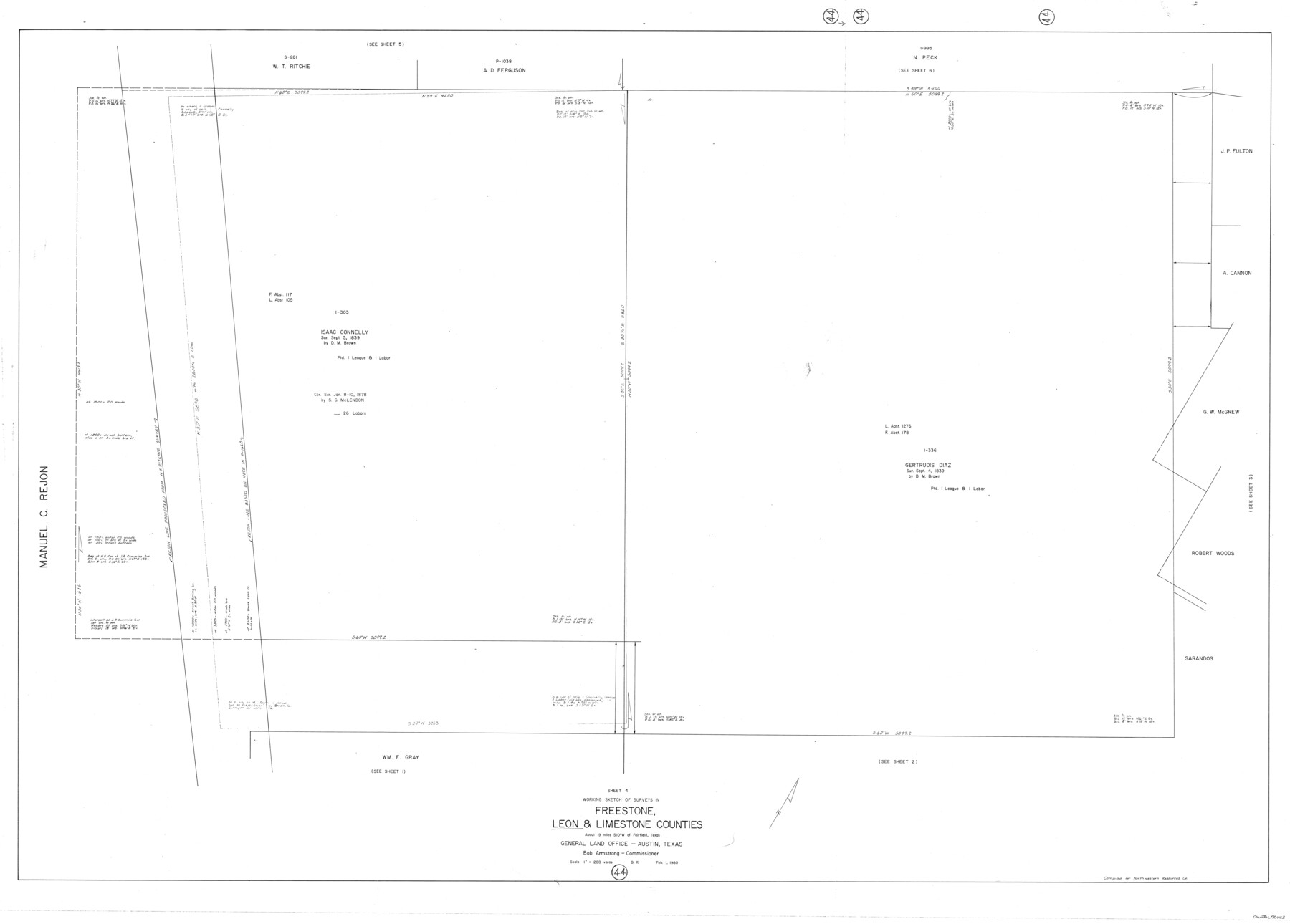
Leon County Working Sketch 44
-
Map/Doc
70443
-
Collection
General Map Collection
-
Object Dates
2/1/1980 (Creation Date)
-
People and Organizations
Beverly Robison (Draftsman)
-
Counties
Leon Freestone Limestone
-
Subjects
Surveying Working Sketch
-
Height x Width
42.8 x 59.8 inches
108.7 x 151.9 cm
-
Scale
1" = 200 varas
Part of: General Map Collection
Sutton County Rolled Sketch 62

Print $40.00
- Digital $50.00
Sutton County Rolled Sketch 62
Size 69.8 x 45.2 inches
Map/Doc 9978
Flight Mission No. DCL-7C, Frame 134, Kenedy County

Print $20.00
- Digital $50.00
Flight Mission No. DCL-7C, Frame 134, Kenedy County
1943
Size 18.5 x 22.3 inches
Map/Doc 86091
Burnet County Rolled Sketch 7

Print $20.00
- Digital $50.00
Burnet County Rolled Sketch 7
1987
Size 18.4 x 24.0 inches
Map/Doc 5357
Hudspeth County Working Sketch 21

Print $20.00
- Digital $50.00
Hudspeth County Working Sketch 21
1966
Size 22.8 x 41.6 inches
Map/Doc 66303
Gulf Intracoastal Waterway, Tex. - Aransas Bay to Corpus Christi Bay - Modified Route of Main Channel/Dredging

Print $20.00
- Digital $50.00
Gulf Intracoastal Waterway, Tex. - Aransas Bay to Corpus Christi Bay - Modified Route of Main Channel/Dredging
1958
Size 30.8 x 42.8 inches
Map/Doc 61896

Washington County Sketch File 5

Print $4.00
- Digital $50.00
Washington County Sketch File 5
Size 8.0 x 7.0 inches
Map/Doc 39652
Erath County Working Sketch 16

Print $20.00
- Digital $50.00
Erath County Working Sketch 16
1961
Size 20.9 x 26.5 inches
Map/Doc 69097
Austin County Boundary File 3

Print $2.00
- Digital $50.00
Austin County Boundary File 3
Size 14.3 x 8.6 inches
Map/Doc 50243
Navarro County Sketch File 7

Print $4.00
- Digital $50.00
Navarro County Sketch File 7
1854
Size 12.2 x 8.0 inches
Map/Doc 32313
El Paso County Rolled Sketch 52

Print $20.00
- Digital $50.00
El Paso County Rolled Sketch 52
1929
Size 18.5 x 24.3 inches
Map/Doc 5849
Zapata County Working Sketch 3

Print $20.00
- Digital $50.00
Zapata County Working Sketch 3
1932
Size 18.0 x 13.6 inches
Map/Doc 62054
You may also like

Map of Titus County

Print $20.00
- Digital $50.00
Map of Titus County
1857
Size 24.1 x 34.5 inches
Map/Doc 83380
Palo Pinto County Working Sketch 26

Print $20.00
- Digital $50.00
Palo Pinto County Working Sketch 26
1993
Map/Doc 71409
Menard County

Print $20.00
- Digital $50.00
Menard County
1942
Size 40.1 x 43.7 inches
Map/Doc 66928
Newton County Working Sketch 38

Print $20.00
- Digital $50.00
Newton County Working Sketch 38
1961
Size 36.8 x 29.2 inches
Map/Doc 71284
Galveston County NRC Article 33.136 Sketch 95

Print $40.00
Galveston County NRC Article 33.136 Sketch 95
2024
Map/Doc 97368
[Blocks W, A4, A2, T, D10, B, JD, O, JK4]
![92251, [Blocks W, A4, A2, T, D10, B, JD, O, JK4], Twichell Survey Records](https://historictexasmaps.com/wmedia_w700/maps/92251-1.tif.jpg)
Print $20.00
- Digital $50.00
[Blocks W, A4, A2, T, D10, B, JD, O, JK4]
Size 36.9 x 30.1 inches
Map/Doc 92251
Dallas County Sketch File 15

Print $10.00
- Digital $50.00
Dallas County Sketch File 15
1863
Size 11.5 x 8.5 inches
Map/Doc 20430
Bexar County Sketch File 3

Print $4.00
- Digital $50.00
Bexar County Sketch File 3
Size 12.8 x 8.3 inches
Map/Doc 14473
General Highway Map. Detail of Cities and Towns in Travis County, Texas

Print $20.00
General Highway Map. Detail of Cities and Towns in Travis County, Texas
1961
Size 18.1 x 24.7 inches
Map/Doc 79683
Medina County Rolled Sketch 8

Print $20.00
- Digital $50.00
Medina County Rolled Sketch 8
1975
Size 24.8 x 25.5 inches
Map/Doc 6742
Flight Mission No. BRA-7M, Frame 195, Jefferson County

Print $20.00
- Digital $50.00
Flight Mission No. BRA-7M, Frame 195, Jefferson County
1953
Size 18.5 x 22.4 inches
Map/Doc 85563