[Young Territory]

Print $40.00
- Digital $50.00
[Young Territory]
1875
Size: 49.0 x 87.4 inches
16784
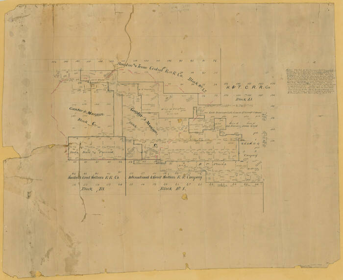
[Surveying Sketch of Houston and Texas Central R. R. Co., Gunter & Munson, Houston & Great Northern R. R. Co., International & Great Northern R. R. Company, et al]
Print $20.00
- Digital $50.00
[Surveying Sketch of Houston and Texas Central R. R. Co., Gunter & Munson, Houston & Great Northern R. R. Co., International & Great Northern R. R. Company, et al]
Size: 23.1 x 28.3 inches
75763
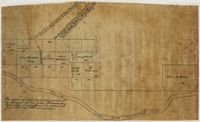
[Sketch of surveys north of Canadian River, Hemphill County, Texas]
Print $3.00
- Digital $50.00
[Sketch of surveys north of Canadian River, Hemphill County, Texas]
1882
Size: 10.5 x 13.5 inches
484
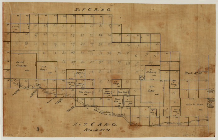
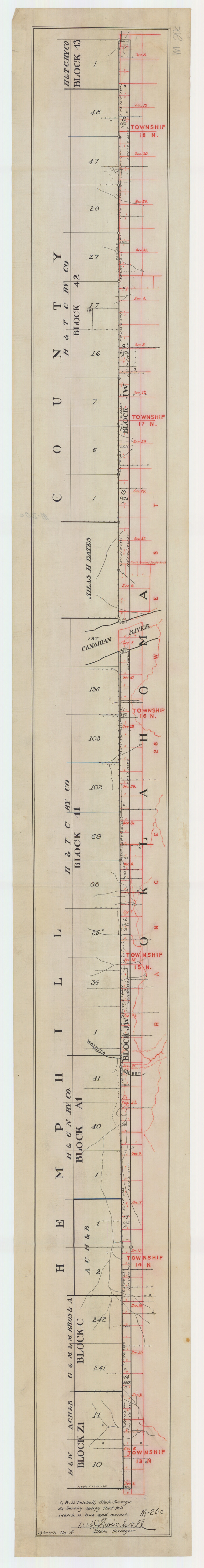
[Sketch of H & T C RR Co. Blocks north of the Canadian River, Hemphill County, Texas]
Print $3.00
- Digital $50.00
[Sketch of H & T C RR Co. Blocks north of the Canadian River, Hemphill County, Texas]
Size: 10.4 x 16.1 inches
10758
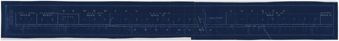
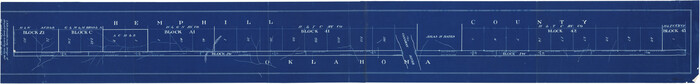
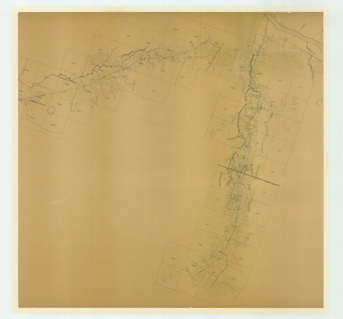
[Sketch between Hemphill County and Oklahoma]
Print $40.00
- Digital $50.00
[Sketch between Hemphill County and Oklahoma]
Size: 65.2 x 9.5 inches
89672
[Sketch Showing Surveys north of South Canadian River, Hemphill County, Texas]
Print $3.00
- Digital $50.00
[Sketch Showing Surveys north of South Canadian River, Hemphill County, Texas]
Size: 9.8 x 14.9 inches
10759
[Sketch Between Hemphill County and Oklahoma]
Print $40.00
- Digital $50.00
[Sketch Between Hemphill County and Oklahoma]
Size: 62.0 x 8.0 inches
89635
[Sketch Between Hemphill County and Oklahoma]
Print $40.00
- Digital $50.00
[Sketch Between Hemphill County and Oklahoma]
Size: 8.1 x 62.5 inches
89664
[Sketch Between Hemphill County and Oklahoma]
Print $40.00
- Digital $50.00
[Sketch Between Hemphill County and Oklahoma]
Size: 60.4 x 7.8 inches
89670
[Location Survey of the Southern Kansas Railway, Kiowa Extension from a point in Drake's Location, in Indian Territory 100 miles from south line of Kansas, continuing up Wolf Creek and South Canadian River to Cottonwood Creek in Hutchinson County]
Print $20.00
- Digital $50.00
[Location Survey of the Southern Kansas Railway, Kiowa Extension from a point in Drake's Location, in Indian Territory 100 miles from south line of Kansas, continuing up Wolf Creek and South Canadian River to Cottonwood Creek in Hutchinson County]
1886
Size: 39.1 x 42.0 inches
88841
[Location Survey of the Southern Kansas Railway, Kiowa Extension from a point in Drake's Location, in Indian Territory 100 miles from south line of Kansas, continuing up Wolf Creek and South Canadian River to Cottonwood Creek in Hutchinson County]
Print $20.00
- Digital $50.00
[Location Survey of the Southern Kansas Railway, Kiowa Extension from a point in Drake's Location, in Indian Territory 100 miles from south line of Kansas, continuing up Wolf Creek and South Canadian River to Cottonwood Creek in Hutchinson County]
1886
Size: 39.0 x 42.0 inches
88842
[East Line, Hemphill County]
Print $2.00
- Digital $50.00
[East Line, Hemphill County]
Size: 5.4 x 15.0 inches
90725
Working Sketch in Wheeler County

Print $20.00
- Digital $50.00
Working Sketch in Wheeler County
1910
Size: 7.0 x 39.5 inches
90731
Working Sketch in Collingsworth County

Print $20.00
- Digital $50.00
Working Sketch in Collingsworth County
1910
Size: 6.5 x 38.9 inches
90728
Working Sketch Hemphill County

Print $20.00
- Digital $50.00
Working Sketch Hemphill County
1910
Size: 38.3 x 6.6 inches
90673
Working Sketch Hemphill County

Print $20.00
- Digital $50.00
Working Sketch Hemphill County
1910
Size: 6.9 x 39.1 inches
90730
Working Sketch in Lipscomb County

Print $20.00
- Digital $50.00
Working Sketch in Lipscomb County
1910
Size: 6.8 x 39.1 inches
90732
Wheeler County Working Sketch 12

Print $40.00
- Digital $50.00
Wheeler County Working Sketch 12
1978
Size: 38.5 x 51.1 inches
72501
Wheeler County Sketch File 1

Print $20.00
- Digital $50.00
Wheeler County Sketch File 1
Size: 17.1 x 26.8 inches
12672
Thomas Ross Survey

Print $20.00
- Digital $50.00
Thomas Ross Survey
1954
Size: 16.8 x 17.6 inches
92181
Texas Panhandle East Boundary Line

Print $40.00
- Digital $50.00
Texas Panhandle East Boundary Line
1898
Size: 9.2 x 64.9 inches
1716
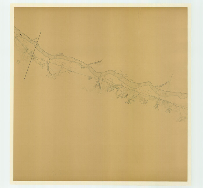
Roberts County Working Sketch 22

Print $20.00
- Digital $50.00
Roberts County Working Sketch 22
1978
Size: 31.0 x 42.9 inches
63548
Roberts County Working Sketch 12

Print $20.00
- Digital $50.00
Roberts County Working Sketch 12
Size: 25.5 x 22.5 inches
63538
North Half, Harris County, Texas - Ownership Map with Well Data

North Half, Harris County, Texas - Ownership Map with Well Data
1948
Size: 121.9 x 44.3 inches
93206
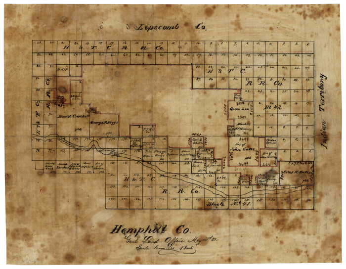
Map of Hemphill County

Print $20.00
- Digital $50.00
Map of Hemphill County
1899
Size: 41.2 x 38.5 inches
95527
Location of the Southern Kansas Railway of Texas through Hemphill County, Texas

Print $40.00
- Digital $50.00
Location of the Southern Kansas Railway of Texas through Hemphill County, Texas
1887
Size: 20.2 x 91.8 inches
64000
Location Survey of the Southern Kansas Railway, Kiowa Extension from a point in Drake's Location, in Indian Territory 100 miles from south line of Kansas, continuing up Wolf Creek and South Canadian River to Cottonwood Creek in Hutchinson County

Print $40.00
- Digital $50.00
Location Survey of the Southern Kansas Railway, Kiowa Extension from a point in Drake's Location, in Indian Territory 100 miles from south line of Kansas, continuing up Wolf Creek and South Canadian River to Cottonwood Creek in Hutchinson County
1886
Size: 37.5 x 282.7 inches
88837
Lipscomb County Sketch File 4

Print $56.00
- Digital $50.00
Lipscomb County Sketch File 4
1910
Size: 11.2 x 8.7 inches
30233
Lipscomb County Rolled Sketch 5

Print $40.00
- Digital $50.00
Lipscomb County Rolled Sketch 5
Size: 60.5 x 8.0 inches
81427
Hemphill County, Texas

Print $20.00
- Digital $50.00
Hemphill County, Texas
1880
Size: 19.7 x 18.6 inches
549
[Young Territory]
Print $40.00
- Digital $50.00
[Young Territory]
1875
-
Size
49.0 x 87.4 inches
-
Map/Doc
16784
-
Creation Date
1875
[Surveying Sketch of Houston and Texas Central R. R. Co., Gunter & Munson, Houston & Great Northern R. R. Co., International & Great Northern R. R. Company, et al]
Print $20.00
- Digital $50.00
[Surveying Sketch of Houston and Texas Central R. R. Co., Gunter & Munson, Houston & Great Northern R. R. Co., International & Great Northern R. R. Company, et al]
-
Size
23.1 x 28.3 inches
-
Map/Doc
75763
[Sketch of surveys north of Canadian River, Hemphill County, Texas]
Print $3.00
- Digital $50.00
[Sketch of surveys north of Canadian River, Hemphill County, Texas]
1882
-
Size
10.5 x 13.5 inches
-
Map/Doc
484
-
Creation Date
1882
[Sketch of H & T C RR Co. Blocks north of the Canadian River, Hemphill County, Texas]
Print $3.00
- Digital $50.00
[Sketch of H & T C RR Co. Blocks north of the Canadian River, Hemphill County, Texas]
-
Size
10.4 x 16.1 inches
-
Map/Doc
10758
[Sketch between Hemphill County and Oklahoma]
Print $40.00
- Digital $50.00
[Sketch between Hemphill County and Oklahoma]
-
Size
65.2 x 9.5 inches
-
Map/Doc
89672
[Sketch Showing Surveys north of South Canadian River, Hemphill County, Texas]
Print $3.00
- Digital $50.00
[Sketch Showing Surveys north of South Canadian River, Hemphill County, Texas]
-
Size
9.8 x 14.9 inches
-
Map/Doc
10759
[Sketch Between Hemphill County and Oklahoma]
Print $40.00
- Digital $50.00
[Sketch Between Hemphill County and Oklahoma]
-
Size
62.0 x 8.0 inches
-
Map/Doc
89635
[Sketch Between Hemphill County and Oklahoma]
Print $40.00
- Digital $50.00
[Sketch Between Hemphill County and Oklahoma]
-
Size
8.1 x 62.5 inches
-
Map/Doc
89664
[Sketch Between Hemphill County and Oklahoma]
Print $40.00
- Digital $50.00
[Sketch Between Hemphill County and Oklahoma]
-
Size
60.4 x 7.8 inches
-
Map/Doc
89670
[Location Survey of the Southern Kansas Railway, Kiowa Extension from a point in Drake's Location, in Indian Territory 100 miles from south line of Kansas, continuing up Wolf Creek and South Canadian River to Cottonwood Creek in Hutchinson County]
Print $20.00
- Digital $50.00
[Location Survey of the Southern Kansas Railway, Kiowa Extension from a point in Drake's Location, in Indian Territory 100 miles from south line of Kansas, continuing up Wolf Creek and South Canadian River to Cottonwood Creek in Hutchinson County]
1886
-
Size
39.1 x 42.0 inches
-
Map/Doc
88841
-
Creation Date
1886
[Location Survey of the Southern Kansas Railway, Kiowa Extension from a point in Drake's Location, in Indian Territory 100 miles from south line of Kansas, continuing up Wolf Creek and South Canadian River to Cottonwood Creek in Hutchinson County]
Print $20.00
- Digital $50.00
[Location Survey of the Southern Kansas Railway, Kiowa Extension from a point in Drake's Location, in Indian Territory 100 miles from south line of Kansas, continuing up Wolf Creek and South Canadian River to Cottonwood Creek in Hutchinson County]
1886
-
Size
39.0 x 42.0 inches
-
Map/Doc
88842
-
Creation Date
1886
[East Line, Hemphill County]
Print $2.00
- Digital $50.00
[East Line, Hemphill County]
-
Size
5.4 x 15.0 inches
-
Map/Doc
90725
Working Sketch in Wheeler County
Print $20.00
- Digital $50.00
Working Sketch in Wheeler County
1910
-
Size
7.0 x 39.5 inches
-
Map/Doc
90731
-
Creation Date
1910
Working Sketch in Collingsworth County
Print $20.00
- Digital $50.00
Working Sketch in Collingsworth County
1910
-
Size
6.5 x 38.9 inches
-
Map/Doc
90728
-
Creation Date
1910
Working Sketch Hemphill County
Print $20.00
- Digital $50.00
Working Sketch Hemphill County
1910
-
Size
38.3 x 6.6 inches
-
Map/Doc
90673
-
Creation Date
1910
Working Sketch Hemphill County
Print $20.00
- Digital $50.00
Working Sketch Hemphill County
1910
-
Size
6.9 x 39.1 inches
-
Map/Doc
90730
-
Creation Date
1910
Working Sketch in Lipscomb County
Print $20.00
- Digital $50.00
Working Sketch in Lipscomb County
1910
-
Size
6.8 x 39.1 inches
-
Map/Doc
90732
-
Creation Date
1910
Wheeler County Working Sketch 12
Print $40.00
- Digital $50.00
Wheeler County Working Sketch 12
1978
-
Size
38.5 x 51.1 inches
-
Map/Doc
72501
-
Creation Date
1978
Wheeler County Sketch File 1
Print $20.00
- Digital $50.00
Wheeler County Sketch File 1
-
Size
17.1 x 26.8 inches
-
Map/Doc
12672
Thomas Ross Survey
Print $20.00
- Digital $50.00
Thomas Ross Survey
1954
-
Size
16.8 x 17.6 inches
-
Map/Doc
92181
-
Creation Date
1954
Texas Panhandle East Boundary Line
Print $40.00
- Digital $50.00
Texas Panhandle East Boundary Line
1898
-
Size
9.2 x 64.9 inches
-
Map/Doc
1716
-
Creation Date
1898
Roberts County Working Sketch 22
Print $20.00
- Digital $50.00
Roberts County Working Sketch 22
1978
-
Size
31.0 x 42.9 inches
-
Map/Doc
63548
-
Creation Date
1978
Roberts County Working Sketch 12
Print $20.00
- Digital $50.00
Roberts County Working Sketch 12
-
Size
25.5 x 22.5 inches
-
Map/Doc
63538
North Half, Harris County, Texas - Ownership Map with Well Data
North Half, Harris County, Texas - Ownership Map with Well Data
1948
-
Size
121.9 x 44.3 inches
-
Map/Doc
93206
-
Creation Date
1948
Map of Hemphill County
Print $20.00
- Digital $50.00
Map of Hemphill County
1899
-
Size
41.2 x 38.5 inches
-
Map/Doc
95527
-
Creation Date
1899
Location of the Southern Kansas Railway of Texas through Hemphill County, Texas
Print $40.00
- Digital $50.00
Location of the Southern Kansas Railway of Texas through Hemphill County, Texas
1887
-
Size
20.2 x 91.8 inches
-
Map/Doc
64000
-
Creation Date
1887
Location Survey of the Southern Kansas Railway, Kiowa Extension from a point in Drake's Location, in Indian Territory 100 miles from south line of Kansas, continuing up Wolf Creek and South Canadian River to Cottonwood Creek in Hutchinson County
Print $40.00
- Digital $50.00
Location Survey of the Southern Kansas Railway, Kiowa Extension from a point in Drake's Location, in Indian Territory 100 miles from south line of Kansas, continuing up Wolf Creek and South Canadian River to Cottonwood Creek in Hutchinson County
1886
-
Size
37.5 x 282.7 inches
-
Map/Doc
88837
-
Creation Date
1886
Lipscomb County Sketch File 4
Print $56.00
- Digital $50.00
Lipscomb County Sketch File 4
1910
-
Size
11.2 x 8.7 inches
-
Map/Doc
30233
-
Creation Date
1910
Lipscomb County Rolled Sketch 5
Print $40.00
- Digital $50.00
Lipscomb County Rolled Sketch 5
-
Size
60.5 x 8.0 inches
-
Map/Doc
81427
Hemphill County, Texas
Print $20.00
- Digital $50.00
Hemphill County, Texas
1880
-
Size
19.7 x 18.6 inches
-
Map/Doc
549
-
Creation Date
1880