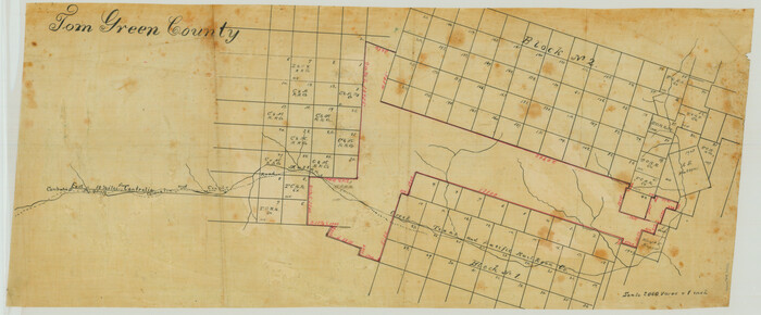
[Sketch in Reagan, Irion and Tom Green Counties]
Print $20.00
- Digital $50.00
[Sketch in Reagan, Irion and Tom Green Counties]
Size: 12.5 x 30.1 inches
75551
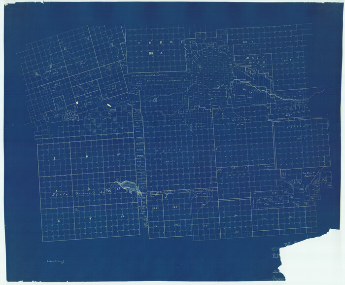
[Map of Tom Green County]
Print $40.00
- Digital $50.00
[Map of Tom Green County]
1933
Size: 50.0 x 60.6 inches
82061
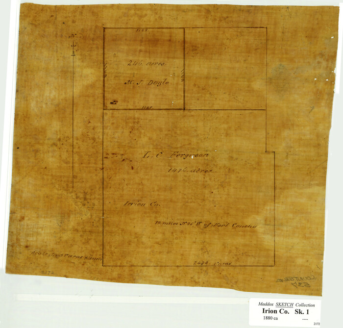
[L.C. Ferguson Survey, Irion County]
Print $3.00
- Digital $50.00
[L.C. Ferguson Survey, Irion County]
Size: 11.8 x 12.3 inches
537
Working Sketch compiled from original field notes showing surveys in Reagan and Irion Counties located by Frank Lerch in 1883 and 1884, also adjacent blocks and surveys (previously located by other surveyors) called for in his Field Notes

Print $20.00
- Digital $50.00
Working Sketch compiled from original field notes showing surveys in Reagan and Irion Counties located by Frank Lerch in 1883 and 1884, also adjacent blocks and surveys (previously located by other surveyors) called for in his Field Notes
1883
Size: 35.8 x 20.0 inches
91749
Working Sketch Compiled from Original Field Showing Surveys in Irion County Located by J. A. McDonald in 1856 and 1858

Print $20.00
- Digital $50.00
Working Sketch Compiled from Original Field Showing Surveys in Irion County Located by J. A. McDonald in 1856 and 1858
Size: 13.1 x 13.8 inches
92191
Working Sketch Compiled From Original Field Notes Showing Surveys in Reagan and Irion Counties

Print $20.00
- Digital $50.00
Working Sketch Compiled From Original Field Notes Showing Surveys in Reagan and Irion Counties
Size: 36.2 x 20.2 inches
92331
Working Sketch Compiled from Original Field Notes Irion County, Texas

Print $20.00
- Digital $50.00
Working Sketch Compiled from Original Field Notes Irion County, Texas
Size: 19.4 x 19.5 inches
92187
Water-Shed of the Colorado River

Print $40.00
- Digital $50.00
Water-Shed of the Colorado River
1925
Size: 37.1 x 79.8 inches
65261
University of Texas System University Lands

Print $20.00
- Digital $50.00
University of Texas System University Lands
1937
Size: 23.3 x 17.6 inches
93237
University Lands, Blocks 38 to 57, Crockett, Reagan, Irion, Schleicher Counties

Print $40.00
- Digital $50.00
University Lands, Blocks 38 to 57, Crockett, Reagan, Irion, Schleicher Counties
Size: 34.0 x 53.0 inches
62946
University Lands Blocks 38 to 57, Crockett-Reagan-Irion-Schleicher-Counties

Print $40.00
- Digital $50.00
University Lands Blocks 38 to 57, Crockett-Reagan-Irion-Schleicher-Counties
1937
Size: 34.2 x 52.7 inches
2444
University Lands Blocks 38 to 57, Crockett-Reagan-Irion-Schleicher-Counties

Print $40.00
- Digital $50.00
University Lands Blocks 38 to 57, Crockett-Reagan-Irion-Schleicher-Counties
Size: 35.1 x 53.6 inches
62945
University Land Field Notes for Blocks 39, 41, 42, 44, 45, 46, 47, 50, and 51 in Crockett County, Blocks 38 and 40 in Crockett and Irion Counties, and Blocks 48 and 49 in Crockett and Reagan Counties, and Block 43 in Crockett, Irion, and Reagan Counties

University Land Field Notes for Blocks 39, 41, 42, 44, 45, 46, 47, 50, and 51 in Crockett County, Blocks 38 and 40 in Crockett and Irion Counties, and Blocks 48 and 49 in Crockett and Reagan Counties, and Block 43 in Crockett, Irion, and Reagan Counties
81718
University Land Field Notes for Block 52 in Crockett, Irion, and Schleicher Counties, Blocks 55 and 56 in Crockett and Schleicher Counties, Block 53 in Irion and Schleicher Counties, and Blocks 54 and 57 in Schleicher County

University Land Field Notes for Block 52 in Crockett, Irion, and Schleicher Counties, Blocks 55 and 56 in Crockett and Schleicher Counties, Block 53 in Irion and Schleicher Counties, and Blocks 54 and 57 in Schleicher County
81719
Tom Green County Working Sketch 15

Print $20.00
- Digital $50.00
Tom Green County Working Sketch 15
1988
Size: 32.9 x 37.5 inches
69384
Tom Green County Sketch File 68

Print $20.00
- Digital $50.00
Tom Green County Sketch File 68
1913
Size: 30.8 x 41.5 inches
10406
Tom Green County Sketch File 63

Print $20.00
- Digital $50.00
Tom Green County Sketch File 63
1890
Size: 31.8 x 17.9 inches
12445
Tom Green County Sketch File 56

Print $20.00
- Digital $50.00
Tom Green County Sketch File 56
1883
Size: 34.5 x 47.5 inches
10404
Tom Green County Sketch File 50

Print $20.00
- Digital $50.00
Tom Green County Sketch File 50
1884
Size: 25.4 x 34.5 inches
12442
Tom Green County Sketch File 14

Print $20.00
- Digital $50.00
Tom Green County Sketch File 14
Size: 34.8 x 45.7 inches
10401
Tom Green County Rolled Sketch 3

Print $20.00
- Digital $50.00
Tom Green County Rolled Sketch 3
Size: 26.8 x 32.8 inches
7993
Tom Green County Rolled Sketch 14

Print $20.00
- Digital $50.00
Tom Green County Rolled Sketch 14
1953
Size: 28.3 x 30.9 inches
7999
Tom Green County Rolled Sketch 14

Print $20.00
- Digital $50.00
Tom Green County Rolled Sketch 14
1953
Size: 26.7 x 28.4 inches
8000
Sterling County Sketch File 6

Print $12.00
- Digital $50.00
Sterling County Sketch File 6
1912
Size: 5.7 x 8.8 inches
37115
Sterling County Sketch File 19

Print $8.00
- Digital $50.00
Sterling County Sketch File 19
1949
Size: 11.2 x 8.6 inches
37169
Sterling County Sketch File 15

Print $8.00
- Digital $50.00
Sterling County Sketch File 15
1935
Size: 11.1 x 8.8 inches
37150
Sterling County Rolled Sketch 16

Print $40.00
- Digital $50.00
Sterling County Rolled Sketch 16
1951
Size: 73.6 x 43.0 inches
9948
Reagan County Working Sketch 2

Print $20.00
- Digital $50.00
Reagan County Working Sketch 2
1919
Size: 28.5 x 19.6 inches
71842
Reagan County Working Sketch 1

Print $20.00
- Digital $50.00
Reagan County Working Sketch 1
1886
Size: 25.0 x 27.3 inches
71841
Reagan County Rolled Sketch 4

Print $20.00
- Digital $50.00
Reagan County Rolled Sketch 4
1928
Size: 25.4 x 27.4 inches
7433
[Sketch in Reagan, Irion and Tom Green Counties]
Print $20.00
- Digital $50.00
[Sketch in Reagan, Irion and Tom Green Counties]
-
Size
12.5 x 30.1 inches
-
Map/Doc
75551
[Map of Tom Green County]
Print $40.00
- Digital $50.00
[Map of Tom Green County]
1933
-
Size
50.0 x 60.6 inches
-
Map/Doc
82061
-
Creation Date
1933
[L.C. Ferguson Survey, Irion County]
Print $3.00
- Digital $50.00
[L.C. Ferguson Survey, Irion County]
-
Size
11.8 x 12.3 inches
-
Map/Doc
537
Working Sketch compiled from original field notes showing surveys in Reagan and Irion Counties located by Frank Lerch in 1883 and 1884, also adjacent blocks and surveys (previously located by other surveyors) called for in his Field Notes
Print $20.00
- Digital $50.00
Working Sketch compiled from original field notes showing surveys in Reagan and Irion Counties located by Frank Lerch in 1883 and 1884, also adjacent blocks and surveys (previously located by other surveyors) called for in his Field Notes
1883
-
Size
35.8 x 20.0 inches
-
Map/Doc
91749
-
Creation Date
1883
Working Sketch Compiled from Original Field Showing Surveys in Irion County Located by J. A. McDonald in 1856 and 1858
Print $20.00
- Digital $50.00
Working Sketch Compiled from Original Field Showing Surveys in Irion County Located by J. A. McDonald in 1856 and 1858
-
Size
13.1 x 13.8 inches
-
Map/Doc
92191
Working Sketch Compiled From Original Field Notes Showing Surveys in Reagan and Irion Counties
Print $20.00
- Digital $50.00
Working Sketch Compiled From Original Field Notes Showing Surveys in Reagan and Irion Counties
-
Size
36.2 x 20.2 inches
-
Map/Doc
92331
Working Sketch Compiled from Original Field Notes Irion County, Texas
Print $20.00
- Digital $50.00
Working Sketch Compiled from Original Field Notes Irion County, Texas
-
Size
19.4 x 19.5 inches
-
Map/Doc
92187
Water-Shed of the Colorado River
Print $40.00
- Digital $50.00
Water-Shed of the Colorado River
1925
-
Size
37.1 x 79.8 inches
-
Map/Doc
65261
-
Creation Date
1925
University of Texas System University Lands
Print $20.00
- Digital $50.00
University of Texas System University Lands
1937
-
Size
23.3 x 17.6 inches
-
Map/Doc
93237
-
Creation Date
1937
University Lands, Blocks 38 to 57, Crockett, Reagan, Irion, Schleicher Counties
Print $40.00
- Digital $50.00
University Lands, Blocks 38 to 57, Crockett, Reagan, Irion, Schleicher Counties
-
Size
34.0 x 53.0 inches
-
Map/Doc
62946
University Lands Blocks 38 to 57, Crockett-Reagan-Irion-Schleicher-Counties
Print $40.00
- Digital $50.00
University Lands Blocks 38 to 57, Crockett-Reagan-Irion-Schleicher-Counties
1937
-
Size
34.2 x 52.7 inches
-
Map/Doc
2444
-
Creation Date
1937
University Lands Blocks 38 to 57, Crockett-Reagan-Irion-Schleicher-Counties
Print $40.00
- Digital $50.00
University Lands Blocks 38 to 57, Crockett-Reagan-Irion-Schleicher-Counties
-
Size
35.1 x 53.6 inches
-
Map/Doc
62945
University Land Field Notes for Blocks 39, 41, 42, 44, 45, 46, 47, 50, and 51 in Crockett County, Blocks 38 and 40 in Crockett and Irion Counties, and Blocks 48 and 49 in Crockett and Reagan Counties, and Block 43 in Crockett, Irion, and Reagan Counties
University Land Field Notes for Blocks 39, 41, 42, 44, 45, 46, 47, 50, and 51 in Crockett County, Blocks 38 and 40 in Crockett and Irion Counties, and Blocks 48 and 49 in Crockett and Reagan Counties, and Block 43 in Crockett, Irion, and Reagan Counties
-
Map/Doc
81718
University Land Field Notes for Block 52 in Crockett, Irion, and Schleicher Counties, Blocks 55 and 56 in Crockett and Schleicher Counties, Block 53 in Irion and Schleicher Counties, and Blocks 54 and 57 in Schleicher County
University Land Field Notes for Block 52 in Crockett, Irion, and Schleicher Counties, Blocks 55 and 56 in Crockett and Schleicher Counties, Block 53 in Irion and Schleicher Counties, and Blocks 54 and 57 in Schleicher County
-
Map/Doc
81719
Tom Green County Working Sketch 15
Print $20.00
- Digital $50.00
Tom Green County Working Sketch 15
1988
-
Size
32.9 x 37.5 inches
-
Map/Doc
69384
-
Creation Date
1988
Tom Green County Sketch File 68
Print $20.00
- Digital $50.00
Tom Green County Sketch File 68
1913
-
Size
30.8 x 41.5 inches
-
Map/Doc
10406
-
Creation Date
1913
Tom Green County Sketch File 63
Print $20.00
- Digital $50.00
Tom Green County Sketch File 63
1890
-
Size
31.8 x 17.9 inches
-
Map/Doc
12445
-
Creation Date
1890
Tom Green County Sketch File 56
Print $20.00
- Digital $50.00
Tom Green County Sketch File 56
1883
-
Size
34.5 x 47.5 inches
-
Map/Doc
10404
-
Creation Date
1883
Tom Green County Sketch File 50
Print $20.00
- Digital $50.00
Tom Green County Sketch File 50
1884
-
Size
25.4 x 34.5 inches
-
Map/Doc
12442
-
Creation Date
1884
Tom Green County Sketch File 14
Print $20.00
- Digital $50.00
Tom Green County Sketch File 14
-
Size
34.8 x 45.7 inches
-
Map/Doc
10401
Tom Green County Rolled Sketch 3
Print $20.00
- Digital $50.00
Tom Green County Rolled Sketch 3
-
Size
26.8 x 32.8 inches
-
Map/Doc
7993
Tom Green County Rolled Sketch 14
Print $20.00
- Digital $50.00
Tom Green County Rolled Sketch 14
1953
-
Size
28.3 x 30.9 inches
-
Map/Doc
7999
-
Creation Date
1953
Tom Green County Rolled Sketch 14
Print $20.00
- Digital $50.00
Tom Green County Rolled Sketch 14
1953
-
Size
26.7 x 28.4 inches
-
Map/Doc
8000
-
Creation Date
1953
Sterling County Sketch File 6
Print $12.00
- Digital $50.00
Sterling County Sketch File 6
1912
-
Size
5.7 x 8.8 inches
-
Map/Doc
37115
-
Creation Date
1912
Sterling County Sketch File 19
Print $8.00
- Digital $50.00
Sterling County Sketch File 19
1949
-
Size
11.2 x 8.6 inches
-
Map/Doc
37169
-
Creation Date
1949
Sterling County Sketch File 15
Print $8.00
- Digital $50.00
Sterling County Sketch File 15
1935
-
Size
11.1 x 8.8 inches
-
Map/Doc
37150
-
Creation Date
1935
Sterling County Rolled Sketch 16
Print $40.00
- Digital $50.00
Sterling County Rolled Sketch 16
1951
-
Size
73.6 x 43.0 inches
-
Map/Doc
9948
-
Creation Date
1951
Reagan County Working Sketch 2
Print $20.00
- Digital $50.00
Reagan County Working Sketch 2
1919
-
Size
28.5 x 19.6 inches
-
Map/Doc
71842
-
Creation Date
1919
Reagan County Working Sketch 1
Print $20.00
- Digital $50.00
Reagan County Working Sketch 1
1886
-
Size
25.0 x 27.3 inches
-
Map/Doc
71841
-
Creation Date
1886
Reagan County Rolled Sketch 4
Print $20.00
- Digital $50.00
Reagan County Rolled Sketch 4
1928
-
Size
25.4 x 27.4 inches
-
Map/Doc
7433
-
Creation Date
1928