Irion County Rolled Sketch 23

Print $40.00
- Digital $50.00
Irion County Rolled Sketch 23
Size: 42.9 x 49.1 inches
10302
Tom Green County Sketch File 14

Print $20.00
- Digital $50.00
Tom Green County Sketch File 14
Size: 34.8 x 45.7 inches
10401
Irion County Sketch File 17

Print $20.00
- Digital $50.00
Irion County Sketch File 17
Size: 26.7 x 40.5 inches
10617
Irion County Sketch File 8

Print $6.00
- Digital $50.00
Irion County Sketch File 8
Size: 14.5 x 9.8 inches
27473
Irion County Sketch File 18

Print $10.00
- Digital $50.00
Irion County Sketch File 18
Size: 11.2 x 8.7 inches
27494
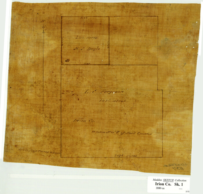
[L.C. Ferguson Survey, Irion County]
Print $3.00
- Digital $50.00
[L.C. Ferguson Survey, Irion County]
Size: 11.8 x 12.3 inches
537
Irion County Boundary File 1

Print $36.00
- Digital $50.00
Irion County Boundary File 1
Size: 8.9 x 4.1 inches
55316
Irion County Boundary File 1a

Print $40.00
- Digital $50.00
Irion County Boundary File 1a
Size: 33.5 x 9.3 inches
55325
Irion County Boundary File 2

Print $60.00
- Digital $50.00
Irion County Boundary File 2
Size: 14.3 x 8.9 inches
55327
Irion County Boundary File 3

Print $38.00
- Digital $50.00
Irion County Boundary File 3
Size: 8.8 x 4.2 inches
55339
Irion County Boundary File 3a

Print $2.00
- Digital $50.00
Irion County Boundary File 3a
Size: 12.9 x 8.3 inches
55349
Irion County Boundary File 4

Print $23.00
- Digital $50.00
Irion County Boundary File 4
Size: 11.2 x 8.8 inches
55350
Irion County Boundary File 4a

Print $40.00
- Digital $50.00
Irion County Boundary File 4a
Size: 8.6 x 38.7 inches
55361
University Lands Blocks 38 to 57, Crockett-Reagan-Irion-Schleicher-Counties

Print $40.00
- Digital $50.00
University Lands Blocks 38 to 57, Crockett-Reagan-Irion-Schleicher-Counties
Size: 35.1 x 53.6 inches
62945
University Lands, Blocks 38 to 57, Crockett, Reagan, Irion, Schleicher Counties

Print $40.00
- Digital $50.00
University Lands, Blocks 38 to 57, Crockett, Reagan, Irion, Schleicher Counties
Size: 34.0 x 53.0 inches
62946
Irion County Rolled Sketch 2

Print $20.00
- Digital $50.00
Irion County Rolled Sketch 2
Size: 27.8 x 39.7 inches
6317
Irion County Rolled Sketch 3

Print $20.00
- Digital $50.00
Irion County Rolled Sketch 3
Size: 26.2 x 27.5 inches
6318
Irion County Rolled Sketch 4

Print $20.00
- Digital $50.00
Irion County Rolled Sketch 4
Size: 25.6 x 36.4 inches
6319
Irion County Rolled Sketch 6

Print $20.00
- Digital $50.00
Irion County Rolled Sketch 6
Size: 23.6 x 39.9 inches
6320
Irion County Rolled Sketch 18A

Print $20.00
- Digital $50.00
Irion County Rolled Sketch 18A
Size: 45.5 x 29.8 inches
6327
Irion County Rolled Sketch 19

Print $20.00
- Digital $50.00
Irion County Rolled Sketch 19
Size: 19.3 x 27.5 inches
6328
Irion County Working Sketch 1

Print $20.00
- Digital $50.00
Irion County Working Sketch 1
Size: 24.3 x 26.8 inches
66410
Reagan County Rolled Sketch 13

Print $20.00
- Digital $50.00
Reagan County Rolled Sketch 13
Size: 25.5 x 38.0 inches
7441
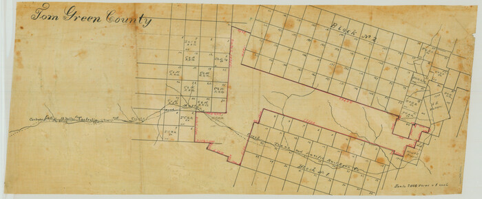
[Sketch in Reagan, Irion and Tom Green Counties]
Print $20.00
- Digital $50.00
[Sketch in Reagan, Irion and Tom Green Counties]
Size: 12.5 x 30.1 inches
75551
Andrews County Rolled Sketch 42

Print $20.00
- Digital $50.00
Andrews County Rolled Sketch 42
Size: 27.3 x 36.0 inches
77182
Tom Green County Rolled Sketch 3

Print $20.00
- Digital $50.00
Tom Green County Rolled Sketch 3
Size: 26.8 x 32.8 inches
7993
University Land Field Notes for Blocks 39, 41, 42, 44, 45, 46, 47, 50, and 51 in Crockett County, Blocks 38 and 40 in Crockett and Irion Counties, and Blocks 48 and 49 in Crockett and Reagan Counties, and Block 43 in Crockett, Irion, and Reagan Counties

University Land Field Notes for Blocks 39, 41, 42, 44, 45, 46, 47, 50, and 51 in Crockett County, Blocks 38 and 40 in Crockett and Irion Counties, and Blocks 48 and 49 in Crockett and Reagan Counties, and Block 43 in Crockett, Irion, and Reagan Counties
81718
University Land Field Notes for Block 52 in Crockett, Irion, and Schleicher Counties, Blocks 55 and 56 in Crockett and Schleicher Counties, Block 53 in Irion and Schleicher Counties, and Blocks 54 and 57 in Schleicher County

University Land Field Notes for Block 52 in Crockett, Irion, and Schleicher Counties, Blocks 55 and 56 in Crockett and Schleicher Counties, Block 53 in Irion and Schleicher Counties, and Blocks 54 and 57 in Schleicher County
81719
Working Sketch Compiled from Original Field Notes Irion County, Texas

Print $20.00
- Digital $50.00
Working Sketch Compiled from Original Field Notes Irion County, Texas
Size: 19.4 x 19.5 inches
92187
Working Sketch Compiled from Original Field Showing Surveys in Irion County Located by J. A. McDonald in 1856 and 1858

Print $20.00
- Digital $50.00
Working Sketch Compiled from Original Field Showing Surveys in Irion County Located by J. A. McDonald in 1856 and 1858
Size: 13.1 x 13.8 inches
92191
Irion County Rolled Sketch 23
Print $40.00
- Digital $50.00
Irion County Rolled Sketch 23
-
Size
42.9 x 49.1 inches
-
Map/Doc
10302
Tom Green County Sketch File 14
Print $20.00
- Digital $50.00
Tom Green County Sketch File 14
-
Size
34.8 x 45.7 inches
-
Map/Doc
10401
Irion County Sketch File 17
Print $20.00
- Digital $50.00
Irion County Sketch File 17
-
Size
26.7 x 40.5 inches
-
Map/Doc
10617
Irion County Sketch File 8
Print $6.00
- Digital $50.00
Irion County Sketch File 8
-
Size
14.5 x 9.8 inches
-
Map/Doc
27473
Irion County Sketch File 18
Print $10.00
- Digital $50.00
Irion County Sketch File 18
-
Size
11.2 x 8.7 inches
-
Map/Doc
27494
[L.C. Ferguson Survey, Irion County]
Print $3.00
- Digital $50.00
[L.C. Ferguson Survey, Irion County]
-
Size
11.8 x 12.3 inches
-
Map/Doc
537
Irion County Boundary File 1
Print $36.00
- Digital $50.00
Irion County Boundary File 1
-
Size
8.9 x 4.1 inches
-
Map/Doc
55316
Irion County Boundary File 1a
Print $40.00
- Digital $50.00
Irion County Boundary File 1a
-
Size
33.5 x 9.3 inches
-
Map/Doc
55325
Irion County Boundary File 2
Print $60.00
- Digital $50.00
Irion County Boundary File 2
-
Size
14.3 x 8.9 inches
-
Map/Doc
55327
Irion County Boundary File 3
Print $38.00
- Digital $50.00
Irion County Boundary File 3
-
Size
8.8 x 4.2 inches
-
Map/Doc
55339
Irion County Boundary File 3a
Print $2.00
- Digital $50.00
Irion County Boundary File 3a
-
Size
12.9 x 8.3 inches
-
Map/Doc
55349
Irion County Boundary File 4
Print $23.00
- Digital $50.00
Irion County Boundary File 4
-
Size
11.2 x 8.8 inches
-
Map/Doc
55350
Irion County Boundary File 4a
Print $40.00
- Digital $50.00
Irion County Boundary File 4a
-
Size
8.6 x 38.7 inches
-
Map/Doc
55361
University Lands Blocks 38 to 57, Crockett-Reagan-Irion-Schleicher-Counties
Print $40.00
- Digital $50.00
University Lands Blocks 38 to 57, Crockett-Reagan-Irion-Schleicher-Counties
-
Size
35.1 x 53.6 inches
-
Map/Doc
62945
University Lands, Blocks 38 to 57, Crockett, Reagan, Irion, Schleicher Counties
Print $40.00
- Digital $50.00
University Lands, Blocks 38 to 57, Crockett, Reagan, Irion, Schleicher Counties
-
Size
34.0 x 53.0 inches
-
Map/Doc
62946
Irion County Rolled Sketch 2
Print $20.00
- Digital $50.00
Irion County Rolled Sketch 2
-
Size
27.8 x 39.7 inches
-
Map/Doc
6317
Irion County Rolled Sketch 3
Print $20.00
- Digital $50.00
Irion County Rolled Sketch 3
-
Size
26.2 x 27.5 inches
-
Map/Doc
6318
Irion County Rolled Sketch 4
Print $20.00
- Digital $50.00
Irion County Rolled Sketch 4
-
Size
25.6 x 36.4 inches
-
Map/Doc
6319
Irion County Rolled Sketch 6
Print $20.00
- Digital $50.00
Irion County Rolled Sketch 6
-
Size
23.6 x 39.9 inches
-
Map/Doc
6320
Irion County Rolled Sketch 18A
Print $20.00
- Digital $50.00
Irion County Rolled Sketch 18A
-
Size
45.5 x 29.8 inches
-
Map/Doc
6327
Irion County Rolled Sketch 19
Print $20.00
- Digital $50.00
Irion County Rolled Sketch 19
-
Size
19.3 x 27.5 inches
-
Map/Doc
6328
Irion County Working Sketch 1
Print $20.00
- Digital $50.00
Irion County Working Sketch 1
-
Size
24.3 x 26.8 inches
-
Map/Doc
66410
Reagan County Rolled Sketch 13
Print $20.00
- Digital $50.00
Reagan County Rolled Sketch 13
-
Size
25.5 x 38.0 inches
-
Map/Doc
7441
[Sketch in Reagan, Irion and Tom Green Counties]
Print $20.00
- Digital $50.00
[Sketch in Reagan, Irion and Tom Green Counties]
-
Size
12.5 x 30.1 inches
-
Map/Doc
75551
Andrews County Rolled Sketch 42
Print $20.00
- Digital $50.00
Andrews County Rolled Sketch 42
-
Size
27.3 x 36.0 inches
-
Map/Doc
77182
Tom Green County Rolled Sketch 3
Print $20.00
- Digital $50.00
Tom Green County Rolled Sketch 3
-
Size
26.8 x 32.8 inches
-
Map/Doc
7993
University Land Field Notes for Blocks 39, 41, 42, 44, 45, 46, 47, 50, and 51 in Crockett County, Blocks 38 and 40 in Crockett and Irion Counties, and Blocks 48 and 49 in Crockett and Reagan Counties, and Block 43 in Crockett, Irion, and Reagan Counties
University Land Field Notes for Blocks 39, 41, 42, 44, 45, 46, 47, 50, and 51 in Crockett County, Blocks 38 and 40 in Crockett and Irion Counties, and Blocks 48 and 49 in Crockett and Reagan Counties, and Block 43 in Crockett, Irion, and Reagan Counties
-
Map/Doc
81718
University Land Field Notes for Block 52 in Crockett, Irion, and Schleicher Counties, Blocks 55 and 56 in Crockett and Schleicher Counties, Block 53 in Irion and Schleicher Counties, and Blocks 54 and 57 in Schleicher County
University Land Field Notes for Block 52 in Crockett, Irion, and Schleicher Counties, Blocks 55 and 56 in Crockett and Schleicher Counties, Block 53 in Irion and Schleicher Counties, and Blocks 54 and 57 in Schleicher County
-
Map/Doc
81719
Working Sketch Compiled from Original Field Notes Irion County, Texas
Print $20.00
- Digital $50.00
Working Sketch Compiled from Original Field Notes Irion County, Texas
-
Size
19.4 x 19.5 inches
-
Map/Doc
92187
Working Sketch Compiled from Original Field Showing Surveys in Irion County Located by J. A. McDonald in 1856 and 1858
Print $20.00
- Digital $50.00
Working Sketch Compiled from Original Field Showing Surveys in Irion County Located by J. A. McDonald in 1856 and 1858
-
Size
13.1 x 13.8 inches
-
Map/Doc
92191