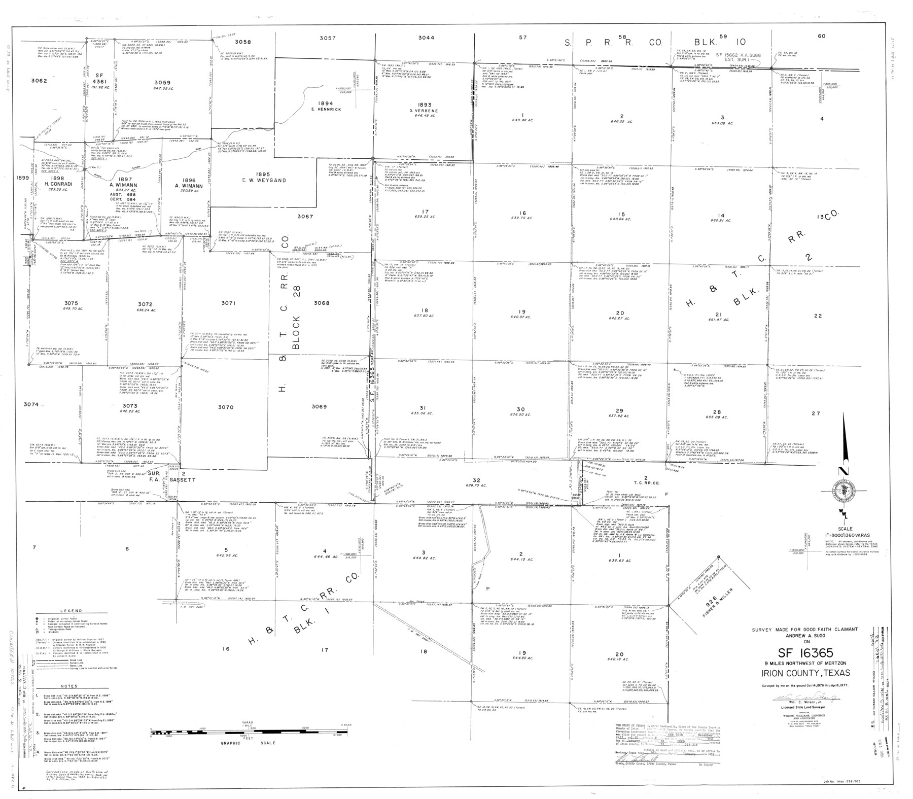
Irion County Rolled Sketch 23
Survey made for Good Faith Claimant Andrew A. Sugg on SF-16365
-
Map/Doc
10302
-
Collection
General Map Collection
-
Object Dates
1977/4/8 (Survey Date)
1978/1/9 (File Date)
-
People and Organizations
Wm. C. Wilson, Jr. (Surveyor/Engineer)
-
Counties
Irion
-
Subjects
Surveying Rolled Sketch
-
Height x Width
42.9 x 49.1 inches
109.0 x 124.7 cm
-
Scale
1" = 360 varas
Part of: General Map Collection
Map of Kendall County

Print $20.00
- Digital $50.00
Map of Kendall County
1862
Size 21.0 x 20.0 inches
Map/Doc 3754
McMullen County

Print $20.00
- Digital $50.00
McMullen County
1967
Size 40.7 x 27.8 inches
Map/Doc 77363
Galveston County NRC Article 33.136 Sketch 31

Print $22.00
- Digital $50.00
Galveston County NRC Article 33.136 Sketch 31
2005
Size 22.2 x 33.7 inches
Map/Doc 83280
Stephens County Sketch File 24

Print $5.00
- Digital $50.00
Stephens County Sketch File 24
1952
Size 24.5 x 32.5 inches
Map/Doc 12354
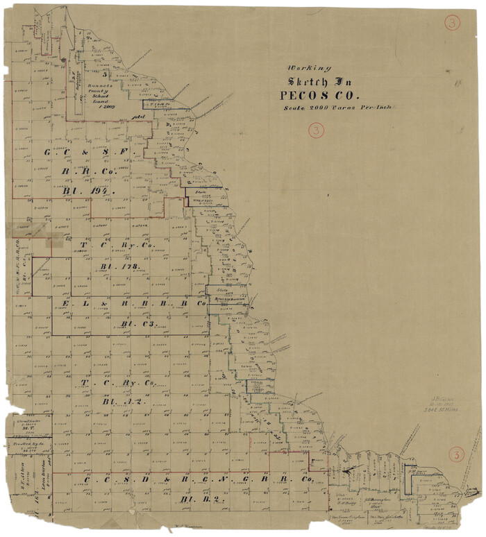
Pecos County Working Sketch 3
Print $20.00
- Digital $50.00
Pecos County Working Sketch 3
1927
Map/Doc 71473
Bosque County Sketch File 7

Print $4.00
- Digital $50.00
Bosque County Sketch File 7
1852
Size 12.7 x 7.7 inches
Map/Doc 14750
Henderson County Sketch File 15

Print $4.00
- Digital $50.00
Henderson County Sketch File 15
1890
Size 8.1 x 13.1 inches
Map/Doc 26357
Terrell County Sketch File 28

Print $20.00
- Digital $50.00
Terrell County Sketch File 28
1939
Size 18.3 x 22.8 inches
Map/Doc 12425
Surveyor's Watercourse Report 2

Print $42.00
Surveyor's Watercourse Report 2
2025
Size 11.0 x 8.5 inches
Map/Doc 97512

Val Verde County Sketch File XXX9

Print $4.00
- Digital $50.00
Val Verde County Sketch File XXX9
Size 11.0 x 8.5 inches
Map/Doc 39108
Garza County Sketch File 19

Print $20.00
- Digital $50.00
Garza County Sketch File 19
1905
Size 21.8 x 23.0 inches
Map/Doc 11546
You may also like
Sabine Bank to East Bay including Heald Bank

Print $20.00
- Digital $50.00
Sabine Bank to East Bay including Heald Bank
1967
Size 45.1 x 34.3 inches
Map/Doc 69848
Flight Mission No. CRE-3R, Frame 42, Jackson County

Print $20.00
- Digital $50.00
Flight Mission No. CRE-3R, Frame 42, Jackson County
1956
Size 18.6 x 22.4 inches
Map/Doc 85389
Terrell County Working Sketch 51

Print $40.00
- Digital $50.00
Terrell County Working Sketch 51
1958
Size 63.7 x 43.6 inches
Map/Doc 62144

Brazos River, Brazos River Sheet 2

Print $20.00
- Digital $50.00
Brazos River, Brazos River Sheet 2
1926
Size 25.2 x 31.0 inches
Map/Doc 78265
Runnels County Rolled Sketch 32

Print $20.00
- Digital $50.00
Runnels County Rolled Sketch 32
Size 34.9 x 44.5 inches
Map/Doc 9868
Presidio County Working Sketch 62

Print $3.00
- Digital $50.00
Presidio County Working Sketch 62
1958
Size 12.6 x 9.5 inches
Map/Doc 71739
Sketch of Resurvey of J. R. Castlebury Est., SF 12725 in Gregg County

Print $20.00
- Digital $50.00
Sketch of Resurvey of J. R. Castlebury Est., SF 12725 in Gregg County
1931
Size 38.6 x 33.3 inches
Map/Doc 2039
Kaufman County

Print $20.00
- Digital $50.00
Kaufman County
1942
Size 46.6 x 38.2 inches
Map/Doc 1871
Van Zandt County Boundary File 2

Print $32.00
- Digital $50.00
Van Zandt County Boundary File 2
Size 13.0 x 8.1 inches
Map/Doc 59633
Pecos County Rolled Sketch DK3

Print $20.00
- Digital $50.00
Pecos County Rolled Sketch DK3
1938
Size 35.3 x 42.3 inches
Map/Doc 9715
Flight Mission No. CLL-1N, Frame 158, Willacy County

Print $20.00
- Digital $50.00
Flight Mission No. CLL-1N, Frame 158, Willacy County
1954
Size 18.4 x 22.1 inches
Map/Doc 87049