Bandera County Sketch File 19

Print $40.00
- Digital $50.00
Bandera County Sketch File 19
Size: 15.9 x 18.9 inches
10893
Bandera County Sketch File 28

Print $40.00
- Digital $50.00
Bandera County Sketch File 28
Size: 23.5 x 20.0 inches
10897
Bandera County Sketch File 37

Print $24.00
Bandera County Sketch File 37
Size: 11.0 x 8.5 inches
97248
Bandera County Working Sketch 28

Print $20.00
- Digital $50.00
Bandera County Working Sketch 28
1953
Size: 24.8 x 19.5 inches
67624
Bandera County Working Sketch 41

Print $20.00
- Digital $50.00
Bandera County Working Sketch 41
1977
Size: 31.3 x 37.7 inches
67637
Bandera County Working Sketch 9

Print $20.00
- Digital $50.00
Bandera County Working Sketch 9
1920
Size: 15.2 x 17.1 inches
67602
Edwards County Rolled Sketch 7

Print $20.00
- Digital $50.00
Edwards County Rolled Sketch 7
1881
Size: 24.4 x 23.2 inches
5800
Edwards County Rolled Sketch 8

Print $20.00
- Digital $50.00
Edwards County Rolled Sketch 8
1891
Size: 16.0 x 18.7 inches
5801
Edwards County Sketch File 11

Print $26.00
- Digital $50.00
Edwards County Sketch File 11
1887
Size: 13.7 x 8.8 inches
21687
Edwards County Sketch File A

Print $20.00
- Digital $50.00
Edwards County Sketch File A
Size: 25.3 x 35.5 inches
11448
Edwards County Sketch File A13

Print $20.00
- Digital $50.00
Edwards County Sketch File A13
1901
Size: 22.8 x 46.6 inches
10444
General Highway Map, Kerr County, Texas

Print $20.00
General Highway Map, Kerr County, Texas
1940
Size: 24.8 x 18.2 inches
79157
General Highway Map, Kerr County, Texas

Print $20.00
General Highway Map, Kerr County, Texas
1940
Size: 25.0 x 18.4 inches
79158
General Highway Map, Kerr County, Texas

Print $20.00
General Highway Map, Kerr County, Texas
1961
Size: 24.8 x 18.2 inches
79551
General Highway Map, Kerr County, Texas

Print $20.00
General Highway Map, Kerr County, Texas
1961
Size: 24.6 x 18.2 inches
79552
Gillespie County Rolled Sketch 6

Print $20.00
- Digital $50.00
Gillespie County Rolled Sketch 6
2005
Size: 18.2 x 24.6 inches
83253
Gillespie County Working Sketch 5

Print $20.00
- Digital $50.00
Gillespie County Working Sketch 5
1972
Size: 25.7 x 25.9 inches
63168
Guadalupe River, Watershed [of the Guadalupe River]
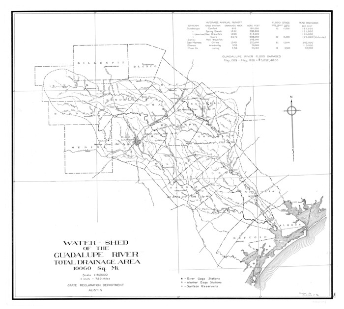
Print $6.00
- Digital $50.00
Guadalupe River, Watershed [of the Guadalupe River]
1925
Size: 30.1 x 33.4 inches
65059
Kendall County Sketch File 22

Print $20.00
- Digital $50.00
Kendall County Sketch File 22
1926
Size: 17.0 x 25.8 inches
11910
Kerr County Boundary File 1

Print $4.00
- Digital $50.00
Kerr County Boundary File 1
Size: 12.7 x 8.1 inches
55982
Kerr County Boundary File 2

Print $46.00
- Digital $50.00
Kerr County Boundary File 2
Size: 15.6 x 26.5 inches
55984
Kerr County Boundary File 3

Print $6.00
- Digital $50.00
Kerr County Boundary File 3
Size: 11.3 x 8.8 inches
55998
Kerr County Boundary File 4

Print $4.00
- Digital $50.00
Kerr County Boundary File 4
Size: 11.1 x 8.3 inches
64799
Kerr County Boundary File 4a

Print $16.00
- Digital $50.00
Kerr County Boundary File 4a
Size: 6.1 x 8.2 inches
64801
Kerr County Boundary File 4b

Print $14.00
- Digital $50.00
Kerr County Boundary File 4b
Size: 14.3 x 8.8 inches
64809
Bandera County Sketch File 19
Print $40.00
- Digital $50.00
Bandera County Sketch File 19
-
Size
15.9 x 18.9 inches
-
Map/Doc
10893
Bandera County Sketch File 28
Print $40.00
- Digital $50.00
Bandera County Sketch File 28
-
Size
23.5 x 20.0 inches
-
Map/Doc
10897
Bandera County Sketch File 37
Print $24.00
Bandera County Sketch File 37
-
Size
11.0 x 8.5 inches
-
Map/Doc
97248
Bandera County Working Sketch 28
Print $20.00
- Digital $50.00
Bandera County Working Sketch 28
1953
-
Size
24.8 x 19.5 inches
-
Map/Doc
67624
-
Creation Date
1953
Bandera County Working Sketch 41
Print $20.00
- Digital $50.00
Bandera County Working Sketch 41
1977
-
Size
31.3 x 37.7 inches
-
Map/Doc
67637
-
Creation Date
1977
Bandera County Working Sketch 9
Print $20.00
- Digital $50.00
Bandera County Working Sketch 9
1920
-
Size
15.2 x 17.1 inches
-
Map/Doc
67602
-
Creation Date
1920
Edwards County Rolled Sketch 7
Print $20.00
- Digital $50.00
Edwards County Rolled Sketch 7
1881
-
Size
24.4 x 23.2 inches
-
Map/Doc
5800
-
Creation Date
1881
Edwards County Rolled Sketch 8
Print $20.00
- Digital $50.00
Edwards County Rolled Sketch 8
1891
-
Size
16.0 x 18.7 inches
-
Map/Doc
5801
-
Creation Date
1891
Edwards County Sketch File 11
Print $26.00
- Digital $50.00
Edwards County Sketch File 11
1887
-
Size
13.7 x 8.8 inches
-
Map/Doc
21687
-
Creation Date
1887
Edwards County Sketch File A
Print $20.00
- Digital $50.00
Edwards County Sketch File A
-
Size
25.3 x 35.5 inches
-
Map/Doc
11448
Edwards County Sketch File A13
Print $20.00
- Digital $50.00
Edwards County Sketch File A13
1901
-
Size
22.8 x 46.6 inches
-
Map/Doc
10444
-
Creation Date
1901
General Highway Map, Kerr County, Texas
Print $20.00
General Highway Map, Kerr County, Texas
1940
-
Size
24.8 x 18.2 inches
-
Map/Doc
79157
-
Creation Date
1940
General Highway Map, Kerr County, Texas
Print $20.00
General Highway Map, Kerr County, Texas
1940
-
Size
25.0 x 18.4 inches
-
Map/Doc
79158
-
Creation Date
1940
General Highway Map, Kerr County, Texas
Print $20.00
General Highway Map, Kerr County, Texas
1961
-
Size
24.8 x 18.2 inches
-
Map/Doc
79551
-
Creation Date
1961
General Highway Map, Kerr County, Texas
Print $20.00
General Highway Map, Kerr County, Texas
1961
-
Size
24.6 x 18.2 inches
-
Map/Doc
79552
-
Creation Date
1961
Gillespie County Rolled Sketch 6
Print $20.00
- Digital $50.00
Gillespie County Rolled Sketch 6
2005
-
Size
18.2 x 24.6 inches
-
Map/Doc
83253
-
Creation Date
2005
Gillespie County Working Sketch 5
Print $20.00
- Digital $50.00
Gillespie County Working Sketch 5
1972
-
Size
25.7 x 25.9 inches
-
Map/Doc
63168
-
Creation Date
1972
Guadalupe River, Watershed [of the Guadalupe River]
Print $6.00
- Digital $50.00
Guadalupe River, Watershed [of the Guadalupe River]
1925
-
Size
30.1 x 33.4 inches
-
Map/Doc
65059
-
Creation Date
1925
Kendall County Sketch File 22
Print $20.00
- Digital $50.00
Kendall County Sketch File 22
1926
-
Size
17.0 x 25.8 inches
-
Map/Doc
11910
-
Creation Date
1926
Kerr County

Print $40.00
- Digital $50.00
Kerr County
1923
-
Size
41.0 x 55.8 inches
-
Map/Doc
1874
-
Creation Date
1923
Kerr County

Print $20.00
- Digital $50.00
Kerr County
1873
-
Size
18.3 x 20.6 inches
-
Map/Doc
3761
-
Creation Date
1873
Kerr County

Print $40.00
- Digital $50.00
Kerr County
1923
-
Size
40.9 x 55.5 inches
-
Map/Doc
73206
-
Creation Date
1923
Kerr County

Print $40.00
- Digital $50.00
Kerr County
1923
-
Size
40.3 x 54.2 inches
-
Map/Doc
77339
-
Creation Date
1923
Kerr County

Print $40.00
- Digital $50.00
Kerr County
1925
-
Size
42.0 x 56.5 inches
-
Map/Doc
95556
-
Creation Date
1925
Kerr County Boundary File 1
Print $4.00
- Digital $50.00
Kerr County Boundary File 1
-
Size
12.7 x 8.1 inches
-
Map/Doc
55982
Kerr County Boundary File 2
Print $46.00
- Digital $50.00
Kerr County Boundary File 2
-
Size
15.6 x 26.5 inches
-
Map/Doc
55984
Kerr County Boundary File 3
Print $6.00
- Digital $50.00
Kerr County Boundary File 3
-
Size
11.3 x 8.8 inches
-
Map/Doc
55998
Kerr County Boundary File 4
Print $4.00
- Digital $50.00
Kerr County Boundary File 4
-
Size
11.1 x 8.3 inches
-
Map/Doc
64799
Kerr County Boundary File 4a
Print $16.00
- Digital $50.00
Kerr County Boundary File 4a
-
Size
6.1 x 8.2 inches
-
Map/Doc
64801
Kerr County Boundary File 4b
Print $14.00
- Digital $50.00
Kerr County Boundary File 4b
-
Size
14.3 x 8.8 inches
-
Map/Doc
64809