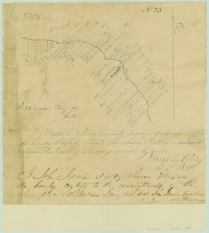
[Surveys near the Guadalupe River]
Print $2.00
- Digital $50.00
[Surveys near the Guadalupe River]
1847
Size: 8.8 x 7.9 inches
288
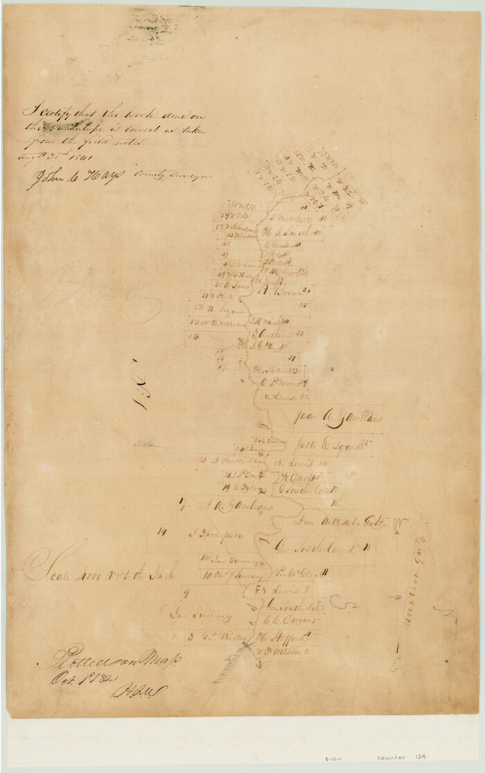
[Surveys in the Bexar District along the Guadalupe River]
Print $3.00
- Digital $50.00
[Surveys in the Bexar District along the Guadalupe River]
1841
Size: 17.2 x 10.8 inches
124
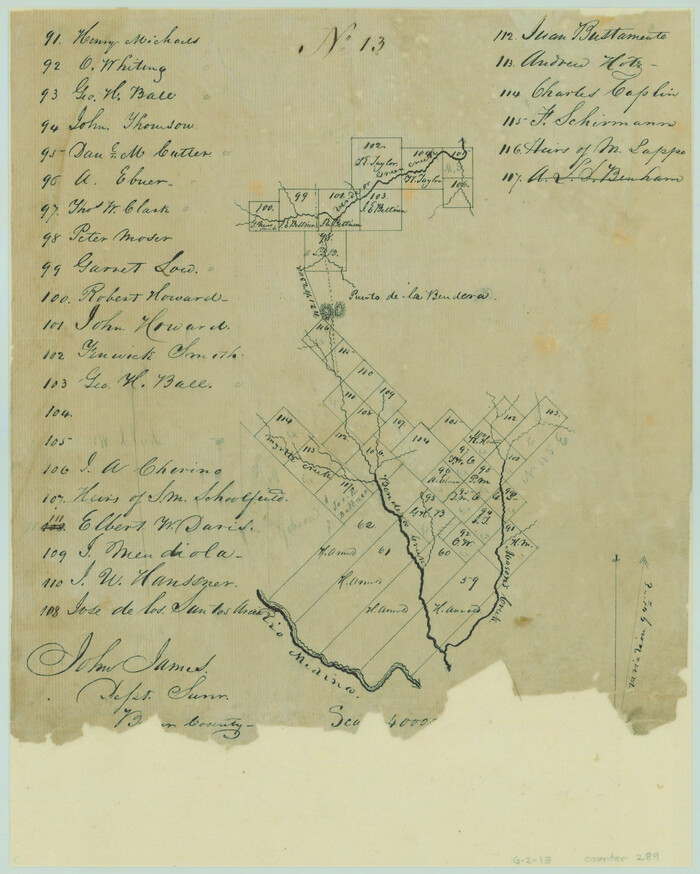
[Surveys along Verde and Bandera Creeks]
Print $2.00
- Digital $50.00
[Surveys along Verde and Bandera Creeks]
1846
Size: 10.0 x 8.0 inches
289
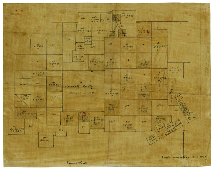
[Surveying Sketch of Kendall County School Land, et al in Kerr County, Texas]
Print $3.00
- Digital $50.00
[Surveying Sketch of Kendall County School Land, et al in Kerr County, Texas]
Size: 11.9 x 12.9 inches
5072
[San Antonio & Aransas Pass Railway Co.]
Print $20.00
- Digital $50.00
[San Antonio & Aransas Pass Railway Co.]
Size: 18.5 x 29.4 inches
64260
Water-Shed of the Colorado River

Print $40.00
- Digital $50.00
Water-Shed of the Colorado River
1925
Size: 37.1 x 79.8 inches
65261
Right of Way & Track Map, San Antonio & Aransas Pass Railway Co.

Print $40.00
- Digital $50.00
Right of Way & Track Map, San Antonio & Aransas Pass Railway Co.
1919
Size: 25.3 x 56.5 inches
64213
Right of Way & Track Map, San Antonio & Aransas Pass Railway Co.

Print $40.00
- Digital $50.00
Right of Way & Track Map, San Antonio & Aransas Pass Railway Co.
1919
Size: 25.3 x 56.6 inches
64214
Real County Sketch File 16

Print $20.00
- Digital $50.00
Real County Sketch File 16
1934
Size: 23.1 x 22.1 inches
12234
Real County Sketch File 15

Print $8.00
- Digital $50.00
Real County Sketch File 15
1933
Size: 14.3 x 8.6 inches
35069
Plat of Proposed County

Print $20.00
- Digital $50.00
Plat of Proposed County
1909
Size: 23.9 x 30.8 inches
1712
Map showing portion of 140 acre tract owned by Schriener Institute near Kerrville, Texas

Print $40.00
- Digital $50.00
Map showing portion of 140 acre tract owned by Schriener Institute near Kerrville, Texas
1922
Size: 31.6 x 53.0 inches
89443
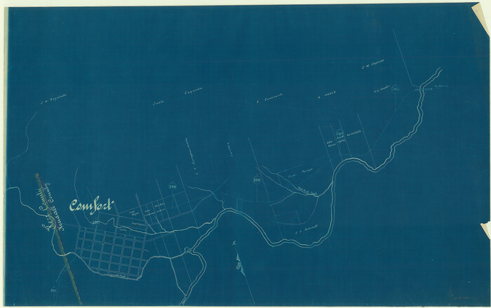
Map of Kerr County, Texas

Print $20.00
- Digital $50.00
Map of Kerr County, Texas
1879
Size: 21.7 x 28.5 inches
526
Map of Kerr County Texas

Print $20.00
- Digital $50.00
Map of Kerr County Texas
1879
Size: 20.3 x 28.3 inches
3763
Map of Kerr County Texas

Print $20.00
- Digital $50.00
Map of Kerr County Texas
1879
Size: 20.5 x 28.5 inches
4575
Map of Kerr County

Print $20.00
- Digital $50.00
Map of Kerr County
1864
Size: 14.8 x 17.9 inches
3760
Map of Kerr County

Print $20.00
- Digital $50.00
Map of Kerr County
1878
Size: 20.5 x 25.7 inches
3762
Map of Kerr County

Print $20.00
- Digital $50.00
Map of Kerr County
1869
Size: 22.2 x 32.1 inches
3764
Map of Kerr County

Print $40.00
- Digital $50.00
Map of Kerr County
1895
Size: 39.7 x 48.9 inches
5002
Map of Kerr County

Print $40.00
- Digital $50.00
Map of Kerr County
1895
Size: 41.3 x 57.1 inches
7824
Kimble County Working Sketch 74

Print $20.00
- Digital $50.00
Kimble County Working Sketch 74
1966
Size: 43.1 x 34.2 inches
70142
Kimble County Working Sketch 6

Print $20.00
- Digital $50.00
Kimble County Working Sketch 6
1915
Size: 24.4 x 26.5 inches
70074
Kerr County Working Sketch Graphic Index

Print $40.00
- Digital $50.00
Kerr County Working Sketch Graphic Index
1923
Size: 40.4 x 55.9 inches
76605
Kerr County Working Sketch 9

Print $20.00
- Digital $50.00
Kerr County Working Sketch 9
1949
Size: 31.6 x 33.0 inches
70040
Kerr County Working Sketch 8

Print $20.00
- Digital $50.00
Kerr County Working Sketch 8
1948
Size: 18.1 x 23.6 inches
70039
Kerr County Working Sketch 7

Print $20.00
- Digital $50.00
Kerr County Working Sketch 7
1947
Size: 38.9 x 30.8 inches
70038
Kerr County Working Sketch 6

Print $20.00
- Digital $50.00
Kerr County Working Sketch 6
1947
Size: 32.8 x 26.3 inches
70037
Kerr County Working Sketch 5

Print $20.00
- Digital $50.00
Kerr County Working Sketch 5
1947
Size: 21.9 x 19.8 inches
70036
[Surveys near the Guadalupe River]
Print $2.00
- Digital $50.00
[Surveys near the Guadalupe River]
1847
-
Size
8.8 x 7.9 inches
-
Map/Doc
288
-
Creation Date
1847
[Surveys in the Bexar District along the Guadalupe River]
Print $3.00
- Digital $50.00
[Surveys in the Bexar District along the Guadalupe River]
1841
-
Size
17.2 x 10.8 inches
-
Map/Doc
124
-
Creation Date
1841
[Surveys along Verde and Bandera Creeks]
Print $2.00
- Digital $50.00
[Surveys along Verde and Bandera Creeks]
1846
-
Size
10.0 x 8.0 inches
-
Map/Doc
289
-
Creation Date
1846
[Surveying Sketch of Kendall County School Land, et al in Kerr County, Texas]
Print $3.00
- Digital $50.00
[Surveying Sketch of Kendall County School Land, et al in Kerr County, Texas]
-
Size
11.9 x 12.9 inches
-
Map/Doc
5072
[San Antonio & Aransas Pass Railway Co.]
Print $20.00
- Digital $50.00
[San Antonio & Aransas Pass Railway Co.]
-
Size
18.5 x 29.4 inches
-
Map/Doc
64260
Water-Shed of the Colorado River
Print $40.00
- Digital $50.00
Water-Shed of the Colorado River
1925
-
Size
37.1 x 79.8 inches
-
Map/Doc
65261
-
Creation Date
1925
Texas Hill Country Trail Region

Texas Hill Country Trail Region
2017
-
Size
18.2 x 24.3 inches
-
Map/Doc
96871
-
Creation Date
2017
Texas Hill Country Trail Region

Texas Hill Country Trail Region
-
Size
18.1 x 24.2 inches
-
Map/Doc
96872
Right of Way & Track Map, San Antonio & Aransas Pass Railway Co.
Print $40.00
- Digital $50.00
Right of Way & Track Map, San Antonio & Aransas Pass Railway Co.
1919
-
Size
25.3 x 56.5 inches
-
Map/Doc
64213
-
Creation Date
1919
Right of Way & Track Map, San Antonio & Aransas Pass Railway Co.
Print $40.00
- Digital $50.00
Right of Way & Track Map, San Antonio & Aransas Pass Railway Co.
1919
-
Size
25.3 x 56.6 inches
-
Map/Doc
64214
-
Creation Date
1919
Real County Sketch File 16
Print $20.00
- Digital $50.00
Real County Sketch File 16
1934
-
Size
23.1 x 22.1 inches
-
Map/Doc
12234
-
Creation Date
1934
Real County Sketch File 15
Print $8.00
- Digital $50.00
Real County Sketch File 15
1933
-
Size
14.3 x 8.6 inches
-
Map/Doc
35069
-
Creation Date
1933
Plat of Proposed County
Print $20.00
- Digital $50.00
Plat of Proposed County
1909
-
Size
23.9 x 30.8 inches
-
Map/Doc
1712
-
Creation Date
1909
Map showing portion of 140 acre tract owned by Schriener Institute near Kerrville, Texas
Print $40.00
- Digital $50.00
Map showing portion of 140 acre tract owned by Schriener Institute near Kerrville, Texas
1922
-
Size
31.6 x 53.0 inches
-
Map/Doc
89443
-
Creation Date
1922
Map of Kerr County, Texas
Print $20.00
- Digital $50.00
Map of Kerr County, Texas
1879
-
Size
21.7 x 28.5 inches
-
Map/Doc
526
-
Creation Date
1879
Map of Kerr County Texas
Print $20.00
- Digital $50.00
Map of Kerr County Texas
1879
-
Size
20.3 x 28.3 inches
-
Map/Doc
3763
-
Creation Date
1879
Map of Kerr County Texas
Print $20.00
- Digital $50.00
Map of Kerr County Texas
1879
-
Size
20.5 x 28.5 inches
-
Map/Doc
4575
-
Creation Date
1879
Map of Kerr County
Print $20.00
- Digital $50.00
Map of Kerr County
1864
-
Size
14.8 x 17.9 inches
-
Map/Doc
3760
-
Creation Date
1864
Map of Kerr County
Print $20.00
- Digital $50.00
Map of Kerr County
1878
-
Size
20.5 x 25.7 inches
-
Map/Doc
3762
-
Creation Date
1878
Map of Kerr County
Print $20.00
- Digital $50.00
Map of Kerr County
1869
-
Size
22.2 x 32.1 inches
-
Map/Doc
3764
-
Creation Date
1869
Map of Kerr County
Print $40.00
- Digital $50.00
Map of Kerr County
1895
-
Size
39.7 x 48.9 inches
-
Map/Doc
5002
-
Creation Date
1895
Map of Kerr County
Print $40.00
- Digital $50.00
Map of Kerr County
1895
-
Size
41.3 x 57.1 inches
-
Map/Doc
7824
-
Creation Date
1895
Kimble County Working Sketch 74
Print $20.00
- Digital $50.00
Kimble County Working Sketch 74
1966
-
Size
43.1 x 34.2 inches
-
Map/Doc
70142
-
Creation Date
1966
Kimble County Working Sketch 6
Print $20.00
- Digital $50.00
Kimble County Working Sketch 6
1915
-
Size
24.4 x 26.5 inches
-
Map/Doc
70074
-
Creation Date
1915
Kerr County Working Sketch Graphic Index
Print $40.00
- Digital $50.00
Kerr County Working Sketch Graphic Index
1923
-
Size
40.4 x 55.9 inches
-
Map/Doc
76605
-
Creation Date
1923
Kerr County Working Sketch 9
Print $20.00
- Digital $50.00
Kerr County Working Sketch 9
1949
-
Size
31.6 x 33.0 inches
-
Map/Doc
70040
-
Creation Date
1949
Kerr County Working Sketch 8
Print $20.00
- Digital $50.00
Kerr County Working Sketch 8
1948
-
Size
18.1 x 23.6 inches
-
Map/Doc
70039
-
Creation Date
1948
Kerr County Working Sketch 7
Print $20.00
- Digital $50.00
Kerr County Working Sketch 7
1947
-
Size
38.9 x 30.8 inches
-
Map/Doc
70038
-
Creation Date
1947
Kerr County Working Sketch 6
Print $20.00
- Digital $50.00
Kerr County Working Sketch 6
1947
-
Size
32.8 x 26.3 inches
-
Map/Doc
70037
-
Creation Date
1947
Kerr County Working Sketch 5
Print $20.00
- Digital $50.00
Kerr County Working Sketch 5
1947
-
Size
21.9 x 19.8 inches
-
Map/Doc
70036
-
Creation Date
1947