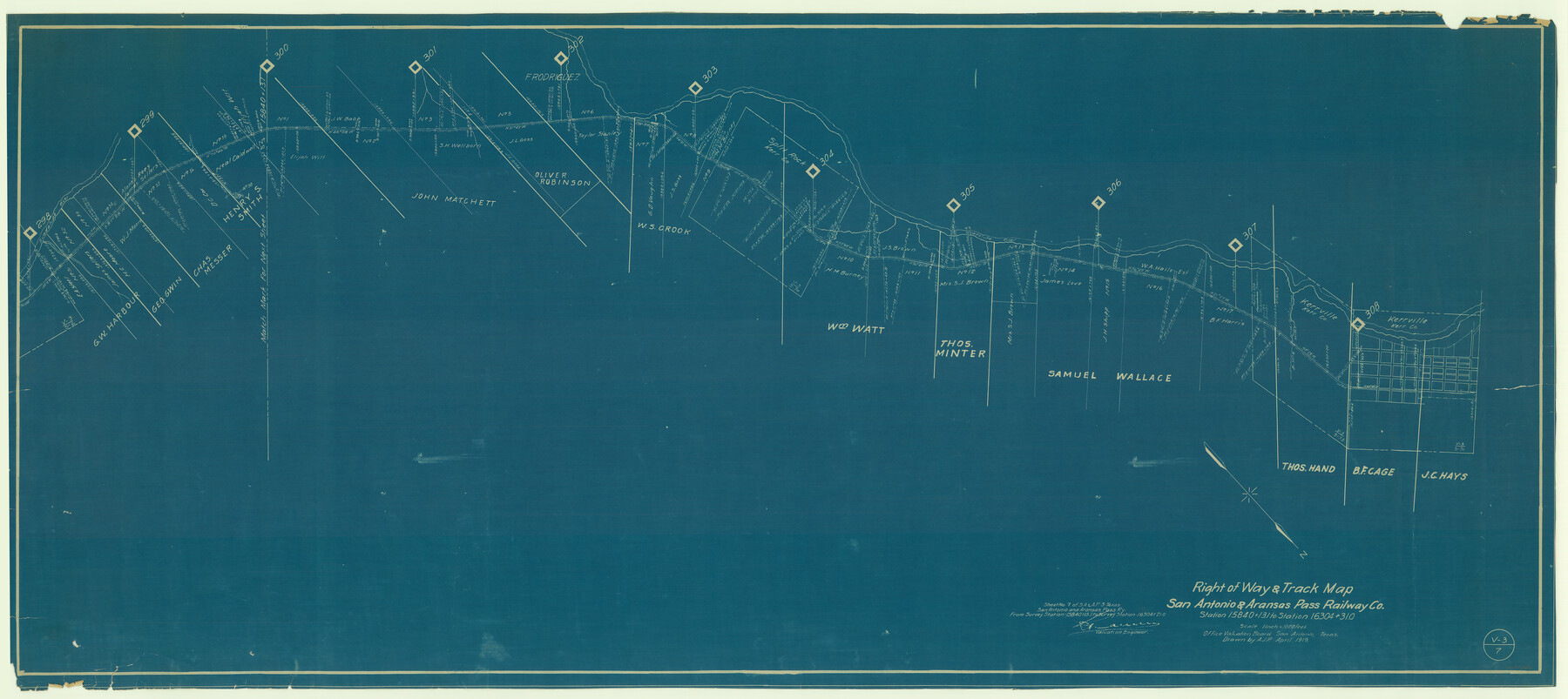
Right of Way & Track Map, San Antonio & Aransas Pass Railway Co.
Station 15840+13.1 to Station 16304+31.0
Z-2-54
-
Map/Doc
64214
-
Collection
General Map Collection
-
Object Dates
1919 (Creation Date)
-
People and Organizations
Office Valuation Board (Publisher)
-
Counties
Kerr
-
Subjects
Railroads
-
Height x Width
25.3 x 56.6 inches
64.3 x 143.8 cm
-
Medium
blueprint/diazo
-
Scale
1 inch = 1000 feet
-
Comments
See counters 64213 through 64218 for all pages of map.
-
Features
SA&AP
Guadalupe River
Kerrville
Part of: General Map Collection
Red River County Working Sketch 42

Print $20.00
- Digital $50.00
Red River County Working Sketch 42
1968
Size 28.7 x 36.8 inches
Map/Doc 72025
Montgomery County Working Sketch 49

Print $20.00
- Digital $50.00
Montgomery County Working Sketch 49
1959
Size 13.8 x 12.0 inches
Map/Doc 71156
Flight Mission No. BRE-2P, Frame 82, Nueces County

Print $20.00
- Digital $50.00
Flight Mission No. BRE-2P, Frame 82, Nueces County
1956
Size 18.5 x 22.6 inches
Map/Doc 86777
Rio Grande Rectification Project, El Paso and Juarez Valley

Print $20.00
- Digital $50.00
Rio Grande Rectification Project, El Paso and Juarez Valley
1935
Size 10.9 x 29.7 inches
Map/Doc 60860
Le Nouveau Mexique avec la partie Septentrionale de l'Ancien ou de la Nouvelle Espagne

Print $20.00
- Digital $50.00
Le Nouveau Mexique avec la partie Septentrionale de l'Ancien ou de la Nouvelle Espagne
1780
Size 10.0 x 14.4 inches
Map/Doc 97277
Oldham County Rolled Sketch 12

Print $20.00
- Digital $50.00
Oldham County Rolled Sketch 12
1981
Size 25.2 x 38.0 inches
Map/Doc 7177
Lynn County Rolled Sketch W

Print $20.00
- Digital $50.00
Lynn County Rolled Sketch W
Size 23.0 x 40.0 inches
Map/Doc 6655
Hemphill County Working Sketch 3

Print $40.00
- Digital $50.00
Hemphill County Working Sketch 3
1940
Size 51.8 x 27.4 inches
Map/Doc 66098
Aransas County NRC Article 33.136 Sketch 12

Print $44.00
- Digital $50.00
Aransas County NRC Article 33.136 Sketch 12
2012
Size 36.0 x 48.0 inches
Map/Doc 94510
Comanche County Sketch File 29

Print $23.00
- Digital $50.00
Comanche County Sketch File 29
1954
Size 13.4 x 10.2 inches
Map/Doc 19120

You may also like
Hockley County Sketch File 1

Print $20.00
- Digital $50.00
Hockley County Sketch File 1
Size 20.3 x 18.9 inches
Map/Doc 11767
Polk County Rolled Sketch 32

Print $20.00
- Digital $50.00
Polk County Rolled Sketch 32
Size 21.6 x 15.8 inches
Map/Doc 7318
Matagorda County Working Sketch 9

Print $20.00
- Digital $50.00
Matagorda County Working Sketch 9
1954
Size 26.5 x 22.3 inches
Map/Doc 70867
Right of Way and Track Map, Dayton-Goose Creek Ry. Co., Station 190+00 to Station 401+20

Print $40.00
- Digital $50.00
Right of Way and Track Map, Dayton-Goose Creek Ry. Co., Station 190+00 to Station 401+20
1917
Size 25.4 x 56.8 inches
Map/Doc 64366
Dimmit County Working Sketch 21

Print $20.00
- Digital $50.00
Dimmit County Working Sketch 21
1950
Size 35.1 x 18.8 inches
Map/Doc 68682
[F. W. & D. C. Ry. Co. Alignment and Right of Way Map, Clay County]
![64746, [F. W. & D. C. Ry. Co. Alignment and Right of Way Map, Clay County], General Map Collection](https://historictexasmaps.com/wmedia_w700/maps/64746-GC.tif.jpg)
Print $20.00
- Digital $50.00
[F. W. & D. C. Ry. Co. Alignment and Right of Way Map, Clay County]
1927
Size 18.7 x 11.9 inches
Map/Doc 64746
Hutchinson County Boundary File 1

Print $82.00
- Digital $50.00
Hutchinson County Boundary File 1
Size 8.7 x 38.3 inches
Map/Doc 55292
Nueces County Sketch File 16

Print $6.00
- Digital $50.00
Nueces County Sketch File 16
1875
Size 15.5 x 10.7 inches
Map/Doc 32547
Terrell County Working Sketch 2

Print $20.00
- Digital $50.00
Terrell County Working Sketch 2
1908
Size 19.8 x 24.2 inches
Map/Doc 62150
Concho County Sketch File 10

Print $20.00
- Digital $50.00
Concho County Sketch File 10
1887
Size 23.1 x 33.8 inches
Map/Doc 11150
Real County Working Sketch 22

Print $20.00
- Digital $50.00
Real County Working Sketch 22
1945
Size 20.0 x 21.7 inches
Map/Doc 71914
Brazoria County Working Sketch 47

Print $40.00
- Digital $50.00
Brazoria County Working Sketch 47
1988
Size 35.3 x 59.9 inches
Map/Doc 67532