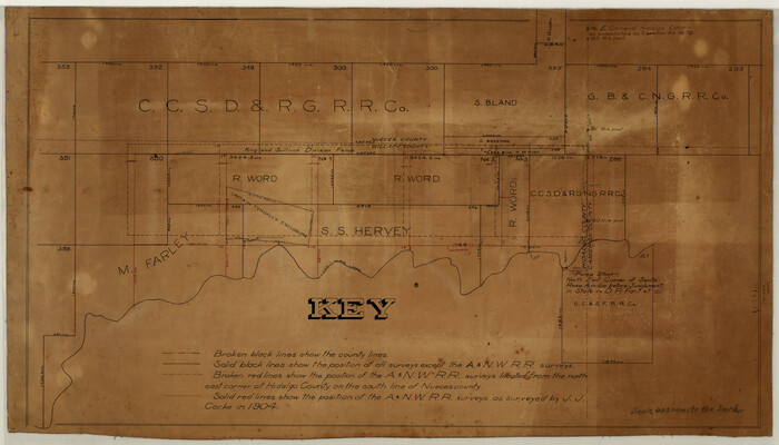
[Surveying Sketch of M. Farley, R. Word, S. S. Hervey, et al in Kleberg County, Texas]
Print $20.00
- Digital $50.00
[Surveying Sketch of M. Farley, R. Word, S. S. Hervey, et al in Kleberg County, Texas]
Size: 23.2 x 40.6 inches
10783
Texas Gulf Coast Map from the Sabine River to the Rio Grande as subdivided for mineral development

Print $40.00
- Digital $50.00
Texas Gulf Coast Map from the Sabine River to the Rio Grande as subdivided for mineral development
Size: 117.9 x 46.0 inches
2902
Nueces County Sketch File 28

Print $6.00
- Digital $50.00
Nueces County Sketch File 28
Size: 10.0 x 10.9 inches
32596
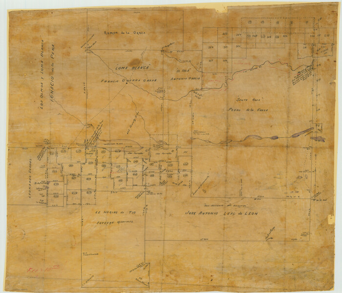
[Surveying Sketch of Loma Blanca, Santa Rosa, San Antonio del Encinal, et al]
Print $20.00
- Digital $50.00
[Surveying Sketch of Loma Blanca, Santa Rosa, San Antonio del Encinal, et al]
Size: 19.0 x 22.1 inches
4449
Starr County Sketch File 14

Print $40.00
- Digital $50.00
Starr County Sketch File 14
Size: 23.8 x 46.0 inches
4626
Padre Island National Seashore

Print $2.00
- Digital $50.00
Padre Island National Seashore
Size: 11.2 x 8.2 inches
60524
Padre Island National Seashore

Print $4.00
- Digital $50.00
Padre Island National Seashore
Size: 16.0 x 22.2 inches
60525
Padre Island National Seashore

Print $4.00
- Digital $50.00
Padre Island National Seashore
Size: 16.0 x 21.9 inches
60526
Padre Island National Seashore

Print $4.00
- Digital $50.00
Padre Island National Seashore
Size: 16.0 x 21.8 inches
60527
Padre Island National Seashore

Print $4.00
- Digital $50.00
Padre Island National Seashore
Size: 16.0 x 22.1 inches
60528
Kleberg County Boundary File 1

Print $10.00
- Digital $50.00
Kleberg County Boundary File 1
Size: 9.3 x 5.9 inches
64961
Kleberg County Boundary File 2

Print $22.00
- Digital $50.00
Kleberg County Boundary File 2
Size: 14.3 x 8.7 inches
64966
Kleberg County Boundary File 2a

Print $40.00
- Digital $50.00
Kleberg County Boundary File 2a
Size: 15.4 x 58.3 inches
64977
Kleberg County Boundary File 2b

Print $20.00
- Digital $50.00
Kleberg County Boundary File 2b
Size: 8.0 x 28.9 inches
64978
Kleberg County Boundary File 2c

Print $40.00
- Digital $50.00
Kleberg County Boundary File 2c
Size: 8.8 x 49.6 inches
64979
Kleberg County Boundary File 2d

Print $20.00
- Digital $50.00
Kleberg County Boundary File 2d
Size: 9.1 x 34.6 inches
64980
Kleberg County Boundary File 3

Print $10.00
- Digital $50.00
Kleberg County Boundary File 3
Size: 9.5 x 6.1 inches
64981
Kleberg County Boundary File 4

Print $22.00
- Digital $50.00
Kleberg County Boundary File 4
Size: 14.2 x 8.6 inches
64986
Kleberg County Boundary File 4a

Print $40.00
- Digital $50.00
Kleberg County Boundary File 4a
Size: 23.3 x 62.2 inches
64997
Kleberg County Rolled Sketch 5

Print $20.00
- Digital $50.00
Kleberg County Rolled Sketch 5
Size: 27.8 x 21.8 inches
6548
Kleberg County Rolled Sketch 5A

Print $20.00
- Digital $50.00
Kleberg County Rolled Sketch 5A
Size: 31.0 x 25.1 inches
6549
Sketch for Mineral Application 33721 - 33725 Incl (Attorney General) - Map of Padre Island - Cameron, Willacy, Kleberg, Nueces and Kenedy Counties.

Print $20.00
- Digital $50.00
Sketch for Mineral Application 33721 - 33725 Incl (Attorney General) - Map of Padre Island - Cameron, Willacy, Kleberg, Nueces and Kenedy Counties.
Size: 43.3 x 23.1 inches
65663
[Sketch for Mineral Application 33721 - 33725 Incl. - Padre and Mustang Island]
Print $20.00
- Digital $50.00
[Sketch for Mineral Application 33721 - 33725 Incl. - Padre and Mustang Island]
Size: 42.3 x 22.6 inches
65664
Jim Wells County Working Sketch 1

Print $20.00
- Digital $50.00
Jim Wells County Working Sketch 1
Size: 17.2 x 22.2 inches
66599
Brooks County Working Sketch 3

Print $20.00
- Digital $50.00
Brooks County Working Sketch 3
Size: 16.2 x 21.3 inches
67787
Kenedy County Working Sketch 1

Print $20.00
- Digital $50.00
Kenedy County Working Sketch 1
Size: 31.1 x 22.0 inches
70002
Texas Intracoastal Waterway - Laguna Madre - Dagger Hill to Potrero Grande

Print $20.00
- Digital $50.00
Texas Intracoastal Waterway - Laguna Madre - Dagger Hill to Potrero Grande
Size: 39.0 x 27.3 inches
73508

Map Showing Position of Surveys Represented Hereon

Print $40.00
- Digital $50.00
Map Showing Position of Surveys Represented Hereon
Size: 38.9 x 57.2 inches
75809
Map Showing Position of Surveys Represented Hereon

Print $40.00
- Digital $50.00
Map Showing Position of Surveys Represented Hereon
Size: 39.6 x 57.9 inches
75810
[Surveying Sketch of M. Farley, R. Word, S. S. Hervey, et al in Kleberg County, Texas]
Print $20.00
- Digital $50.00
[Surveying Sketch of M. Farley, R. Word, S. S. Hervey, et al in Kleberg County, Texas]
-
Size
23.2 x 40.6 inches
-
Map/Doc
10783
Texas Gulf Coast Map from the Sabine River to the Rio Grande as subdivided for mineral development
Print $40.00
- Digital $50.00
Texas Gulf Coast Map from the Sabine River to the Rio Grande as subdivided for mineral development
-
Size
117.9 x 46.0 inches
-
Map/Doc
2902
Nueces County Sketch File 28
Print $6.00
- Digital $50.00
Nueces County Sketch File 28
-
Size
10.0 x 10.9 inches
-
Map/Doc
32596
[Surveying Sketch of Loma Blanca, Santa Rosa, San Antonio del Encinal, et al]
Print $20.00
- Digital $50.00
[Surveying Sketch of Loma Blanca, Santa Rosa, San Antonio del Encinal, et al]
-
Size
19.0 x 22.1 inches
-
Map/Doc
4449
Starr County Sketch File 14
Print $40.00
- Digital $50.00
Starr County Sketch File 14
-
Size
23.8 x 46.0 inches
-
Map/Doc
4626
Padre Island National Seashore
Print $2.00
- Digital $50.00
Padre Island National Seashore
-
Size
11.2 x 8.2 inches
-
Map/Doc
60524
Padre Island National Seashore
Print $4.00
- Digital $50.00
Padre Island National Seashore
-
Size
16.0 x 22.2 inches
-
Map/Doc
60525
Padre Island National Seashore
Print $4.00
- Digital $50.00
Padre Island National Seashore
-
Size
16.0 x 21.9 inches
-
Map/Doc
60526
Padre Island National Seashore
Print $4.00
- Digital $50.00
Padre Island National Seashore
-
Size
16.0 x 21.8 inches
-
Map/Doc
60527
Padre Island National Seashore
Print $4.00
- Digital $50.00
Padre Island National Seashore
-
Size
16.0 x 22.1 inches
-
Map/Doc
60528
Kleberg County Boundary File 1
Print $10.00
- Digital $50.00
Kleberg County Boundary File 1
-
Size
9.3 x 5.9 inches
-
Map/Doc
64961
Kleberg County Boundary File 2
Print $22.00
- Digital $50.00
Kleberg County Boundary File 2
-
Size
14.3 x 8.7 inches
-
Map/Doc
64966
Kleberg County Boundary File 2a
Print $40.00
- Digital $50.00
Kleberg County Boundary File 2a
-
Size
15.4 x 58.3 inches
-
Map/Doc
64977
Kleberg County Boundary File 2b
Print $20.00
- Digital $50.00
Kleberg County Boundary File 2b
-
Size
8.0 x 28.9 inches
-
Map/Doc
64978
Kleberg County Boundary File 2c
Print $40.00
- Digital $50.00
Kleberg County Boundary File 2c
-
Size
8.8 x 49.6 inches
-
Map/Doc
64979
Kleberg County Boundary File 2d
Print $20.00
- Digital $50.00
Kleberg County Boundary File 2d
-
Size
9.1 x 34.6 inches
-
Map/Doc
64980
Kleberg County Boundary File 3
Print $10.00
- Digital $50.00
Kleberg County Boundary File 3
-
Size
9.5 x 6.1 inches
-
Map/Doc
64981
Kleberg County Boundary File 4
Print $22.00
- Digital $50.00
Kleberg County Boundary File 4
-
Size
14.2 x 8.6 inches
-
Map/Doc
64986
Kleberg County Boundary File 4a
Print $40.00
- Digital $50.00
Kleberg County Boundary File 4a
-
Size
23.3 x 62.2 inches
-
Map/Doc
64997
Kleberg County Rolled Sketch 5
Print $20.00
- Digital $50.00
Kleberg County Rolled Sketch 5
-
Size
27.8 x 21.8 inches
-
Map/Doc
6548
Kleberg County Rolled Sketch 5A
Print $20.00
- Digital $50.00
Kleberg County Rolled Sketch 5A
-
Size
31.0 x 25.1 inches
-
Map/Doc
6549
Sketch for Mineral Application 33721 - 33725 Incl (Attorney General) - Map of Padre Island - Cameron, Willacy, Kleberg, Nueces and Kenedy Counties.
Print $20.00
- Digital $50.00
Sketch for Mineral Application 33721 - 33725 Incl (Attorney General) - Map of Padre Island - Cameron, Willacy, Kleberg, Nueces and Kenedy Counties.
-
Size
43.3 x 23.1 inches
-
Map/Doc
65663
[Sketch for Mineral Application 33721 - 33725 Incl. - Padre and Mustang Island]
Print $20.00
- Digital $50.00
[Sketch for Mineral Application 33721 - 33725 Incl. - Padre and Mustang Island]
-
Size
42.3 x 22.6 inches
-
Map/Doc
65664
Jim Wells County Working Sketch 1
Print $20.00
- Digital $50.00
Jim Wells County Working Sketch 1
-
Size
17.2 x 22.2 inches
-
Map/Doc
66599
Brooks County Working Sketch 3
Print $20.00
- Digital $50.00
Brooks County Working Sketch 3
-
Size
16.2 x 21.3 inches
-
Map/Doc
67787
Kenedy County Working Sketch 1
Print $20.00
- Digital $50.00
Kenedy County Working Sketch 1
-
Size
31.1 x 22.0 inches
-
Map/Doc
70002
Texas Intracoastal Waterway - Laguna Madre - Dagger Hill to Potrero Grande
Print $20.00
- Digital $50.00
Texas Intracoastal Waterway - Laguna Madre - Dagger Hill to Potrero Grande
-
Size
39.0 x 27.3 inches
-
Map/Doc
73508
Map Showing Position of Surveys Represented Hereon
Print $40.00
- Digital $50.00
Map Showing Position of Surveys Represented Hereon
-
Size
38.9 x 57.2 inches
-
Map/Doc
75809
Map Showing Position of Surveys Represented Hereon
Print $40.00
- Digital $50.00
Map Showing Position of Surveys Represented Hereon
-
Size
39.6 x 57.9 inches
-
Map/Doc
75810