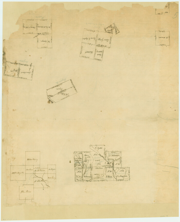
[Surveys along the Red River, Bois d'Arc Creek, Duck Creek, and Choctaw Bayou made under G.W. Smyth, Commissioner]
Print $20.00
- Digital $50.00
[Surveys along the Red River, Bois d'Arc Creek, Duck Creek, and Choctaw Bayou made under G.W. Smyth, Commissioner]
1834
Size: 19.7 x 16.0 inches
74
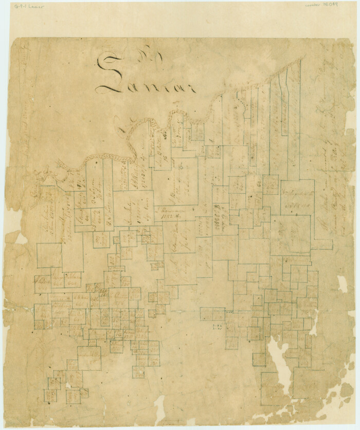
[Surveys along and below the Red River and the Lamar and Fannin County line, Lamar District]
Print $3.00
- Digital $50.00
[Surveys along and below the Red River and the Lamar and Fannin County line, Lamar District]
Size: 12.1 x 10.1 inches
76049
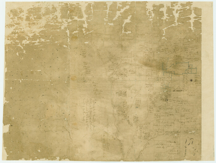
[South part of Lamar County]
Print $20.00
- Digital $50.00
[South part of Lamar County]
1844
Size: 15.5 x 20.5 inches
76045
Water-Shed of the Sulphur River in Texas Drainage Area

Print $4.00
- Digital $50.00
Water-Shed of the Sulphur River in Texas Drainage Area
1925
Size: 16.6 x 28.4 inches
65154
University Land, Lamar County

Print $20.00
- Digital $50.00
University Land, Lamar County
1906
Size: 23.8 x 29.9 inches
2431
The Republic County of Lamar. Spring 1842

Print $20.00
The Republic County of Lamar. Spring 1842
2020
Size: 16.4 x 21.7 inches
96204
The Republic County of Lamar. January 3, 1844

Print $20.00
The Republic County of Lamar. January 3, 1844
2020
Size: 16.4 x 21.7 inches
96206
The Republic County of Lamar. January 28, 1841

Print $20.00
The Republic County of Lamar. January 28, 1841
2020
Size: 16.4 x 21.7 inches
96203
The Republic County of Lamar. December 29, 1845

Print $20.00
The Republic County of Lamar. December 29, 1845
2020
Size: 16.4 x 21.7 inches
96207
The Republic County of Lamar. December 26, 1842

Print $20.00
The Republic County of Lamar. December 26, 1842
2020
Size: 16.4 x 21.7 inches
96205
The Republic County of Lamar. Created, December 17, 1840

Print $20.00
The Republic County of Lamar. Created, December 17, 1840
2020
Size: 16.4 x 21.7 inches
96202
Sulphur River, Ringo Crossing Sheet

Print $20.00
- Digital $50.00
Sulphur River, Ringo Crossing Sheet
1933
Size: 30.5 x 35.9 inches
65162
Sulphur River, Ringo Crossing Sheet

Print $20.00
- Digital $50.00
Sulphur River, Ringo Crossing Sheet
1933
Size: 18.5 x 20.4 inches
78334
Red River, Levee Improvement Districts Widths of Floodways - Bois D'Arc Creek

Print $20.00
- Digital $50.00
Red River, Levee Improvement Districts Widths of Floodways - Bois D'Arc Creek
1921
Size: 29.5 x 26.0 inches
65271
Red River County Sketch File 8b

Print $6.00
- Digital $50.00
Red River County Sketch File 8b
1860
Size: 8.2 x 3.7 inches
35114
Red River County Sketch File 8

Print $22.00
- Digital $50.00
Red River County Sketch File 8
Size: 14.7 x 16.8 inches
35112
Red River County Sketch File 19

Print $4.00
- Digital $50.00
Red River County Sketch File 19
Size: 8.1 x 12.7 inches
35150
Red River County Sketch File 10

Print $15.00
- Digital $50.00
Red River County Sketch File 10
1863
Size: 9.1 x 7.4 inches
35121
Red River County Rolled Sketch 7A

Print $20.00
- Digital $50.00
Red River County Rolled Sketch 7A
Size: 28.3 x 33.1 inches
7472
Paris, Texas, County Seat of Lamar County

Print $20.00
Paris, Texas, County Seat of Lamar County
1885
Size: 17.8 x 23.8 inches
89201
North and South Sulphur Rivers, Sulphur Bluff Sheet

Print $20.00
- Digital $50.00
North and South Sulphur Rivers, Sulphur Bluff Sheet
1933
Size: 37.6 x 37.2 inches
65163
North Sulphur River, Sims Crossing Sheet

Print $20.00
- Digital $50.00
North Sulphur River, Sims Crossing Sheet
1924
Size: 23.4 x 39.9 inches
65167
North Sulphur River, Sims Crossing Sheet

Print $20.00
- Digital $50.00
North Sulphur River, Sims Crossing Sheet
1924
Size: 12.4 x 25.1 inches
78335
North Sulphur River, Mt. Joy Sheet

Print $20.00
- Digital $50.00
North Sulphur River, Mt. Joy Sheet
1926
Size: 33.7 x 40.9 inches
65166
North Sulphur River, Mt. Joy Sheet

Print $20.00
- Digital $50.00
North Sulphur River, Mt. Joy Sheet
1926
Size: 18.4 x 21.6 inches
78333
North Sulphur River, Kinsing Sheet

Print $20.00
- Digital $50.00
North Sulphur River, Kinsing Sheet
1925
Size: 30.5 x 40.8 inches
65165
North Sulphur River, Kinsing Sheet

Print $20.00
- Digital $50.00
North Sulphur River, Kinsing Sheet
1925
Size: 18.6 x 23.4 inches
78331
North Sulphur River, Ben Franklin Sheet

Print $40.00
- Digital $50.00
North Sulphur River, Ben Franklin Sheet
1928
Size: 24.6 x 57.4 inches
65172
North Sulphur River, Ben Franklin Sheet

Print $20.00
- Digital $50.00
North Sulphur River, Ben Franklin Sheet
1928
Size: 14.2 x 30.0 inches
78324
North East Corner of Lamar County

Print $3.00
- Digital $50.00
North East Corner of Lamar County
Size: 10.7 x 15.4 inches
291
[Surveys along the Red River, Bois d'Arc Creek, Duck Creek, and Choctaw Bayou made under G.W. Smyth, Commissioner]
Print $20.00
- Digital $50.00
[Surveys along the Red River, Bois d'Arc Creek, Duck Creek, and Choctaw Bayou made under G.W. Smyth, Commissioner]
1834
-
Size
19.7 x 16.0 inches
-
Map/Doc
74
-
Creation Date
1834
[Surveys along and below the Red River and the Lamar and Fannin County line, Lamar District]
Print $3.00
- Digital $50.00
[Surveys along and below the Red River and the Lamar and Fannin County line, Lamar District]
-
Size
12.1 x 10.1 inches
-
Map/Doc
76049
[South part of Lamar County]
Print $20.00
- Digital $50.00
[South part of Lamar County]
1844
-
Size
15.5 x 20.5 inches
-
Map/Doc
76045
-
Creation Date
1844
Water-Shed of the Sulphur River in Texas Drainage Area
Print $4.00
- Digital $50.00
Water-Shed of the Sulphur River in Texas Drainage Area
1925
-
Size
16.6 x 28.4 inches
-
Map/Doc
65154
-
Creation Date
1925
University Land, Lamar County
Print $20.00
- Digital $50.00
University Land, Lamar County
1906
-
Size
23.8 x 29.9 inches
-
Map/Doc
2431
-
Creation Date
1906
The Republic County of Lamar. Spring 1842
Print $20.00
The Republic County of Lamar. Spring 1842
2020
-
Size
16.4 x 21.7 inches
-
Map/Doc
96204
-
Creation Date
2020
The Republic County of Lamar. January 3, 1844
Print $20.00
The Republic County of Lamar. January 3, 1844
2020
-
Size
16.4 x 21.7 inches
-
Map/Doc
96206
-
Creation Date
2020
The Republic County of Lamar. January 28, 1841
Print $20.00
The Republic County of Lamar. January 28, 1841
2020
-
Size
16.4 x 21.7 inches
-
Map/Doc
96203
-
Creation Date
2020
The Republic County of Lamar. December 29, 1845
Print $20.00
The Republic County of Lamar. December 29, 1845
2020
-
Size
16.4 x 21.7 inches
-
Map/Doc
96207
-
Creation Date
2020
The Republic County of Lamar. December 26, 1842
Print $20.00
The Republic County of Lamar. December 26, 1842
2020
-
Size
16.4 x 21.7 inches
-
Map/Doc
96205
-
Creation Date
2020
The Republic County of Lamar. Created, December 17, 1840
Print $20.00
The Republic County of Lamar. Created, December 17, 1840
2020
-
Size
16.4 x 21.7 inches
-
Map/Doc
96202
-
Creation Date
2020
Sulphur River, Ringo Crossing Sheet
Print $20.00
- Digital $50.00
Sulphur River, Ringo Crossing Sheet
1933
-
Size
30.5 x 35.9 inches
-
Map/Doc
65162
-
Creation Date
1933
Sulphur River, Ringo Crossing Sheet
Print $20.00
- Digital $50.00
Sulphur River, Ringo Crossing Sheet
1933
-
Size
18.5 x 20.4 inches
-
Map/Doc
78334
-
Creation Date
1933
Red River, Levee Improvement Districts Widths of Floodways - Bois D'Arc Creek
Print $20.00
- Digital $50.00
Red River, Levee Improvement Districts Widths of Floodways - Bois D'Arc Creek
1921
-
Size
29.5 x 26.0 inches
-
Map/Doc
65271
-
Creation Date
1921
Red River County Sketch File 8b
Print $6.00
- Digital $50.00
Red River County Sketch File 8b
1860
-
Size
8.2 x 3.7 inches
-
Map/Doc
35114
-
Creation Date
1860
Red River County Sketch File 8
Print $22.00
- Digital $50.00
Red River County Sketch File 8
-
Size
14.7 x 16.8 inches
-
Map/Doc
35112
Red River County Sketch File 19
Print $4.00
- Digital $50.00
Red River County Sketch File 19
-
Size
8.1 x 12.7 inches
-
Map/Doc
35150
Red River County Sketch File 10
Print $15.00
- Digital $50.00
Red River County Sketch File 10
1863
-
Size
9.1 x 7.4 inches
-
Map/Doc
35121
-
Creation Date
1863
Red River County Rolled Sketch 7A
Print $20.00
- Digital $50.00
Red River County Rolled Sketch 7A
-
Size
28.3 x 33.1 inches
-
Map/Doc
7472
Paris, Texas, County Seat of Lamar County
Print $20.00
Paris, Texas, County Seat of Lamar County
1885
-
Size
17.8 x 23.8 inches
-
Map/Doc
89201
-
Creation Date
1885
North and South Sulphur Rivers, Sulphur Bluff Sheet
Print $20.00
- Digital $50.00
North and South Sulphur Rivers, Sulphur Bluff Sheet
1933
-
Size
37.6 x 37.2 inches
-
Map/Doc
65163
-
Creation Date
1933
North Sulphur River, Sims Crossing Sheet
Print $20.00
- Digital $50.00
North Sulphur River, Sims Crossing Sheet
1924
-
Size
23.4 x 39.9 inches
-
Map/Doc
65167
-
Creation Date
1924
North Sulphur River, Sims Crossing Sheet
Print $20.00
- Digital $50.00
North Sulphur River, Sims Crossing Sheet
1924
-
Size
12.4 x 25.1 inches
-
Map/Doc
78335
-
Creation Date
1924
North Sulphur River, Mt. Joy Sheet
Print $20.00
- Digital $50.00
North Sulphur River, Mt. Joy Sheet
1926
-
Size
33.7 x 40.9 inches
-
Map/Doc
65166
-
Creation Date
1926
North Sulphur River, Mt. Joy Sheet
Print $20.00
- Digital $50.00
North Sulphur River, Mt. Joy Sheet
1926
-
Size
18.4 x 21.6 inches
-
Map/Doc
78333
-
Creation Date
1926
North Sulphur River, Kinsing Sheet
Print $20.00
- Digital $50.00
North Sulphur River, Kinsing Sheet
1925
-
Size
30.5 x 40.8 inches
-
Map/Doc
65165
-
Creation Date
1925
North Sulphur River, Kinsing Sheet
Print $20.00
- Digital $50.00
North Sulphur River, Kinsing Sheet
1925
-
Size
18.6 x 23.4 inches
-
Map/Doc
78331
-
Creation Date
1925
North Sulphur River, Ben Franklin Sheet
Print $40.00
- Digital $50.00
North Sulphur River, Ben Franklin Sheet
1928
-
Size
24.6 x 57.4 inches
-
Map/Doc
65172
-
Creation Date
1928
North Sulphur River, Ben Franklin Sheet
Print $20.00
- Digital $50.00
North Sulphur River, Ben Franklin Sheet
1928
-
Size
14.2 x 30.0 inches
-
Map/Doc
78324
-
Creation Date
1928
North East Corner of Lamar County
Print $3.00
- Digital $50.00
North East Corner of Lamar County
-
Size
10.7 x 15.4 inches
-
Map/Doc
291