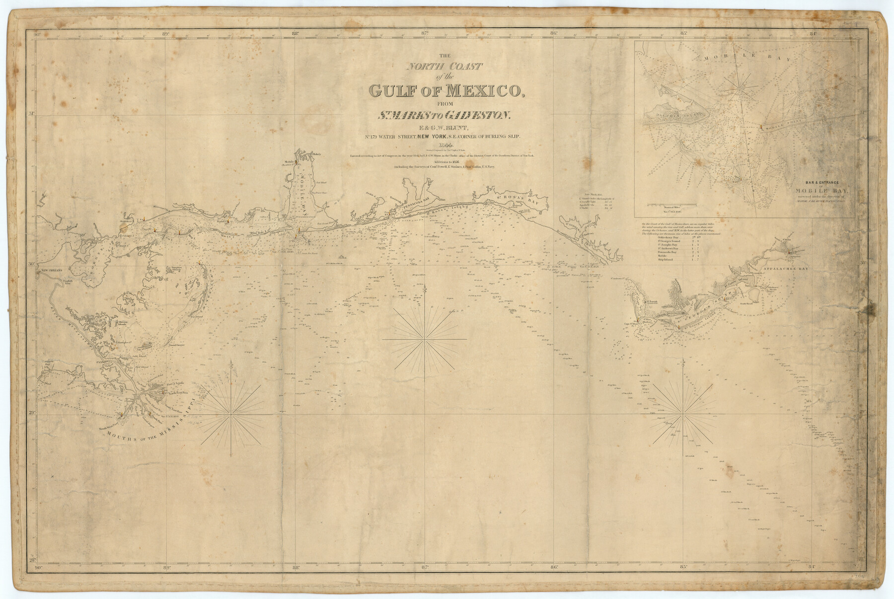
The North Coast of the Gulf of Mexico from St. Marks to Galveston
-
Map/Doc
97396
-
Collection
General Map Collection
-
Object Dates
1844 (Creation Date)
1856 (Revision Date)
-
People and Organizations
E. Blunt (Cartographer)
G.W. Blunt (Cartographer)
Charles Copley (Draftsman)
-
Subjects
Gulf of Mexico Nautical Charts
-
Height x Width
27.5 x 41.1 inches
69.9 x 104.4 cm
-
Comments
Sheet 1 of 2. See 97397 for Sheet 2.
Related maps
St. Marks to Galveston - Sheet II

Print $20.00
- Digital $50.00
St. Marks to Galveston - Sheet II
1846
Size 26.5 x 40.5 inches
Map/Doc 97397
Part of: General Map Collection
Burnet County Rolled Sketch 3

Print $20.00
- Digital $50.00
Burnet County Rolled Sketch 3
Size 23.7 x 26.2 inches
Map/Doc 5355
Liberty County Working Sketch 46

Print $20.00
- Digital $50.00
Liberty County Working Sketch 46
1953
Size 18.6 x 37.6 inches
Map/Doc 70505
Midland County Working Sketch 25

Print $40.00
- Digital $50.00
Midland County Working Sketch 25
1957
Size 58.3 x 49.1 inches
Map/Doc 71006
Houston County Sketch File 34

Print $6.00
- Digital $50.00
Houston County Sketch File 34
1914
Size 13.3 x 11.0 inches
Map/Doc 26811
Flight Mission No. DAG-14K, Frame 41, Matagorda County

Print $20.00
- Digital $50.00
Flight Mission No. DAG-14K, Frame 41, Matagorda County
1952
Size 18.6 x 22.4 inches
Map/Doc 86299
Webb County Rolled Sketch 70

Print $20.00
- Digital $50.00
Webb County Rolled Sketch 70
Size 24.0 x 37.4 inches
Map/Doc 8217
Cooke County Sketch File 19

Print $8.00
- Digital $50.00
Cooke County Sketch File 19
1861
Size 7.9 x 6.1 inches
Map/Doc 19260
Lampasas County Working Sketch 5

Print $20.00
- Digital $50.00
Lampasas County Working Sketch 5
1947
Size 25.6 x 31.8 inches
Map/Doc 70282
Outer Continental Shelf Leasing Maps (Texas Offshore Operations)

Print $20.00
- Digital $50.00
Outer Continental Shelf Leasing Maps (Texas Offshore Operations)
Size 12.7 x 15.2 inches
Map/Doc 76169
Marion County Working Sketch 21

Print $20.00
- Digital $50.00
Marion County Working Sketch 21
1958
Size 29.1 x 26.9 inches
Map/Doc 70797
Loving County Working Sketch 11

Print $40.00
- Digital $50.00
Loving County Working Sketch 11
1957
Size 21.2 x 120.7 inches
Map/Doc 70643
Culberson County Rolled Sketch 42

Print $20.00
- Digital $50.00
Culberson County Rolled Sketch 42
Size 23.0 x 29.0 inches
Map/Doc 5663
You may also like
Travis County Rolled Sketch 40

Print $407.00
- Digital $50.00
Travis County Rolled Sketch 40
1953
Size 10.4 x 15.4 inches
Map/Doc 49195
Goliad County Sketch File 20

Print $38.00
- Digital $50.00
Goliad County Sketch File 20
1887
Size 8.8 x 12.3 inches
Map/Doc 24265
Map representing the surveys made in Bexar County

Print $40.00
- Digital $50.00
Map representing the surveys made in Bexar County
1839
Size 75.7 x 35.1 inches
Map/Doc 93365
Railroad Track Map, H&TCRRCo., Falls County, Texas

Print $4.00
- Digital $50.00
Railroad Track Map, H&TCRRCo., Falls County, Texas
1918
Size 11.3 x 18.5 inches
Map/Doc 62847
Shelby County Sketch File 7

Print $4.00
- Digital $50.00
Shelby County Sketch File 7
1855
Size 8.9 x 13.3 inches
Map/Doc 36605
[Townships 1 & 2, Blocks 53, 54 & 55]
![92952, [Townships 1 & 2, Blocks 53, 54 & 55], Twichell Survey Records](https://historictexasmaps.com/wmedia_w700/maps/92952-1.tif.jpg)
Print $20.00
- Digital $50.00
[Townships 1 & 2, Blocks 53, 54 & 55]
Size 34.3 x 20.0 inches
Map/Doc 92952
Right of Way and Track Map Houston & Texas Central R.R. operated by the T. and N. O. R.R. Co., Fort Worth Branch

Print $40.00
- Digital $50.00
Right of Way and Track Map Houston & Texas Central R.R. operated by the T. and N. O. R.R. Co., Fort Worth Branch
1918
Size 31.1 x 57.3 inches
Map/Doc 64543
Flight Mission No. DCL-7C, Frame 70, Kenedy County

Print $20.00
- Digital $50.00
Flight Mission No. DCL-7C, Frame 70, Kenedy County
1943
Size 15.4 x 15.3 inches
Map/Doc 86056
Tom Green County Rolled Sketch 3

Print $20.00
- Digital $50.00
Tom Green County Rolled Sketch 3
Size 26.8 x 32.8 inches
Map/Doc 7993
Map of Defunct and Ghost Counties in Texas

Print $20.00
- Digital $50.00
Map of Defunct and Ghost Counties in Texas
1939
Size 35.0 x 35.9 inches
Map/Doc 2148
Wood County Working Sketch 15

Print $20.00
- Digital $50.00
Wood County Working Sketch 15
Size 25.7 x 31.7 inches
Map/Doc 62015
Karnes County Sketch File 12

Print $14.00
- Digital $50.00
Karnes County Sketch File 12
1889
Size 12.7 x 8.0 inches
Map/Doc 28604