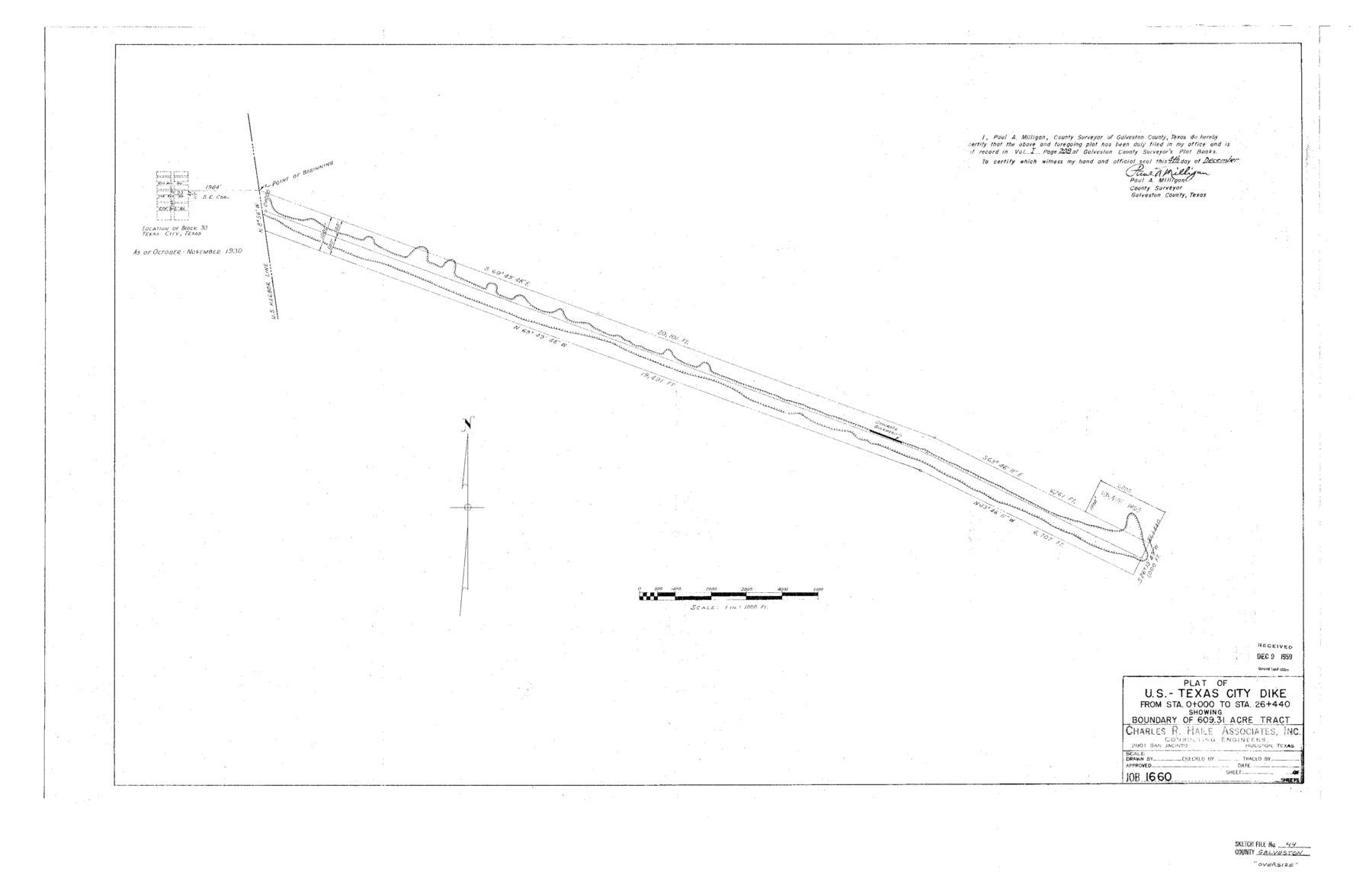
Galveston County Sketch File 44
Plat of U.S.-Texas City Dike From Sta. 0+000 to Sta. 26+440 showing boundary of 609.31 Acre Tract
-
Map/Doc
10456
-
Collection
General Map Collection
-
Object Dates
1959/12/4 (Creation Date)
1959/12/9 (File Date)
1930 (Survey Date)
-
People and Organizations
Charles R. Hale (Surveyor/Engineer)
-
Counties
Galveston
-
Subjects
Surveying Sketch File
-
Height x Width
25.2 x 38.8 inches
64.0 x 98.6 cm
-
Medium
paper, photocopy
-
Scale
1" = 1000 feet
-
Features
Texas City
6th Avenue North
7th Avenue North
8th Avenue North
Part of: General Map Collection
Jack County Working Sketch 10

Print $20.00
- Digital $50.00
Jack County Working Sketch 10
1955
Size 24.4 x 18.6 inches
Map/Doc 66436
Orange County Sketch File 27

Print $20.00
- Digital $50.00
Orange County Sketch File 27
1915
Size 18.6 x 21.8 inches
Map/Doc 12123

Edwards County Working Sketch 18

Print $20.00
- Digital $50.00
Edwards County Working Sketch 18
1931
Size 34.3 x 37.0 inches
Map/Doc 68894
[Surveys along the San Fernando and Santa Gertrudis, San Patricio District]
![290, [Surveys along the San Fernando and Santa Gertrudis, San Patricio District], General Map Collection](https://historictexasmaps.com/wmedia_w700/maps/290.tif.jpg)
Print $20.00
- Digital $50.00
[Surveys along the San Fernando and Santa Gertrudis, San Patricio District]
1847
Size 13.2 x 16.4 inches
Map/Doc 290
Culberson County Working Sketch 75

Print $40.00
- Digital $50.00
Culberson County Working Sketch 75
1975
Size 48.1 x 32.8 inches
Map/Doc 68529
United States - Gulf Coast - Galveston to Rio Grande

Print $20.00
- Digital $50.00
United States - Gulf Coast - Galveston to Rio Grande
1940
Size 27.1 x 18.2 inches
Map/Doc 72758
Briscoe County Sketch File 13

Print $168.00
- Digital $50.00
Briscoe County Sketch File 13
1982
Size 11.2 x 8.7 inches
Map/Doc 16428
Flight Mission No. DCL-7C, Frame 54, Kenedy County

Print $20.00
- Digital $50.00
Flight Mission No. DCL-7C, Frame 54, Kenedy County
1943
Size 15.3 x 15.3 inches
Map/Doc 86042
Sutton County Rolled Sketch 49

Print $20.00
- Digital $50.00
Sutton County Rolled Sketch 49
1947
Size 19.2 x 19.3 inches
Map/Doc 7890
Harris County

Print $40.00
- Digital $50.00
Harris County
1896
Size 44.4 x 69.3 inches
Map/Doc 66857
Van Zandt County Sketch File 47a

Print $7.00
- Digital $50.00
Van Zandt County Sketch File 47a
1875
Size 10.0 x 8.2 inches
Map/Doc 39507
You may also like
Tyler County Sketch File 28

Print $46.00
- Digital $50.00
Tyler County Sketch File 28
1960
Size 9.8 x 8.6 inches
Map/Doc 38699
Webb County Rolled Sketch 41

Print $20.00
- Digital $50.00
Webb County Rolled Sketch 41
1941
Size 25.0 x 18.0 inches
Map/Doc 8196
Bastrop County Working Sketch 9

Print $20.00
- Digital $50.00
Bastrop County Working Sketch 9
1981
Size 44.9 x 43.7 inches
Map/Doc 67309
Grayson County Sketch File 28

Print $4.00
- Digital $50.00
Grayson County Sketch File 28
1990
Size 14.3 x 8.8 inches
Map/Doc 24517
Dawson County Boundary File 1

Print $48.00
- Digital $50.00
Dawson County Boundary File 1
Size 8.8 x 4.0 inches
Map/Doc 52314
Runnels County Working Sketch 19

Print $20.00
- Digital $50.00
Runnels County Working Sketch 19
1950
Size 24.9 x 30.8 inches
Map/Doc 63615
Crockett County Rolled Sketch 7

Print $20.00
- Digital $50.00
Crockett County Rolled Sketch 7
Size 18.7 x 14.6 inches
Map/Doc 5580
Gaines County Working Sketch 30

Print $20.00
- Digital $50.00
Gaines County Working Sketch 30
1990
Size 18.3 x 26.4 inches
Map/Doc 69330
Hardin County Sketch File 5

Print $5.00
- Digital $50.00
Hardin County Sketch File 5
1856
Size 9.0 x 6.6 inches
Map/Doc 25092
Coryell County Boundary File 3

Print $14.00
- Digital $50.00
Coryell County Boundary File 3
Size 13.2 x 8.2 inches
Map/Doc 51907
Stonewall County Working Sketch 10

Print $20.00
- Digital $50.00
Stonewall County Working Sketch 10
1950
Size 16.8 x 22.8 inches
Map/Doc 62317
Working Sketch Carson County

Print $3.00
- Digital $50.00
Working Sketch Carson County
1907
Size 11.6 x 17.8 inches
Map/Doc 90224