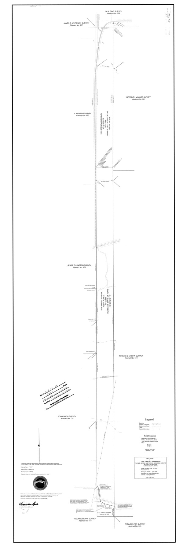
Rusk County Rolled Sketch 15
Plat of survey of 148.99 acres of land known as the M.D. Bryant and the H.H. Groneman surveys MF-22883 and MF-22884 in Rusk County, Texas
-
Map/Doc
10636
-
Collection
General Map Collection
-
Object Dates
2000 (Survey Date)
2000/11/16 (File Date)
2000/9/6 (Creation Date)
-
People and Organizations
Chris Valle (Draftsman)
Elisandro Leos (Surveyor/Engineer)
-
Counties
Rusk
-
Subjects
Surveying Rolled Sketch
-
Height x Width
62.4 x 21.2 inches
158.5 x 53.8 cm
-
Medium
mylar, print
-
Scale
1" = 90 varas
Part of: General Map Collection
Hood County Working Sketch 31

Print $20.00
- Digital $50.00
Hood County Working Sketch 31
1998
Size 33.6 x 35.8 inches
Map/Doc 66225
Ward County Working Sketch 52

Print $20.00
- Digital $50.00
Ward County Working Sketch 52
1980
Size 36.3 x 37.0 inches
Map/Doc 72358
Hood County Sketch File 22a

Print $5.00
- Digital $50.00
Hood County Sketch File 22a
Size 13.7 x 9.3 inches
Map/Doc 26617
Flight Mission No. CRC-4R, Frame 179, Chambers County

Print $20.00
- Digital $50.00
Flight Mission No. CRC-4R, Frame 179, Chambers County
1956
Size 18.6 x 22.3 inches
Map/Doc 84930
Brazoria County Sketch File 29

Print $8.00
- Digital $50.00
Brazoria County Sketch File 29
1889
Size 14.0 x 8.8 inches
Map/Doc 15033
Harrison County Boundary File 41 (10)

Print $10.00
- Digital $50.00
Harrison County Boundary File 41 (10)
Size 7.1 x 3.4 inches
Map/Doc 54418
Edwards County Sketch File 32 1/2

Print $6.00
- Digital $50.00
Edwards County Sketch File 32 1/2
Size 11.4 x 17.4 inches
Map/Doc 21767
Sectional Map No. 2 of the lands and the line of the Texas & Pacific Ry. Co. in Howard, Martin, Andrews, Midland and Tom Green Counties

Print $20.00
- Digital $50.00
Sectional Map No. 2 of the lands and the line of the Texas & Pacific Ry. Co. in Howard, Martin, Andrews, Midland and Tom Green Counties
1885
Size 19.1 x 23.3 inches
Map/Doc 4862
Medina County

Print $40.00
- Digital $50.00
Medina County
1976
Size 52.5 x 43.2 inches
Map/Doc 73237
Bandera County Rolled Sketch 13

Print $20.00
- Digital $50.00
Bandera County Rolled Sketch 13
2018
Size 24.1 x 20.5 inches
Map/Doc 95305
San Saba County Working Sketch 6

Print $20.00
- Digital $50.00
San Saba County Working Sketch 6
1959
Size 17.5 x 23.4 inches
Map/Doc 63794
Newton County Working Sketch 15

Print $20.00
- Digital $50.00
Newton County Working Sketch 15
1949
Size 23.4 x 33.9 inches
Map/Doc 71261
You may also like
Pecos County Working Sketch 105

Print $40.00
- Digital $50.00
Pecos County Working Sketch 105
1971
Size 49.3 x 43.5 inches
Map/Doc 71578
Childress County Rolled Sketch 8A

Print $20.00
- Digital $50.00
Childress County Rolled Sketch 8A
Size 18.2 x 12.9 inches
Map/Doc 5443
Coleman County Working Sketch 23

Print $20.00
- Digital $50.00
Coleman County Working Sketch 23
1958
Size 30.4 x 29.5 inches
Map/Doc 68276
Robertson County Sketch File 10

Print $22.00
Robertson County Sketch File 10
1846
Size 12.8 x 8.4 inches
Map/Doc 35392
Dickens County Sketch File 27

Print $25.00
- Digital $50.00
Dickens County Sketch File 27
Size 14.4 x 8.9 inches
Map/Doc 20993

Rusk County Sketch File 46

Print $4.00
Rusk County Sketch File 46
1846
Size 12.6 x 7.8 inches
Map/Doc 35595
Coast Chart No. 212 - From Latitude 26° 33' to the Rio Grande Texas

Print $20.00
- Digital $50.00
Coast Chart No. 212 - From Latitude 26° 33' to the Rio Grande Texas
1886
Size 27.4 x 18.2 inches
Map/Doc 72829
Williamson County Sketch File 28

Print $20.00
- Digital $50.00
Williamson County Sketch File 28
1941
Size 23.0 x 18.2 inches
Map/Doc 12695
Calhoun County Working Sketch 2b

Print $20.00
- Digital $50.00
Calhoun County Working Sketch 2b
1913
Size 17.3 x 15.8 inches
Map/Doc 67818
Map of Jefferson County

Print $20.00
- Digital $50.00
Map of Jefferson County
1840
Size 34.8 x 27.0 inches
Map/Doc 3726
Revised Sectional Map Number 2, Lands in Texas and Pacific Railway Reservation From Westbrook Station in Mitchell County to Metz Station in Ector County

Print $20.00
- Digital $50.00
Revised Sectional Map Number 2, Lands in Texas and Pacific Railway Reservation From Westbrook Station in Mitchell County to Metz Station in Ector County
Size 25.1 x 19.6 inches
Map/Doc 91366